The Black & White Picture Place


Old Maps and Aerial Photographs of Chester
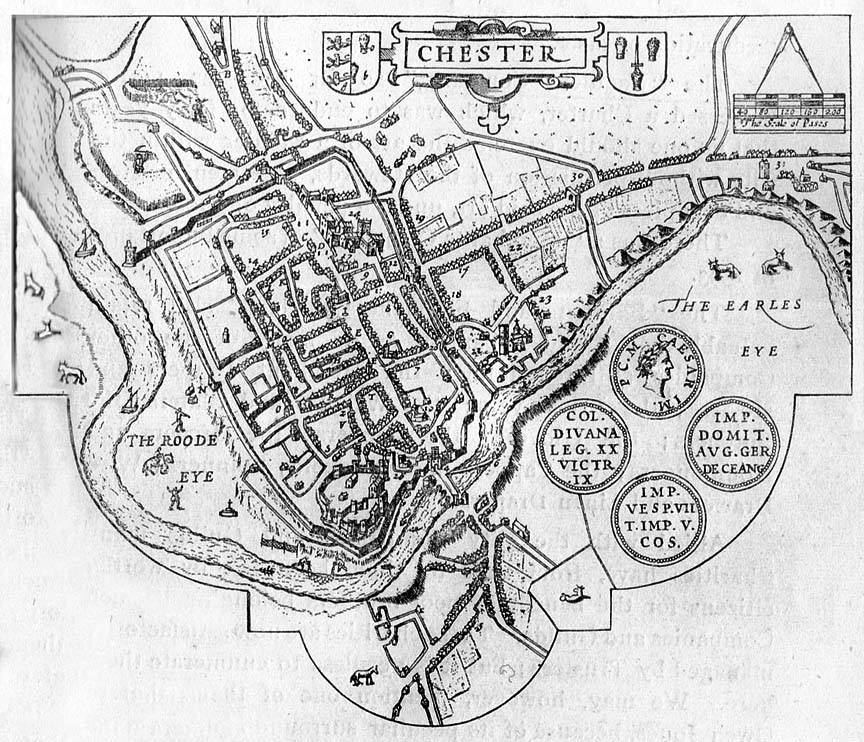

John Speed's Map of Chester 1610

This map was drawn a mere forty years after that of Braun, and is a much less elaborate affair. It is nevertheless probably the best known of the early maps of Chester. It was originally a vignette in Speed's Maps of Cheshire, but was reprinted in its own right at least fourteen times between 1616 and 1770.

The most interesting difference between the two is that in these few decades, the River Dee in the later map has retreated considerably and has moved away from the Watergate and City Wall, and the Watertower is shown standing clear of the river Dee. Smith's map, made just twenty five years earlier, also shows the river flowing against the City Walls. Just above the Watertower you may see a man with a scythe standing in a field of corn- where later would be Tower Wharf- and all around the cows continue to graze...

As in the Braun map, the gallows continue to stand above the Earl's Eye (The Meadows) in Boughton (on the right hand side).

Speed wrote of the origins of the city, "that it was raised from the fort of Ostorios, Lieutenant of Britain for Claudius the Emperor, wither the 20th Legion (named Victrix) were sent by Galba to restrain the Britons, but grown themselves out order Julius Agricola was appointed their General by Vespasian, as appeareth by monies then minted, and there found; and from them (no doubt) by the Britons the place was called Caer Legion; by Ptolemy Deunana, by Antoine Deva, by the Saxons West-Chester, but Henry Bradshaw will have it built before Brute, by the giant Leon Gawr, a man beyond the moon and called by Marius the vanquisher of the Picts... King Leir (Shakespeare's King Lear) - a Briton fine and valiant, was founder of Chester by pleasant building, which was named Guer Leir by the King".

In explanation, it is conjectured that, after the withdrawal of the Legions, the Britons (Welsh) long referred to the abandoned fortress as Caer Leon Vawr (Camp of the Legions) which was misinterpreted by some as referring to the mythical giant Leon Gawr.

John Speed was born at Farndon near Chester, but spent most of his life in London working as a tailor. His extraordinary historical learning eventually brought him to the attention of Sir Fulke Grenville and Sir Henry Spellman and enable him to publish his series of maps of England and Wales under the title of the Theatre of the Empire of Great Britain. He died at the age of 87 in 1629.

Go here to read more of John Speed's impressions of Chester and here to learn about his life and times.

On to Daniel Meisner's View of Chester 1620

Site Front Door | Chester Walls Stroll Introduction | Old Maps & Aerial Photographs | Site Index