  ooking further up the canal in the old photograph on the previous page, the church whose steeple may just be seen through the murk on the right hand side of the canal- the Methodist Central Hall- was demolished in the 1970s and the site is now occupied by a car park next to two modern blocks of flats. These may be seen in the modern photograph together with the tower blocks which sprang up next to the Inner Ring Road at the end of the 1960s. Parts of the old church may still be seen adhering to the side of the road. ooking further up the canal in the old photograph on the previous page, the church whose steeple may just be seen through the murk on the right hand side of the canal- the Methodist Central Hall- was demolished in the 1970s and the site is now occupied by a car park next to two modern blocks of flats. These may be seen in the modern photograph together with the tower blocks which sprang up next to the Inner Ring Road at the end of the 1960s. Parts of the old church may still be seen adhering to the side of the road.
(Also visible in the distance on the left of the newer picture are Chester Cathedral and, beyond it, the tower of the Victorian Gothic Town Hall)
The tall square tower on the left of the canal, however, is very much still with us, belonging as it does to the Steam Mill, of which more below.
 The canal towpath in the old picture appears to be in a poor condition and full of potholes- a situation which continued until just a few years ago when a new cycletrack and footpath were laid, which today provides Chester's citizens with a superb car-free route into the city centre and beyond. The canal towpath in the old picture appears to be in a poor condition and full of potholes- a situation which continued until just a few years ago when a new cycletrack and footpath were laid, which today provides Chester's citizens with a superb car-free route into the city centre and beyond.
You can see some dramatic 'before and after' pictures of the towpath here... and modern view of the canal and the tower from where this photograph was taken may be seen here. In addition, a dramatic view from the very top of the Leadworks Shot Tower is here...
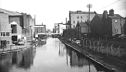
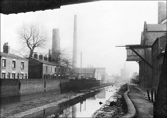
Above is part of the Chester stretch of the Shropshire Union Canal as it appeared around 1970. It all looks rather scruffy and neglected but signs of the great changes to which this area was soon to be subject are also in evidence in the shape of the white strip crossing the canal in the distance- the newly constructed St. Oswald's Way section of the Inner Ring Road, which was completed in January 1971.
The photograph was taken from Cow Lane Bridge, which was totally rebuilt when the ring road was constructed. This stretch of the canal is still known to more senior Cestrians by the mysterious name of 'Botany Bay'.
In the distance, just beyond the new bridge on the left is the Griffiths Brother's mill which was later restored and converted into what is now the Mill Hotel (see below). To its right, across the canal, the tall building is the Steam Mill, at this time the home of Miln's Seeds, which was also later superbly restored and today serves as a business centre, housing offices, studios and a bar / restaurant.
 In the far distance may just be glimpsed the tall Water Tower belonging to the Chester Water Company in Boughton, situated close to the springs that served both the Roman fortress and medieval Abbey and town. A section of lead pipe that once formed part of this advanced system was found in Foregate Street and is inscribed, "'This lead pipe was made when Vespasian and Titus were Consuls for the ninth and seventh times respectively and when Cnaeus Julius Agricola was Governor of Britain". In the far distance may just be glimpsed the tall Water Tower belonging to the Chester Water Company in Boughton, situated close to the springs that served both the Roman fortress and medieval Abbey and town. A section of lead pipe that once formed part of this advanced system was found in Foregate Street and is inscribed, "'This lead pipe was made when Vespasian and Titus were Consuls for the ninth and seventh times respectively and when Cnaeus Julius Agricola was Governor of Britain".
Julius Agricola was Governor of Britain from AD 78-86. A Roman altar, "dedicated to the Nymphs and Fountains" was found close to the site of the waterworks and is now in the gardens at Eaton Hall, home of the Duke of Westminster.
In 1537 a Doctor Wall built new conduits from Boughton for conveying water to the Bridge Gate, and in 1582 the conduit began to bring the water to the High Cross in the centre of the City. In 1622, by grant from the Mayor and Citizens of the City, John Tyrer undertook to build waterworks at Boughton. The undertaking was carried on until the first water company with statutory powers was formed in 1826.
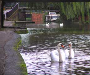
The same source continues to supply Chester with good water to this day. Go here to see a closer, contemporary photograph of the Water Tower.
 Nearer to us, the large building on the left was built in 1931 as a cinema- the Gaumont Palace- but today serves as a popular bingo club. The road along the left-hand side of the canal is Union Terrace, which led to the businesslike-sounding Cement Place and Leadworks Lane. Nearer to us, the large building on the left was built in 1931 as a cinema- the Gaumont Palace- but today serves as a popular bingo club. The road along the left-hand side of the canal is Union Terrace, which led to the businesslike-sounding Cement Place and Leadworks Lane.
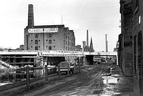
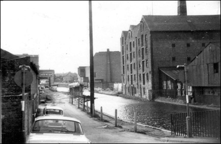
This photograph of Canalside- the road along the right-hand side of the canal as we view it- was taken around the same time as the one above, showing the Ring Road bridge during the course of construction.
The industrial buildings around Queen Street on the right have since been replaced with new houses. The bulk of the Griffiths Brothers Mill, "Provender Millers and Merchants", later the Mill Hotel, dominates the background.
Beyond that, the chapel on Queen's Avenue- the Methodist Central Hall- was demolished in the 1970s and the site is now occupied by a car park next to two modern blocks of flats, and behind that again may be seen the tall chimneys of the Chester Leadworks. Of these, only the listed Shot Tower of 1799 survives today. This was one of only three such towers built to manufacture musket shot for the Napoleonic Wars and might, therefore, have been instrumental in the deaths of many French soldiers.
 The old buildings around it are due to disappear in the near future to make way for a large housing development. Here is the same location as viewed from the other direction, and also a photograph from a decade or so earlier, showing how the canal appeared from the top of the Water Tower... The old buildings around it are due to disappear in the near future to make way for a large housing development. Here is the same location as viewed from the other direction, and also a photograph from a decade or so earlier, showing how the canal appeared from the top of the Water Tower...
Here is a view taken from the St. Oswald's Way bridge on the Inner Ring Road in July 1999, showing how very much things have changed in the environment of Chester's canal over the last few decades...
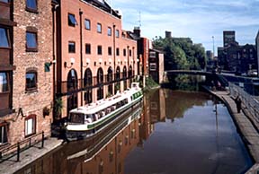
The Mill Hotel and its 'floating restaurant' may be seen on the left, together with its first modern extension- a further extension has recently been completed on the other side of the canal, connected to the old building by a footbridge.
 Beyond the hotel is the bridge connecting Seller Street with Egerton Street. Passing beneath it, you will notice that the ironwork of this bridge is deeply worn by the tow ropes of the great horses that pulled barges along the canal in former days. Beyond the hotel is the bridge connecting Seller Street with Egerton Street. Passing beneath it, you will notice that the ironwork of this bridge is deeply worn by the tow ropes of the great horses that pulled barges along the canal in former days.
The towpath stayed in much the same appalling condition as it was in the top photograph until just a few years ago, when- after many complaints and a lengthy campaign- it was finally restored with the aid of 'Landfill Tax' money and now provides Chester's citizens with an excellent, car-free cycle / footpath into the city centre and beyond. You can see a couple of 'before and after' pictures of it here...
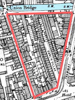
A large area of long-derelict land facing Seller Street- just out of shot on the right- has recently become another new housing development. All the buildings on the left of this photograph- the former premises of Witter's Towbars and, beyond them, Earl's Villas- vanished at this time.
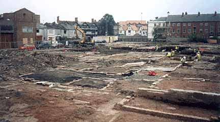
It is difficult to believe, looking at the photograph above that this area was formerly densely covered by houses and industrial premises, as may be seen in this detail from the 1898 Chester Ordnance Survey map.
 It was not until the 18th century that these backlands began to be built upon. The opening of the canal in 1779 accelerated the process and Seller Street (the left-hand border) was lined with buildings by 1833. In the sixty years between then and the publishing of this map, the entire area had been rapidly acquired by speculative builders and filled with houses. It was not until the 18th century that these backlands began to be built upon. The opening of the canal in 1779 accelerated the process and Seller Street (the left-hand border) was lined with buildings by 1833. In the sixty years between then and the publishing of this map, the entire area had been rapidly acquired by speculative builders and filled with houses.
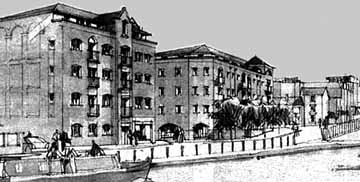
Here we see an artist's impression of the enormous new £11.5 million development of apartments which were recently constructed, consisting of six, three- and four-storey blocks in addition to a number of commercial units for restaurant and retail use, totalling around 100,000 sq feet.
Built in the style of the industrial warehouses of the past, they have become rather a handsome addition to the canalside scene. An interesting sculpture was recently added to their gardens facing upon the canal that resembles a series of outsized tillers in memory of the working barges that long passed this way- and the pleasure craft that continue to do so today. A photograph of them may be seen on our next page...
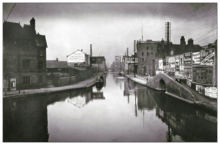
| For those familiar with the view of Chester's canal from Cow Lane Bridge, this dramatic old photograph will prove interesting. The massive Gaumont Palace Cinema has yet to replace the buildings on the left-hand side. It opened in1931. You can see it in the top photograph. The arched bridge giving access to a branch of the canal and its advertising hoarding has long gone and the area was developed for a Tesco store and car park. Nothing seems familiar until we see the Steam Mill and what is now the Mill Hotel in the distance.. |
A view of a very dilapidated canal sometime in the 1920s. The Steam Mill is on the right.
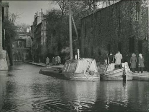
The Chester Canal near the Bridge of Sighs by Edward Chambré Hardman
Go on to part III of our exploration of the Chester Canal
|
