Chester: a Virtual Stroll Around the Walls
Details
from
John
McGahey's
View
of
Chester
from
a
Balloon
1855:
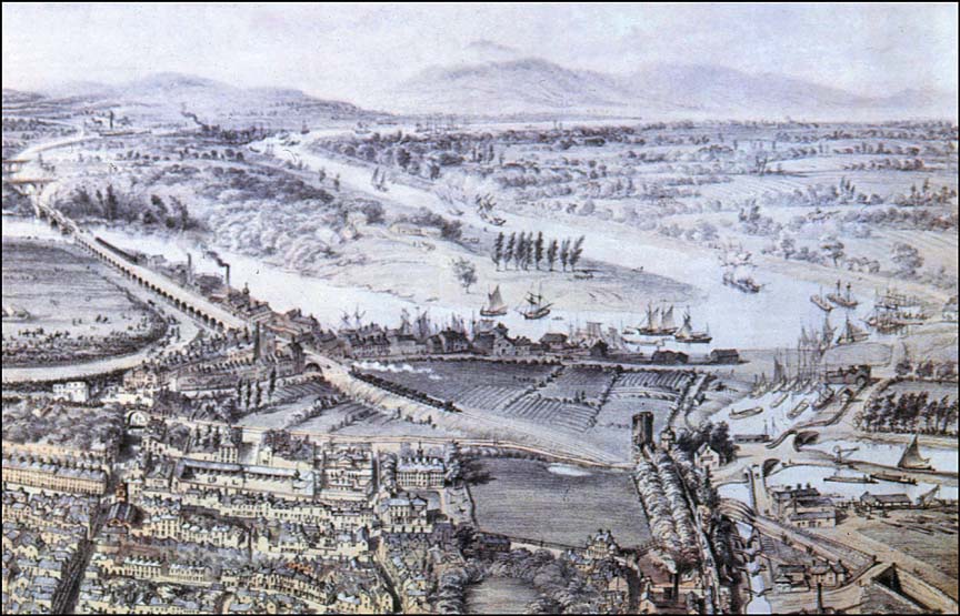
1.
The
Old
Port
Area
|
This
detail
from
John
McGahey's
highly
detailed
chromolithographic
print
of
Chester
as
she
appeared
in
the
year
1855
shows
numerous
sailing
ships
negotiating
the
River
Dee.
Due
to
centuries
of
silting,
the
formerly-considerable
river
trade
had
been
largely
destroyed
until
this
section
was
canalised
over a century earlier, in 1730.
New
wharves
and
warehouses
were
constructed on what was once the old river bed
and
these
may
be
seen
in
the
centre
of
the
picture. The area is known today as The Old Port. Below the bridge, the large circular open area is The Roodee, the oldest racecourse in Britain (and therefore, probably, in the world). Race meetings have been regularly held here on the "soup-plate racecourse" since 1540. You can actually see a race in progress, the horses rounding the bend next to the railway viaduct, watched by a large crowd. To
its
left,
the
large
piece
of
open
land
was
anciently
known
as Lady
Barrow's
Hey,
'hey'
being
a
Saxon
name
for
a
field
enclosed
with
hedges.
Earlier
still,
this
area
had
been
used
by
the
Romans
as
a
cemetery
and
many
graves
were
uncovered
when
the
Chester
Royal
Infirmary-
seen
to
the
left
of
the
field-
was
being
built
in
1761.
All
traces
of
the
open
land
disappeared
as
the
hospital
expanded
over
the
next
200
years.
It
finally
closed
in
1993
after
230
years
of
medical
care
on
the
site,
all
services
were
transferred
to
the
Countess
of
Chester
Hospital
on
Liverpool
Road
and
the
site
was
sold
for
new
housing.
Other enlarged sections from John McGahey's wonderful illustration:
|
 With
the
continuing
silting
of
the
Dee
and
the
meteoric
rise
of
the
With
the
continuing
silting
of
the
Dee
and
the
meteoric
rise
of
the
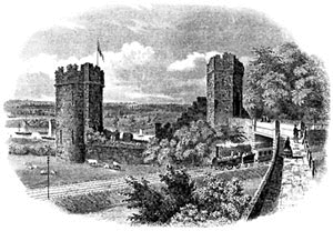
 The
ancient
line
of
the
city
wall
cuts
up
the
centre
of
the
picture,
at
the
corner
of
which
you
can
see the wonderfully-named Bonewaldesthorne's Tower and, below it, the the
The
ancient
line
of
the
city
wall
cuts
up
the
centre
of
the
picture,
at
the
corner
of
which
you
can
see the wonderfully-named Bonewaldesthorne's Tower and, below it, the the  Above this, the peninsula of rural land across the River Dee is today occupied by
 Site
Front
Door
|
Chester
Stroll
Introduction
|
Old
Maps
index
|
View
from
a
Balloon
|
Site
Index