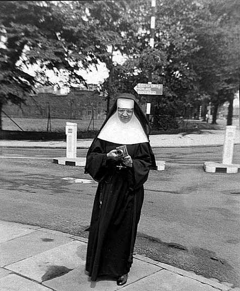
Chris's Aunt, Sister Mary Vincent CCVI. ("Somewhere I think I have rolls of 16mm film taken by the camera she is holding").
Most aptly, she is standing on the corner of Grosvenor Road and... Nun's Road! So called because it occupies part of the site of the Benedictine Nunnery of St. Mary's which stood here from Saxon times until the reign of Henry VIII. In 1537, along with the neighbouring houses of the Black, White and Greyfriars, it was dissolved and the nuns cast out to fend for themselves.
It is, however, recorded that the prioress and eleven other nuns were given pensions which they were still receiving 21 years later, in 1556.
The actual priory buildings survived for another 100 or so years, part of them becoming the home of Sir William Brereton- at least until he became leader of local Parliamentary forces during the English Civil War, when the buildings were attacked by an angry mob of citizens loyal to the King. At around the same time, the open land around them became known as The Nun's Field.
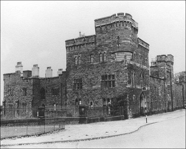
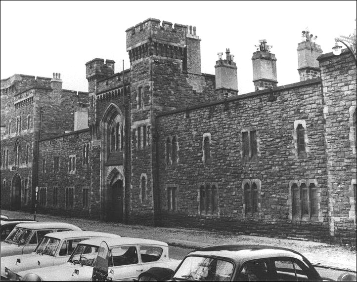
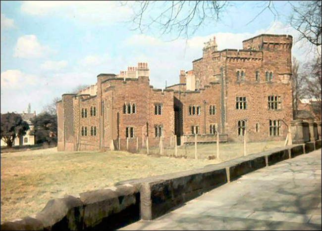
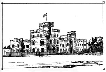
 Behind Sister Mary may be seen the castle-like Militia Buildings which were built just after the Crimea War in 1854-6 and were used as married quarters for the families of troops serving at Chester Castle. Behind Sister Mary may be seen the castle-like Militia Buildings which were built just after the Crimea War in 1854-6 and were used as married quarters for the families of troops serving at Chester Castle.
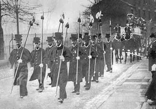
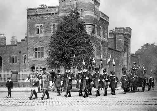
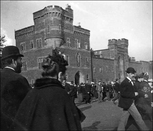
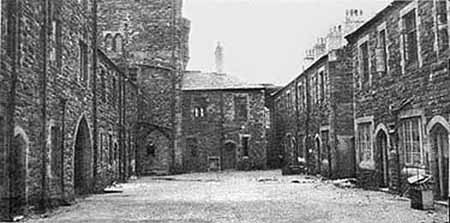
On the right is a rare closeup view of the Militia Buildings and you can see a couple more old photographs of it below, which also show Chester's forgotten 'Beefeaters'- dressed similarly to their surviving brethren at the Tower of London- the Javelin Men who once escorted the Judge's coach to the assizes at the Castle.
Today, the old Militia Buildings would doubtless be listed as architectually important and in demand for conversion into 'luxury' apartments but they were sadly demolished to make way for the exceedingly ugly and inappropriately-sited County Police Headquarters, which was built between 1964 and 1967. This in turn was demolished in October 2006 and is now being replaced by HQ, an enormous hotel and apartment complex. You can learn more and see both buildings here.
In February 2008, Ian Thirlwell of Hampshire wrote to us, "I've just found your web site and browsing around was delighted to find a photograph of the inside yard of the Militia Buildings. My father was in the army, and in 1951 we moved to Chester where our first married quarters was in the Militia Buildings. The conditions of the quarters were not good though, and my mother lobbied to get us moved quickly. We went to The Dale (aka Percy Road now Percival Road) which was also not up to standard and soon moved round the corner to Simpson Road.
While in the Militia Buildings, I remember waking to the cathedral bells pealing, and walking to primary school at St Mary's Hill. My first view of television was in the barracks across the main road from the Militia Buildings, where a small group of us children would go to watch a children's program.
In the 1970s, when British Railways still ran the trains, I revisited Chester on a rail excursion and went to see the Militia Buildings. Of course they were no longer there, and an enquiry at the Police HQ didn't produce any answer as to the fate of the buildings.
I don't remember much about the Militia Buildings themselves except where they were, and the dwellings were around a courtyard. I think there was still a bit of field on the Grosvenor Bridge side. Somewhere there I remember my Dad & I flying a box kite that had the misfortune to dive into a fence or something & broke up. Thinking about the bells that I mentioned, it may not have been from the cathedral, but the chimes from a clock somewhere near. According to the National Registration ID cards we still have, we were in no. 17 Militia Buildings. I don't remember horse races on the Roodee, but it was a place we went for walks I think. It may also have been the place where there was some kind of event including medieval jousting, and men flying model planes on control wires- they flew round and round in circles). This would probably have been between March and July 1951 if it was during our time in the Militia Buildings. I'd be interested if you have any information that would confirm such an event.
The Dale (Percy Road/Percival Road) is just a dim memory & we seem to have no photos to help. Looking at maps on Google this road seems not to have changed a lot. I think I can even identify which house we lived in, no. 15, the last one on the south side. Simpson Road is clearer, though modern maps show a larger housing estate beyond where we lived, the last but one semi, no. 11, on our side of the road in 1951/52. In 1952 we moved out to Saighton Camp, to Wavells Way. This road seems not to have changed, though the camp itself has. Nowadays, of course, there is the A55 dual carriageway nearby.
As far as schools go, after St. Mary's Hill (I've always known it as St Mary's on the Hill, and still have an image of it in my mind), I went to Backford, then St Mary's, Upton, both scarcely remembered and lastly Alford when we moved to Saighton. I have several memories of Alford, spending a couple of years there. We used to catch a bus from outside the camp gates, where the road from Chester divided. One winter, when there was quite a lot of snow, the bus was late so I started walking until it caught up with me. I can't imagine a young child (under 10 years old) doing that these days!"
Some more pictures of the Militia Buildings by other photographers... |