Chester: a Virtual Stroll Around the Walls

Old Maps and Aerial Photographs of Chester
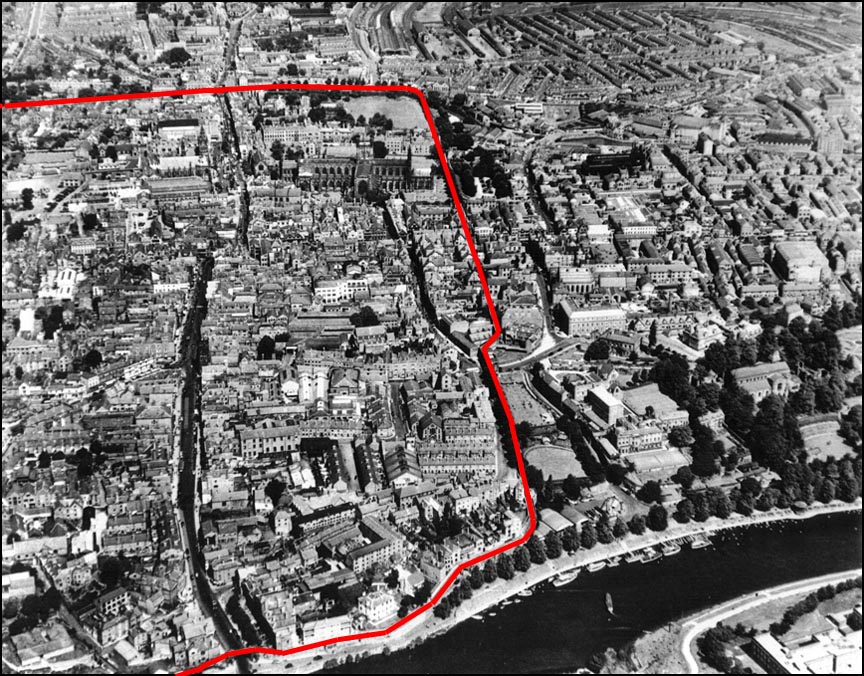

Chester from the Air: River Dee and City, looking north-east: 1950s

Our picture shows the River Dee and southern aspect of the city of Chester. Bridge Street runs up the left-hand side of the photograph towards the Cross, beyond which runs Northgate Street.

The red line indicates the course of the City Walls, within the north east corner of which stands the Cathedral. Just past the wall's 'dog-leg' on the right-hand side, the dense collection of buildings bordering Newgate Street have yet to be cleared to make way for the Grosvenor Shopping Precinct. The well-preserved remains of an enormous Roman bath house were discoved here, but were entirely destroyed by the developers.

South of the River Dee- in the bottom right-hand corner- the large buildings at this time belonging to the Ministry of Defence have recently given way to the headquarters building of Capital Bank- now the Halifax Bank of Scotland.

The Cattle Market- seen in the top right-hand corner- at Gorse Stacks was still standing at this time and the circular area next to the City Wall and below the 'Roman Garden', once the site of a cock-pit, was still a well-maintained bowling green. A pub was later built on the Groves here (now known as The Groves Bar & Bistro) and the bowling green allowed to become neglected and overgrown. After remaining derelict for many years, it has recently been beautifully landscaped to allow the Roman Garden to continue down the the river.

To the right of this garden, St. John's House still stands on the as-yet unexcavated Roman amphitheatre. It was demolished in June 1958 to allow the northern half to be uncovered. In February 2000, despite huge public objection, the still-buried southern half had an office block and car park built on top of it...

On to another aerial photograph of Chester...


Site Front Door | Chester Walls Stroll Introduction | Old Maps & Aerial Photographs