The
Black & White
Picture
Place
Old Maps and Aerial Photographs of Chester

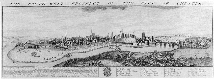
The South West Prospect of the City of Chester 1728
This engraving by Nathaniel Buck is particularly interesting in that it is possibly the last such illustration to show the River Dee following its original- and, by this time, terminally silted- course before it was radically altered and turned into a new, man-made channel just four years later, in 1732. Actually, it seems likely that, as this engraving drew heavily upon the work of earlier artists, its view of the wide river and the docks under the Watertower on the far left were probably hopelessly out-of-date by this time. After the canalisation of the Dee, efforts were made to re-establish Chester's former thriving sea trade and a whole new system of docks were established, standing far out from the City Walls, in what was the old riverbed- the middle of the channel shown on the illustration- still known today as The Old Port. This had only limited success as the river continued to silt and nowhere near enough time and money was spent to maintain the new cut. Inevitably, the Port of Chester- for centuries the most important seaport in Northern England- died and a small fishing and trading community on the neighbouring River Mersey, once referred to as a mere "creek of the Port of Chester" took up the reins and grew meteorically into a great international seaport- Liverpool. Also of interest is the Castle, standing in the middle of the picture on its high motte- the great man-made mound of earth contructed here by the Norman conquerors around the year 1080. By the middle of the 18th century, this medieval castle was ruinous and, by 1788, much of it had been demolished to allow for Thomas Harrison's radical rebuilding in the Greek Revival style. Much remains familiar to the modern resident, however; the City Wall winds around the city, horse racing can be seen taking place on the Roodee, the Cathedral and many of the city's churches can be identified and the Old Dee Bridge crosses the Dee just as it does today... Here are some detailed englargements of the above view: (Notes for these are in preparation...) |
On to Lavaux's map of Chester 1745
Site
Front
Door
|
Chester
Walls
Stroll
Introduction
|
Old
Maps & Aerial
Photographs
|
Site
Index