The Black & White Picture Place
Old Maps and Aerial Photographs of Chester
Lavaux's Map of Chester 1745: the Northgate area
The
Black & White
Picture
Place
Old Maps and Aerial Photographs of Chester
Lavaux's Map of Chester 1745: the Northgate area
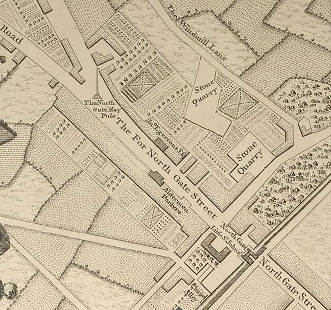
| In this, an enlargement from Lavaux's map of Chester, we see the Northgate area as it appeared in the middle of the 18th century. Northgate Street, the Via Decumana of Roman times, is as we know it today but, beyond the City Walls, what we now refer to as 'Upper Northgate Street' is curiously named 'The For North Gate Street'. Just before it splits into the Parkgate and Liverpool roads, we see 'the Northgate May Pole' - something not shown on any other Chester map that we know of. Another, better known maypole also stood at this time across the River Dee in Handbridge and can be seen on this detail from Lavaux's fine map. 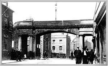 The original Roman gateway here was called the Porta Decumana. Soon after the Normans came to Chester- the last city in Britain to the conquerors- the Northgate shown on the map was erected, standing upon the foundations of its Roman predecessor. It was a heavily fortified structure that housed a dreadful prison that stayed in use for over seven centuries. It was eventually demolished in the early years of the nineteenth century- the last of Chester's gates to be replaced- and in its place rose the Thomas Harrison's elegant classical arch that remains with us today. The original Roman gateway here was called the Porta Decumana. Soon after the Normans came to Chester- the last city in Britain to the conquerors- the Northgate shown on the map was erected, standing upon the foundations of its Roman predecessor. It was a heavily fortified structure that housed a dreadful prison that stayed in use for over seven centuries. It was eventually demolished in the early years of the nineteenth century- the last of Chester's gates to be replaced- and in its place rose the Thomas Harrison's elegant classical arch that remains with us today.Curious to modern eyes is the absence of the Shropshire Union Canal which was constructed running alongside the city wall thirty years after this map was made. The stone quarry on George Street, in use since Roman times (supplying sandstone for the construction of the nearby City Wall), was eventually filled up in the nineteenth century and the land covered in housing and industrial premises. In the 1960s, a bus station was situated here which was removed in 2007. A new complex of shops and apartments is currently being built on the site and, in preparation for the construction of an undergound car park, the ancient quarry was re-excavated. 'The Windmill Lane' at the top of the map later became Victoria Road- and later still became separated into two unconnected parts when the St. Oswald's Way stretch of the Inner Ring Road was built in the 1960s. |
|
|
|
|
|
|
|
|
Back to Lavaux's map of Chester
Site
Front
Door
|
Chester
Walls
Stroll
Introduction
|
Old
Maps
&
Aerial
Photographs
|
Site
Index