Chester: a Virtual Stroll Around the Walls
Old Maps and Aerial Photographs of Chester
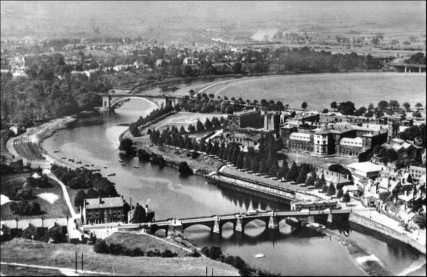
Chester from the Air: River Dee looking north-west
|
This lovely aerial photograph of the River Dee was taken sometime early in the 20th century, before the demolition of Thomas Harrison's prison (seen on the right) which had opened in 1792. The site is now occupied by County Hall. Next to the gaol, the 13th century Agricola Tower rises above Harrison's rebuilt Castle and behind this is the approach road to his final work, which he did not live to see completed- the beautiful Grosvenor Bridge of 1832. Behind all lies the great open area of the Roodee, the home of Chester Racecourse. Closer to us, on the other side of the great embankment thrown up to carry Grosvenor Road to the bridge, the Little Roodee is seen to be open ground, apparently criss-crossed by paths. Today, it lies beneath a layer of tarmac and is a utilitarian space, used as a car park- except for a week in the springtime when Pat Collins' funfair sets up there. In the foreground, the Norman weir leads to the Old Dee Bridge, which crossed the river just as it does today- and has continued to do for over 600 years. The building standing at its southern end is the Ship Inn and beyond is an open area anciently known as Edgar's Field. Moored in the river here can be seen the boats of the Dee salmon fishermen- of whom you can see a photograph, approximately contemporary with the one above, here. Compare this view with the watercolour by Louise Rayner and also that recorded by John McGahey as he hung beneath his balloon in 1855 ... |
On to another aerial photograph of Chester...
Site Front Door | Chester
Walls Stroll Introduction | Old Maps & Aerial Photographs