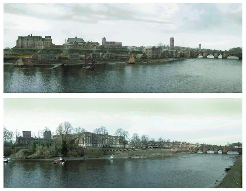
We commence with this wonderfully evocative view of Chester as seen from across the River Dee as it would have appeared in the middle of the 18th century, contrasted with the same view today.
It is the work of the artist Martin Moss.
The medieval Chester Castle is seen on the far left. To its right is the Shire Hall, the 'parliament' of the powerful Earls of Chester. The picture shows it in its final days as both of these were almost completely swept away around 1780 and the 'castle' we know today was built on the same site by the prolific Chester architect Thomas Harrison between the years 1785 and 1822. The so-called 'Agricola Tower'- the second high building from the left in the modern view- was, however, retained and remains standing today. Martin has also created this remarkable aerial view of the old and new castles.
On the high ground in the centre of the old image may be seen the ancient church of St. Mary-Within-the-Walls, of which more below.
The squalid houses, workshops and warehouses lining the riverbank in front of the City Wall lay along a long-vanished thoroughfare called Skinner's Lane, where all mannner of trades that were either water-dependent or deemed too unsavory or polluting to be tolerated within the town were practiced- tanning, rendering, chemical works and the like. All of this vanished when the line of the City Walls and river defences were altered when Harrison's prison (see below) was erected here in 1807.
The tall water storage tower we see in the distance was built onto the Bridgegate in 1692 by John Hadley and John Hopkins to replace an earlier one, known as Tyrer's Tower, which was destroyed during the Civil War Siege of Chester. It stood until the old Bridgegate was demolished in 1782.
In the far distance we can just see the tall Gothic West Tower of the venerable Church of St. John the Baptist, for a while Chester's first cathedral, a landmark for centuries until it fell down in 1881.
Unchanged in the two views is the venerable Old
Dee Bridge, comprising seven unequal arches and built, much as we see it
today, about the year 1387 on the site of a succession of earlier wooden bridges
and a pre-Roman fording place. For hundreds of years, until the coming of Harrison's beautiful Grosvenor Bridge in 1832, it provided the only passage across the River Dee. The side furthest from our viewpoint was widened to allow a walkway to be added in the 1820s but the seaward side we see here has remained substantially the same throughout the long centuries.
Compare these images with this watercolour of the area by the prolific artist Louise Rayner...
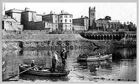 Here
is
an
interesting
photograph
of
fishermen
on
the
Dee sometime
during
the
late
19th
century,
before
Thomas
Harrison's
County
Gaol,
in
the
background,
was
demolished.
(Those
cells
which
faced
towards
the
river
must
have
had
spectacular
views!)
This
had
been
built
in
1807
to
replace
the
squalid
prison
in
the Northgate-
you
will
see
another
picture
of
it
when
we
come
to
the Infirmary section
of
our
walk.
The
site
has since 1957 been
occupied
by County
Hall,
which
today
unfortunately
obstructs
the
view
from
the
river
of
the
fine
medieval
church
of St. Mary-on-the-Hill. Our
photograph
shows
it
entirely
unhemmed
in
by
buildings. Built as the headquarters of the now-disbanded Cheshire County Council, the building now forms part of Chester University.
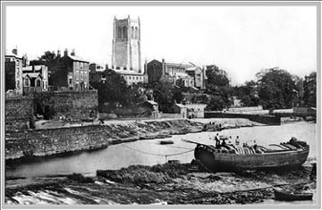
Here
is
an
interesting
photograph
of
fishermen
on
the
Dee sometime
during
the
late
19th
century,
before
Thomas
Harrison's
County
Gaol,
in
the
background,
was
demolished.
(Those
cells
which
faced
towards
the
river
must
have
had
spectacular
views!)
This
had
been
built
in
1807
to
replace
the
squalid
prison
in
the Northgate-
you
will
see
another
picture
of
it
when
we
come
to
the Infirmary section
of
our
walk.
The
site
has since 1957 been
occupied
by County
Hall,
which
today
unfortunately
obstructs
the
view
from
the
river
of
the
fine
medieval
church
of St. Mary-on-the-Hill. Our
photograph
shows
it
entirely
unhemmed
in
by
buildings. Built as the headquarters of the now-disbanded Cheshire County Council, the building now forms part of Chester University.
The church is also known as St. Mary-Within-the-Walls to distinguish it from
the first church to be built on the other side of the river, St. Mary-Without-the-Walls in Handbridge, whose fine tall spire is clearly visible from all around. Built in 1887, occupying a site of a Roman cemetery, it was a gift to the city from the Duke of Westminster.
St. Mary-Within-the-Walls, however, has a far more reaching history. The original church on the spot, dating from around 1350, was known as St. Mary de Castro ('of the Castle'). and erected partly to serve the needs of the garrison and staff of the neighbouring Chester Castle. Some of the present church dates from a rebuilding in the 16th century and the porch contains stones brought from the nunnery of St. Mary's, which once stood overlooking the Roodee where the new HQ building now stands. The tower was once much lower than it is today- as a precaution against attack it was forbidden for any neighbouring building to overlook the walls of the castle. The ornately-carved upper 30 ft of the tower we see today were added by the castle's re-builder, Thomas Harrison in
1861-2. He also renewed much of the external sandstone masonry. Further restoration work, including the rebuilding of the north porch, was carried out in 1861-2 by John Pollard Seddon, at the expense of the Chester Freemasons.
The interior of the church is very fine and boasts a splendid English oak inner roof, brought from Basingwerk Abbey (whose picturesque ruins still survive near Holywell in North Wales) when that establishment was dissolved by the agents of King Henry VIII. Many of Chester's greatest citizens were buried here and some of their monuments are likely to surprise the visitor, being as they are painted in bright colours. One such notable 17th century tomb bears effigies of Thomas Gamul, attended by his wife and children and another commemorates the Randle Holmes family of heraldic painters.
The church became redundant in 1972, but was never deconsecrated, and today hosts an education centre operated by the local authority.
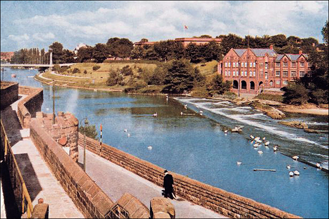
You
can
just
glimpse
the Agricola
Tower of
the Castle on
the
far
left- one of the few medieval sections to survive Harrison's radical rebuilding in the 18th and 19th centuries.
The River Dee has for long been one of the most important salmon rivers in the country. The important reaches for salmon angling are the Dee and its tributaries upstream of Bangor on Dee; angling downstream of this point is important for trout and coarse fish, but in virtually the whole of the river system trout can be found.
There are two hatcheries on the river system, a trout hatchery operated commercially and a salmon and trout hatchery operated by the Water Authority. The latter is used to improve the salmon and trout stocks of the river, and the Authority uses a number of moorland streams cleared of trout and other predators, as "nurseries" for the small salmon bred at the hatchery.
In the estuary and the canalised reach of the river, a limited number of salmon netmen operate, and the estuary is also the source of flounder and shrimp. Small flounder may be observed to be a favourite of the growing number of cormorants that inhabit the river, especially in the vicinity of the Old Dee Bridge and weir.
 The
salmon
fishing
community
lived
in
Greenaway Street and the courts surrounding it in Handbridge,
across
the
Dee
from
Chester.
They
all
had
their
own
jealously-guarded
named
spots
to
fish from,
such
as Marshead, Lane
End, Under
the
Hills, Crane and Littlewood.
Once
there
were
fourteen
such
places
within
two
miles
of
the Old
Dee
Bridge,
today
there
are
six
remaining.
The
salmon
fishing
community
lived
in
Greenaway Street and the courts surrounding it in Handbridge,
across
the
Dee
from
Chester.
They
all
had
their
own
jealously-guarded
named
spots
to
fish from,
such
as Marshead, Lane
End, Under
the
Hills, Crane and Littlewood.
Once
there
were
fourteen
such
places
within
two
miles
of
the Old
Dee
Bridge,
today
there
are
six
remaining.
Joseph
Hemingway,
writing
in
1835,
said,
"In
that
useful
article,
salmon,
no
market
in
the
kingdom
did,
some
few
years
ago,
excel
it;
indeed,
such
was
the
profusion
of
that
valuable
fish,
that
masters
were
often
restricted,
by
a
clause
in
the
indentiture,
from
giving
it
more
than
twice
a
week
to
their
apprentices.
Though
the
bounty
of
providence,
in
this
particular,
is
yet
unabated,
such
restriction
is
no
longer
necessary-
some
artificial
cause,
or
other
very
kindly,
rendering
this
fish,
at
the
present
day,
a
delicacy
even
to
the
masters
themselves...
The
supply
was
so
great,
that
after
furnishing
our
own
market
for
the
city
and
neighbourhood,
five
or
six
carts
were
employed
in
conveying
it
for
sale
to
distant
places".
Right: A
view
of
the
area
today
known
as The Groves,
taken
sometime
prior
to
1881, when
the
great
medieval
tower
of St.
John's
Church,
which
you
can
see
in
the
background,
collapsed.
In the foreground is the weir constructed in the 11th century to direct the flow of the river toward the last two arches of the Old Dee Bridge where waterwheels powered a series of mills.
In the 18th and 19th centuries, if a barge on the Shropshire Union Canal needed to unload at the mills, the lock gate into the Dee could only be opened on a flood tide. Navigating a craft designed for canal use was risky work; extra hands were needed with long poles to help keep the barge straight. The picture shows the result of getting it wrong. Having failed to tie up at the mill, the barge has been carried on under the bridge and stranded in top of the causeway as the tide recedes. It was recorded that "It took nearly all the carthorses in Chester" to pull her off.
When this photograph was taken, the river bank has not yet been formerly 'laid out', planted with trees and provided with the seating and bandstand we know and enjoy today.
 Go here to see a beautiful etching of the area by A.Godwin from around the same time.
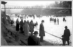
Left: We
move
forward
in
time
fifty
years
or
so,
to
February
1929,
and
this
view
of
The Groves and
the
frozen
River
Dee
by
photographer
Mark
Cook,
whose
studio
was
on
the
City
Walls
nearby.
It
shows
the
same
part
of
the
riverbank
we
can
see
in
the
photograph
above.
Many
people
have
turned
out
to
enjoy
the
novel
new
playground,
a
lot
of
whom
have
braved
the
ice,
though
the
spectators
in
the
foreground
seem
happy
to
remain
safely
on
the
bank!
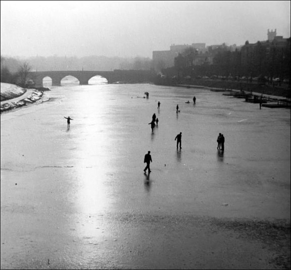
This novelty of strolling where water usually flows was by no means a new one; in 1739, for example, "This year commenced the great frost which continued thirteen weeks. The ice on St. John's Dee was above three feet thick; and a large sheep was roasted whole upon it, opposite the Bowling-green. Carts and horses laden went frequently over the river."
In 1564 it was recorded that "this year there was a great frost, and the Dee was frozen over, so that people played at football thereon". This, as far as we can tell, is the earliest know reference to the 'beautiful game' in Cheshire.
Tragedies could occur however, as in 1599; "The 27th of January the River Dee was frozen over, and certain of the Citizens went to walk thereon, not remembring to keep holy the Sabbath- day, so that amongst divers that hardly escaped, three young men fell through the ice and were drowned". (all of these come from The Vale Royal of England). The River Dee later froze to this extent in 1895 and again in 1917.
 You
can
just
see
the
Bandstand
on
the
left
of
the
photograph
and
the
Queen's
Park
Suspension
Bridge,
rebuilt
just
six
years
earlier,
crosses
the
river
above
the
heads
of
the
skaters.
The
original
bridge
had
been
erected
here
in
1851
to
link
the
city
to
the
newly-developed
suburb
of
Queen's
Park
and
was
replaced
by
the
present
structure
in
April
1923.
You
can
just
see
the
Bandstand
on
the
left
of
the
photograph
and
the
Queen's
Park
Suspension
Bridge,
rebuilt
just
six
years
earlier,
crosses
the
river
above
the
heads
of
the
skaters.
The
original
bridge
had
been
erected
here
in
1851
to
link
the
city
to
the
newly-developed
suburb
of
Queen's
Park
and
was
replaced
by
the
present
structure
in
April
1923.
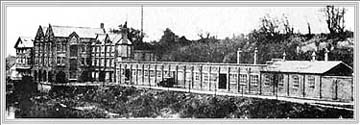
Right: This
was
the
factory
of
Messrs
T.
Nicholls,
manufacturers
of
tobacco
and
snuff,
which
was
established
here
in
the
1780s,
and
which
stood
directly
opposite
the
Groves
and
Bandstand
shown
in
the
previous
picture.
Following a fire, the
buildings
were
entirely
demolished
in
the
1960s and soon after
the
exceedingly
ugly
Salmon Leap Flats
were
built
at
the
Old
Dee
Bridge
end
of
the
site
and
the
rest
was
landscaped
and
a
footpath
to
the
Meadows
constructed.
At
the
far
end,
the Salmon
Leap itself survives
and
the
waterwheel
which
once
powered
Nicholl's
snuff
mill
has
been
restored. A small generating station now stands where a smaller tobacco works and a tallow candle works used to be on Cherry Tree Island at the end of the weir.
Right: A
delightfully
evocative
hand-coloured
photograph of
customers
enjoying
a
sunny Sunday
at
the
old White
House
Hotel which
formerly
stood
above
the
river
on
Sandy
Lane
in Boughton,
just
outside
Chester.
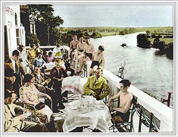 The cafe had originally been a pub. Reader Mike Lawton found this page and wrote to tell us that "my Great Grandparents Alfred and Sarah Jane Brentnall (ne Lloyd) ran the pub in the early 1900s and I had never seen a photo before. They had 7 daughters and one son (also Alfred) and apparently the girls regularly all trouped down to Hever Castle at the invitation of Lord and Lady Aster to dance at the balls. Why I have no idea. Alfred worked as a foreman for the leadworks and was found leaning on a bench outside the White House Pub. They thought he was asleep but he had died!"
The
variety
of
the
gentlemen's
clothing
in
the
photograph
is
particularly
interesting-
the
wearers
appearing
equally
comfortable
in
swimming
trunks
or
sturdy
three-piece
suit,
collar
and
tie! Sadly,
the
cafe
no
longer
exists
and
the
site
is
now
occupied
by
a
mundane
block
of
flats.
However,
Sandy
Lane
still
remains
an
attractive
area
of
the
city
and
is
very
popular
with
Chester
families,
especially
during
the
summer
months.
There
is
an
outdoor
swimming
pool,
playground,
boatyard,
sailing
club
and
a
public
slipway. You can see a photograph of the old White House in our 'lost pubs of Chester' gallery.
 During
the
summer,
there
is
a
ferry
link
with
the
vast
recreational
open
space
on
the
other
side
of
the
Dee
known
as The Meadows-
which
can
also
be
easily reached
from
the
city
side of the river
by
crossing the suspension bridge and walking
along
the
footpath
which
now
occupies
the
site
of
the
old
tobacco
factory
in
the
previous
picture- a pleasant stroll indeed.
During
the
summer,
there
is
a
ferry
link
with
the
vast
recreational
open
space
on
the
other
side
of
the
Dee
known
as The Meadows-
which
can
also
be
easily reached
from
the
city
side of the river
by
crossing the suspension bridge and walking
along
the
footpath
which
now
occupies
the
site
of
the
old
tobacco
factory
in
the
previous
picture- a pleasant stroll indeed.
A
little
further
along
the
river
from
the site of the old White House-
and
once one
of
this
writer's
favourite
summer
pubs before it was converted into an expensive bar/restaurant-
is
the Red
House,
which
boasts
superb
gardens
dropping
sharply
down
to
a
landing
stage
on
the
riverbank
and
has
splendid
views
over
the
Meadows,
River
Dee
and
the
towers
and
spires
of
the
City
of
Chester.
The nearby, still unspoiled, Mount
Inn offers
even
more
spectacular
views
over
the
'Earl's Eye', river
and
city.
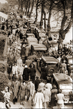
Left: A small and rather
fuzzy
view
of The Groves from
sometime
in
the
1950s,
as
viewed
from
the
Queens
Park
Suspension
Bridge. (You can see a fine photograph of the suspension bridge taken about ten
years later here).
The photograph seems to have been taken on a bright day in early Springtime-
the trees are still quite bare and everyone is well wrapped-up to enjoy
the sunshine. The cars here are bumper to bumper the full length of the
road, making life difficult for the many walkers. Who said traffic
congestion was a new problem?
 Today,
access
to
The
Groves
by
car
has
been
considerably
restricted
and
priority
rightly
been
given
to
pedestrians. If
you're
planning
to
visit,
a
limited
amount
of
parking is available,
but
if
at
all
possible,
you
should
try
to
leave
your
car
elsewhere
and
explore
the
area
on
foot.
You'll
enjoy
it
much
more
that
way!
Today,
access
to
The
Groves
by
car
has
been
considerably
restricted
and
priority
rightly
been
given
to
pedestrians. If
you're
planning
to
visit,
a
limited
amount
of
parking is available,
but
if
at
all
possible,
you
should
try
to
leave
your
car
elsewhere
and
explore
the
area
on
foot.
You'll
enjoy
it
much
more
that
way!
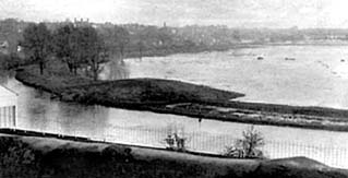
Right: The Earl's Eye flooded by the waters of the River Dee, as would
have regularly occured from time immemorial until just a few years ago,
when improved management of the river has made this view a strange one
for today's Cestrian. Or
so
we
thought-
see
below..
In Saxon times, the waters of the Dee covered the whole of this area with the exception of a small island upon which stood a stone cross, the stump of which you may still see in the middle of the racecourse today.
Even earlier, in Roman times, the river, which was then much wider and deeper, flowed right up to what is now the base of Chester's medieval city wall and their galleys moored on what has for centuries been Britain's oldest racecourse, the Roodee.. Here are some photographs of the Meadows in more peaceful mood...
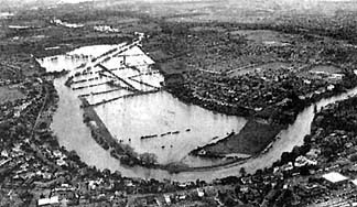 The
above
reference
to
improved
management
making
the
flooding
of
the Meadows a
rare
sight
started
to
ring
a
little
hollow
in November
2000 when
this
dramatic aerial
photograph
was
taken. Chester was by no means the most severely affected area however, as rivers
throughout Britain overflowed their banks resulting in massive damage
to homes and farmland.
The
disaster
was
blamed
upon
a
variety
of
factors
such
as
global
warming,
modern
farming
methods,
overdevelopment
of
flood
plains-
or,
less
realistically,
that
it
was
just
"one
of
those
things"...
At
the
time
of
writing,
however,
in
early December
2000,
a
mere
night
or
two
of
heavy
rain
has
once
again
resulted
in
rapidly
rising
water
levels
and
flood
alerts
are
in
place
on
dozens
of
rivers.
November 2012: Remarkably, twelve years have passed since the above was written and currently, the Dee has once again burst its banks and extensive flooding has closed roads and ruined homes throughout neighbouring North Wales...
Even worse came in February 2014, when extensive areas of the British Isles were inundated. Here is a new gallery of images of the Chester Meadows at this time...
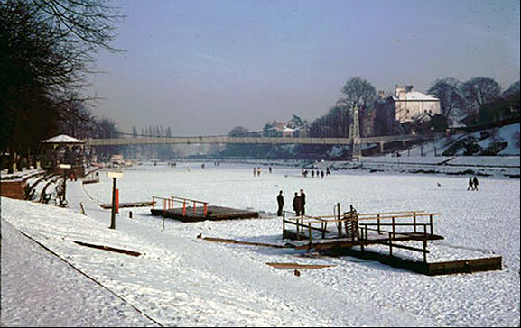
A couple of views of people walking on the frozen River Dee during the long hard winter of 1963
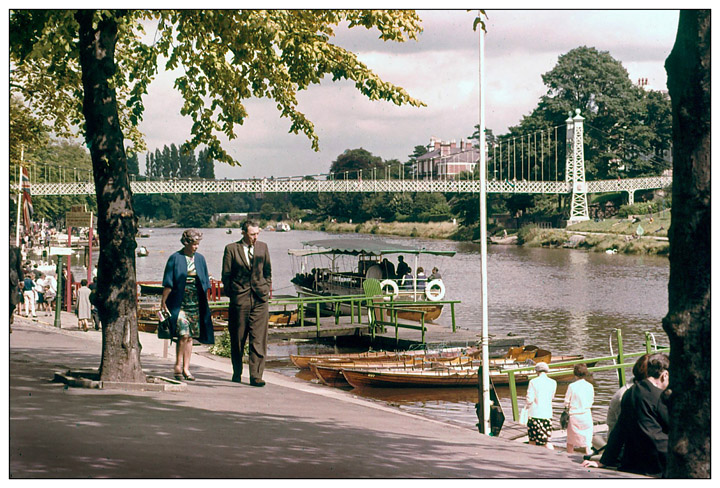
In stark contrast, here's a view of the Chester Groves on a Summer's day in the 1960s- a view that has hardly changed since.
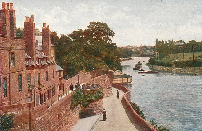
The River Dee and City Walls viewed from near the Old Dee Bridge in these lovely old postcards