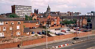
  ntil recently, as
we
walked
east
along
the
North
Wall,
we
came
once
again
to
the
chaotic
scenes
of
a townscape
in
transition.
All
trace
the
unattractive
modern
additions
to
the Chester
Royal
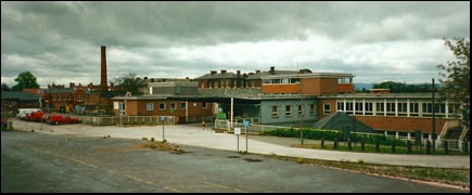
Infirmary (see our photograph below) had
vanished,
medical
services, with the exception of the City Walls GP practise,
had
moved
to
the
newer Countess
of
Chester
Hospital on
Liverpool
Road
and
work
upon
the
new
houses
was underway. By the Autumn of 2002, the radical redevelopment of this large and historic site was largely complete. ntil recently, as
we
walked
east
along
the
North
Wall,
we
came
once
again
to
the
chaotic
scenes
of
a townscape
in
transition.
All
trace
the
unattractive
modern
additions
to
the Chester
Royal
Infirmary (see our photograph below) had
vanished,
medical
services, with the exception of the City Walls GP practise,
had
moved
to
the
newer Countess
of
Chester
Hospital on
Liverpool
Road
and
work
upon
the
new
houses
was underway. By the Autumn of 2002, the radical redevelopment of this large and historic site was largely complete.
(Here, by the way, is a fascinating and extensive illustrated history of hospitals in and around Chester).
The
Infirmary
had
been
enlarged
in
1914-
the Albert
Wood
Wing being
opened
in
March
of
that
year
by
King
George
V and
Queen
Mary,
the
hospital
being
permitted
to
assume
the
title
of Royal Infirmary
as
a result
of
their
visit. Albert
Wood himself was
a citizen
of Conwy in
North
Wales-
and
a grateful
ex-patient,
who
funded
the
work
with
a gift
of £12,500.
 The hospital was extended once again to house new out-patient and accident departments,
this new section being opened on 11th June 1963 by Princess Marina, the Duchess
of Kent. The hospital was extended once again to house new out-patient and accident departments,
this new section being opened on 11th June 1963 by Princess Marina, the Duchess
of Kent.
Both of
these
extensions
have
now
vanished
as
if
they
had
never
been.
During
the
preparatory
work
for
the
construction
of
the
earliest
of
them, the eminent archaeologist, Professor Robert
Newstead undertook
an
investigation
of
the
site,
when
evidence
of
Roman
burials
came
to
light.
It is exceedingly difficult to imagine this place as recently as the middle
of the last century when Thomas Hughes wrote of it, "We see on our left hand, through the refreshing grove of trees, a large and
verdant mead, still retaining its ancient name of the Barrow Field or
Lady Barrow's Hey. This is the place where the soldiers of old Rome went
through their daily military exercises, and where, 1500 years later, great numbers
of the citizens who died of the plague were hurredly interred".
 This 'Barrow
Field' was
the
last
survivor
of
the
extensive
open
lands
lying
within
the
city
walls
that
once
lay
between
here
and
the new HQ development,
and
collectively
known
as
'The Crofts'. You can see the large area it once occupied on this detail of the 1898 Chester OS map. This 'Barrow
Field' was
the
last
survivor
of
the
extensive
open
lands
lying
within
the
city
walls
that
once
lay
between
here
and
the new HQ development,
and
collectively
known
as
'The Crofts'. You can see the large area it once occupied on this detail of the 1898 Chester OS map.
In March
1997,
it
was
announced
that
planning
permission
had
been
granted
to Bryant
Homes for
a development
of
100
homes
ranging
from
one
bedroom
flats
to
three-storey,
four
bedroom
town
houses
to
be
built
on
the
site,
and
that
three
of
the
roads
within
the
new
development
were
to
be
given
names
connected
with
Chester's
twin
town, Sens in
northern
Burgundy: The
Yonne, Brennus
Place and Sens
Close.
('Yonne' is
the
name
of
the
Department
in
which
Sens
is
situated
and
also
the
river
on
which
it
stands,
whereas 'Brennus' was
an
ancient
Gallic
warrior
and
hero
who
led
the
struggle
against
the
Romans
in
the
Sens
area). The development was designed by architects Jane Derbyshire and David Kendall.
Before building work started, a team of archaeologists undertook a 16-week
investigation of the site. Amidst the noise and clouds of dust from nearby demolition
work, they and their discoveries could be seen through observation ports in
the surrounding fencing, which had been decorated with a series of fine murals
by six local primary schools on the theme of 'Routeways to Chester through Time'.
Much
Roman
and
Saxon
pottery
was
found,
as
well
as
the
foundations
of
some
prevously-unknown
agricultural
buildings
and
features
connected
with
a Roman
cemetery.
A large
amount
of
green
and
yellow-glazed
medieval
roof
tiles
were
also
discovered,
as
well
as
later
material
dating
from
the
17th
-19th
centuries.
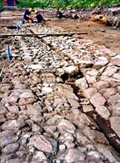
Our
photograph
below
shows
a wonderful,
previously
unrecorded,
cobbled
roadway
complete
with
central
drain,
appearing
out
of
the
mud
for
the
first
time
in
many
centuries,
which
has
been
dated
to
around
the
middle
of
the
14th
century.
Notice
how
the
section
furthest
from
the
camera
has
been
resurfaced
to
a higher
quality,
using
smaller
stones.
 A great tithe barn belonging to St. Werburgh's Abbey once stood somewhere in this vicinity- King Street opposite used to be
known as Barn Lane- and it was hoped traces of it may be discovered.
Unfortunately, this proved not to be the case and the barn's site is now surmised
to lie somewhere under the modern Inner Ring Road. A great tithe barn belonging to St. Werburgh's Abbey once stood somewhere in this vicinity- King Street opposite used to be
known as Barn Lane- and it was hoped traces of it may be discovered.
Unfortunately, this proved not to be the case and the barn's site is now surmised
to lie somewhere under the modern Inner Ring Road.
When a former nurse's home next to this road was demolished towards the end
of the dig, a 16th century pipe kiln was discovered, one of the first
to be found in the city, and now established as the oldest known in the UK-
complete with large quantities of broken pottery and clay pipes.
Tentative evidence of prehistoric occupation of the site was also found- in
an ancient place like Chester, where almost every square inch has been repeatedly
built and rebuilt upon, century after century, evidence of pre-Roman occupation
is extremely rare and finds of such ancient remains are almost unknown.
The
developers
gained
a lot
of
positive
publicity
when
they
declared
they
were
altering
their
plans
to
allow
the
road
and
other
remains
to
be
reburied
and
built
on
top
of,
thus
preserving
them
for
future
generations. But,
soon
afterwards,
they
instead
destroyed
much
of
it
by
the
laying
of
concrete
foundations.
This
writer
witnessed
the
excavator
at
its
destructive
work
while
conducting
a party
of
Australian
visitors
round
the
walls-
who
were
astonished
that
such
needless
vandalism
should
have
occured.
 But
at
least
the
original
1761
Infirmary itself-
a grade
II
listed
building-
has
been
fully
restored
to
form
an
integral
part
of
the
new
housing
development,
and
its
interior
sub-divided
into
18
'executive
apartments'.
We
saw
the
building
floodlit
at
night
in
October
2001,
just
after
the
scaffolding
had
come
down,
and
must
say
it
looked
magnificent. But
at
least
the
original
1761
Infirmary itself-
a grade
II
listed
building-
has
been
fully
restored
to
form
an
integral
part
of
the
new
housing
development,
and
its
interior
sub-divided
into
18
'executive
apartments'.
We
saw
the
building
floodlit
at
night
in
October
2001,
just
after
the
scaffolding
had
come
down,
and
must
say
it
looked
magnificent.
Planning permission had been granted to this large housing development partly upon the condition that a children's play area was constructed for the benefit of the younger new residents. As it has turned out, the sort of community this has become may be ascertained by the number of complaints which soon began to be received by the developers, to the effect that said playground "was not required or wanted". Residents also complained about paying ground rent for the planned play area and expressed the fear that it would "attract youths" (God forbid) to the area. They didn't even agree with a plan to install benches within the grounds!
As a result of all the moaning, developers Bryant Homes notified the
city council that they had been persuaded not to proceed with the playground- only to be informed that they would then be in breach of their planning permission and a limited extension of the time allowed for the completion of the work was granted. Bryant then offered to pay £15,000 towards the restoration of the nearby Water Tower Gardens if they could be released from their obligation to construct the playground and this was duly agreed by the city council planning board in October 2001.
In December
1998,
during
(archaeologically
unsupervised)
excavations
to
lay
pipes
along
the
course
of
City
Walls
Road,
workers
discovered
a pila-
a stone
pillar
which
once
formed
part
of
a Roman hypocaust,
or
central
heating
system.
It
does
not
form
part
of
an in
situ building
so
was
presumably
transported
here
for
re-use
from
the
ruins
of
a bath
house
or
substantial
private
dwelling.
One
such
existed
until
the
18th
century
in
nearby Watergate
Street and-
even
closer
to
the
Infirmary
site-
evidence
was
discovered
for
the
possible
existence
of
a Centurion's
residence
just
across
the
present Inner
Ring
Road under
the
currently-derelict
bowling
green
in Hunter
Street.
As
we
have
learned
elsewhere,
this
entire
area
is
currently
awaiting
some
form
of
redevelopment- details
of
which finally
emerged
in
July
2001-
which
hopefully
will
include
a thorough archaeological
investigation
to
confirm
this.
 To
our
left,
as
we
continue
to
move
parallel
to
the Shropshire
Union
Canal and
its
interesting
lock
system,
the
changing
landscape
around Tower
Wharf may
be
seen.
This
is
another
part
of
Chester
due
for
major
changes
in
the
near
future,
when British
Waterways pushes
through
its
controversial
development
plans for new houses, apartments, restaurants and offices. To
our
left,
as
we
continue
to
move
parallel
to
the Shropshire
Union
Canal and
its
interesting
lock
system,
the
changing
landscape
around Tower
Wharf may
be
seen.
This
is
another
part
of
Chester
due
for
major
changes
in
the
near
future,
when British
Waterways pushes
through
its
controversial
development
plans for new houses, apartments, restaurants and offices.
The
area
immediately
below
the
wall
here
is
pleasantly
wooded
and
provided
with
picnic
tables,
from
where
you
may
observe
the
canal
boats
coming
and
going
through
the
locks.
The
towpath
between
here
and
Hoole
has
recently
undergone
a
much-needed
restoration
and
is
much
more
pleasant
to
cycle
and
walk
upon
than
it
formerly
was.
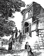
'Pemberton's
Parlour'
We
presently
come
to
a
curious
semi-circular
structure
on
our
left.
This
is
the much-altered
medieval Goblin
Tower- also once called 'Dille's Tower'-
but
more
commonly
known
today
as Pemberton's Parlour. The old Chester guide and author Thomas Hughes tells us why, "John Pemberton, ropemaker, a member of an old Chester family, about the year 1700 established a rope-walk within the Walls, between King-street and the Water Tower. It is said to have been his custom to sit under this old alcove, watching his men and boys at work in the pretty grove below. Hence arose its name, Pemberton's Parlour".
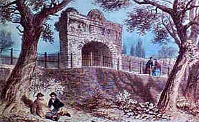
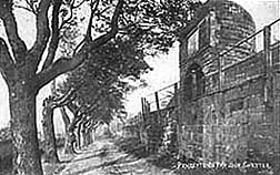
Above
we
see
the
Goblin
Tower
in
a
watercolour
of
the
1820s
and
below
in
an
old
photograph
dating
from
the
early
years
of
the
twentieth
century,
each
showing
it
flanked
by
Hughes' "refreshing
grove
of
trees",
standing
where
now
only
cars
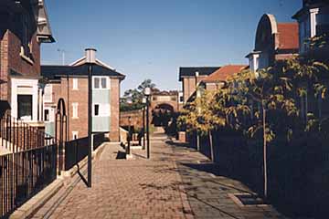
flourish. The modern photograph by the author (above) of some of the new houses near the site also shows the old tower in the background.
 The
tower
once
straddled
the
wall
as
a
completely
circular
structure
with
a
walkway
running
through
the
middle,
and
stood
twice
its
present
height.
Badly
damaged
during
the
17th
century Civil War Siege
of
Chester, it
deteriorated
until
the
early
part
of
the
18th
century,
when,
as
part
of
an
extensive
programme
of
repairs
to
the
war-damaged
walls,
the
crumbling
top
and
inner
portions
were
demolished
and
the
local
builder
and
sculptor John
Tilston rebuilt
what
was
left
into
its
present
form-
that
of
a
decorative
arbour,
complete
with
sculpted
panels
depicting
the
Royal
and
City
coats
of
arms
and
bearing
the
following
inscription: The
tower
once
straddled
the
wall
as
a
completely
circular
structure
with
a
walkway
running
through
the
middle,
and
stood
twice
its
present
height.
Badly
damaged
during
the
17th
century Civil War Siege
of
Chester, it
deteriorated
until
the
early
part
of
the
18th
century,
when,
as
part
of
an
extensive
programme
of
repairs
to
the
war-damaged
walls,
the
crumbling
top
and
inner
portions
were
demolished
and
the
local
builder
and
sculptor John
Tilston rebuilt
what
was
left
into
its
present
form-
that
of
a
decorative
arbour,
complete
with
sculpted
panels
depicting
the
Royal
and
City
coats
of
arms
and
bearing
the
following
inscription:
IN
THE
7th
YEAR
OF
THE
GLORIOUS
REIGN
OF
QUEEN
ANNE,
DIVERS
LARGE
BREACHES
IN
THESE
WALLS
WERE
REBUILT
AND
OTHER
DECAYS
THEREIN
REPAIRED.
TWO
THOUSAND
YARDS
OF
THE
PACE
WERE
NEW
FLAGGED
OR
PAVED
AND
THE
WHOLE
IMPROVED,
REGULATED
AND
ADORNED
AT
THE
EXPENSE
OF
ONE
THOUSAND
POUNDS
AND
UPWARDS
 -followed
by
the
names
of
the
Mayors
1701-8,
and
the
name
of
the
Recorder
and murengers-
the
officials
responsible
for
the
administration
of
the Murage,
a
tax
imposed
upon
goods
entering
the
city
for
the
maintainance
of
the
City
Walls. The
'divers
large
breaches'
referred
to
were
the
result
of
the
long
battering
by
Parlimentary
guns
and grenados (mortars)
during
the
bloody
siege
of
sixty
years
earlier. -followed
by
the
names
of
the
Mayors
1701-8,
and
the
name
of
the
Recorder
and murengers-
the
officials
responsible
for
the
administration
of
the Murage,
a
tax
imposed
upon
goods
entering
the
city
for
the
maintainance
of
the
City
Walls. The
'divers
large
breaches'
referred
to
were
the
result
of
the
long
battering
by
Parlimentary
guns
and grenados (mortars)
during
the
bloody
siege
of
sixty
years
earlier.
Sculptor John Tilston
also, incidentally, also created the fine statue of Queen Anne which long adorned the south front of the old Exchange in Town Hall Square. When this burned down in 1862, the statue was moved to
Bonewaldesthorne's Tower, remaining there until the 1960s, when it was, for reasons unknown, transferred to a council depot in Canal Street and from there
mysteriously disappeared, never to be seen again...
An account of a walk around the Walls, penned around the year 1706, and quoted by Hemingway, says this of the old tower, "from hence, we go still westwards, passing... a small tower formerly called Goblin's, or Dill's, since PEMBERTON'S PARLOUR, which, being ruinous, was of late half of it taken down; the other half, being a semi-circle, still remains, and, arched-over and benched round with stone, makes a very station from whence you have a fine prospect of the Crofts and the west parts of the city".
In
1894,
owing
to
the
constant
vibration
from
the
nearby
trains-
there
were
more
of
them
then-
the
Goblin
Tower
had
to
be
rebuilt
yet
again,
but
the
original
plaques,
although
somewhat
weathered
by
this
time,
were
replaced
over
the
entrance,
where
you
may,
with
some
difficulty,
still
read
their interesting
inscriptions
today.
Well recorded may be the name and activities on this spot of 18th century ropemaker and mayor John Pemberton, but the city records show that, in 1733, one Jonathan Whittell applied for and was granted, for a yearly payment of 12d, permission to use the lane "between Barn Lane (King Street) and the New Tower "to spin and make small cords and ropes". This ropewalk long survived and is shown on Hemingways map of 1829, almost a century later. Water Tower Street stands on its site today.
Whittell subsequently applied to erect various buildings in the vicinity to store tools, tar ropes etc, situated on a piece of land belonging to the city and "near to that part of the City walls known as the "Queen's Seat"- an evocative name that has sadly long vanished from use.
The Inner Ring
Road
 Passing
on,
the
increasing
noise
and
smell
of
traffic
warns
us
that
we
are
once
again
approaching
the
Inner
Ringroad
and
here
we
see
before
us
the
most
recent
breach
in
Chester's
ancient
circuit
of
walls- St. Martin's
Gate-
so
called
because
of
an
association
of
the
area
with
the
ancient
parish
of
that
name- ironically, the ancient church that gave the parish its name was demolished to make way for the road and few now remember where it stood for the best part of a millennium. Passing
on,
the
increasing
noise
and
smell
of
traffic
warns
us
that
we
are
once
again
approaching
the
Inner
Ringroad
and
here
we
see
before
us
the
most
recent
breach
in
Chester's
ancient
circuit
of
walls- St. Martin's
Gate-
so
called
because
of
an
association
of
the
area
with
the
ancient
parish
of
that
name- ironically, the ancient church that gave the parish its name was demolished to make way for the road and few now remember where it stood for the best part of a millennium.
As
the
city
grew,
and
with
the
advent
of
the
motor
car,
plans
for
a
new
road
to
take
traffic
around
the
outside
of
the
city
rather
than
though
its
ancient
narrow
streets
had
been
discussed
since
at
least
the
1940s.
One
route
proposed
at
that
time
(as
part
of
the remarkable Greenwood
Development
Plan of
1944)
sent
the
new
road
up
narrow
and
historic King
Street-
obliterating
most
of
it
in
the
process-
and
out
through
an
enlarged Northgate.
However,
in
the
1960s,
the
present,
equally
regrettable
route
was
decided
upon,
and
this
new
gateway
through
the
walls
was
designed
by
the
City
Engineers, A H F
Jiggens and Grenfell
Baines of
the
Building
Design
Partnership,
and
opened
in
1966
by
the
Minister
of
Transport, Barbara
Castle.
It
is
said
to
have
been
praised
for "its
elegance
and
combination
of
simplicity
and
lightness".
You
must
make
your
own
minds
up
about
this
from
our
photograph.
Its
appearance
is,
however,
considerably
marred
by
the
ugly
plastic
traffic
barriers
situated
directly
below.
The
Ringroad
between
here
and
the Castle occupies
the
site
of
four
old
streets: Castle
Esplanade, Nicolas
Street, Linenhall
Street and-
nearest
to
us- St. Martin's
Fields,
which
did
a
right-angled
turn
just
short
of
the
city
wall
and
joined
up
with
the
end
of
King
Street.
Here
you
can
see
a
terrace
of
fine
Georgian
houses,
the King's
Buildings of
1776,
which
stood
propped-up
and
derelict
for
years
before
eventually being
carefully
restored.
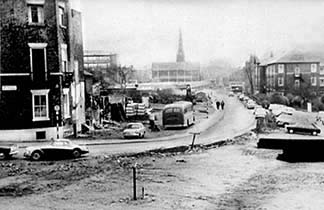
Our
photograph
shows
the
scene
in 1965, during
the
final
days
of
the
old
road-
the
King's
Buildings
are
seen
on
the
left,
the
Infirmary
nurse's
home
on
the
right.
The
demolition
of
the
entire
left-hand
side
of
the
street
is
well
advanced
and
you
can
actually
see
the
course
of
the
new
Ringroad
marked
out
in
the
mud
in
the
foreground,
heading
straight
for
the
new
breach
in
the
City
Wall. (This interesting photograph was taken somewhat earlier from a viewpoint slightly to the right and shows the buildings in St. Martin's Fields still standing).
 Compare
this
photograph
with
the
one
below,
which
shows
the
same
view
thirty
years
on,
and
the
present
mundane
collection
of
modern
structures
along St.
Martin's
Way.
The
large
and
ugly
office
block
on
the
left
has
stood
empty
for
a
number
of
years.
This,
and
all
the
land
between
it
and
the
Town
Hall-
currently
occupied
by
the
main
bus
station,
boarded-up Masonic
Hall and City
Mission and
an
ancient
bowling
green
(not
to
mention
the
Roman
and
medieval
remains
beneath)-
were
due
to
be
replaced
by
a
huge
new
retail
and
housing
development.
After
many
of
these
buildings
had
been
vacated
and
boarded
up-
and
a
great
deal
of
public
unease
about
the
scale
and
nature
of
the
project
was
expressed-
the
developers, Scottish
Widows,
chose
to
pull
out,
declaring
the
project
to
be "no
longer
viable".
The
immediate
future
of
this
large
area
of
Chester
city
centre
thus
remains,
for
the
moment,
uncertain,
although,
of
recent
months,
a
company
by
the
name
of London
&
Amsterdam
Developments is
reported
to
be
in
discussions
with
Chester's
planning
officials
about
the
site.
Go here for
further
details... Compare
this
photograph
with
the
one
below,
which
shows
the
same
view
thirty
years
on,
and
the
present
mundane
collection
of
modern
structures
along St.
Martin's
Way.
The
large
and
ugly
office
block
on
the
left
has
stood
empty
for
a
number
of
years.
This,
and
all
the
land
between
it
and
the
Town
Hall-
currently
occupied
by
the
main
bus
station,
boarded-up Masonic
Hall and City
Mission and
an
ancient
bowling
green
(not
to
mention
the
Roman
and
medieval
remains
beneath)-
were
due
to
be
replaced
by
a
huge
new
retail
and
housing
development.
After
many
of
these
buildings
had
been
vacated
and
boarded
up-
and
a
great
deal
of
public
unease
about
the
scale
and
nature
of
the
project
was
expressed-
the
developers, Scottish
Widows,
chose
to
pull
out,
declaring
the
project
to
be "no
longer
viable".
The
immediate
future
of
this
large
area
of
Chester
city
centre
thus
remains,
for
the
moment,
uncertain,
although,
of
recent
months,
a
company
by
the
name
of London
&
Amsterdam
Developments is
reported
to
be
in
discussions
with
Chester's
planning
officials
about
the
site.
Go here for
further
details...
• Years later, in July 2010, the Masonic Hall, City Mission and other historic buildings are long demolished but little else has occured, save for the entire area, closely resembling a wartime bomb site, being hidden behind hoardings, ironically bearing the logo of Chester Renaissance, and awaiting an economic climate sympathetic to continued progress. The last we heard, our masters were talking about the possibility of cobbling together a make-do 'retail led' development- eupemistic council talk meaning no new library, no performing arts centre, no cinema- the very badly-needed community-orientated features they used to convince the locals that their massively expensive development of shops nobody needs and luxury apartments nobody wants would somehow be a good thing and an asset to our historic city centre. Meanwhile, the land lies fallow, returning rapidly to wilderness, awaiting a time when common sense returns. Could be a long wait.
In
the
middle
distance,
past
the
aforementioned
vacant
office
block,
is
seen
the International (formerly The Moat
House) Hotel built
above
a
multi-storey
car
park,
behind
which
is
located
the now closed-down Gateway
Theatre amidst
an
unattractive
jumble
of
1960s
and
70s
brutalist
architecture-
and
this
writer's very
least favourite
part
of
the
city. The
crass
attempt
to
integrate
the
over-large
hotel
building
within
the
Chester
cityscape
by
the
liberal
use
of
bits
of
'stuck-on'
mock half
timbering
is
particularly
unpleasant,
and
puts
one
in
mind
of
architect
Norman
Foster's
remark about "putting
lipstick
on
a
gorilla". Its interior may be comfortable enough in an anonymous sort of way, but the area opposite the hotel's main entrance has remained, unaccountably, an unfinished concrete wasteland since the place was built over thirty years ago- hardly the vision of 'ancient romantic Chester' that many of our city's first-time visitors have been led to expect...
 Above
the
hotel
may be seen rising
the tall
19th
century
steeple
of
what
was
originally
a
Saxon
foundation, Holy
Trinity
Church in Watergate
Street (visible
in
both
pictures).
This
stands
upon
the
site
of
the
West
Gate
of
the
Roman
fortress,
the Porta
Principalis
Dextra. The
line
of
the
original,
much
narrower
streets
ran
along
the
right-hand
side
of
the
present
road-
as
we
view
the
photograph-
and
dozens
of
buildings
were
demolished
to
make
room
for
the
left-hand
lane
and
the
associated
office
blocks,
tyre
depots,
car
parks
and
suchlike
mediocre
modern
structures. Above
the
hotel
may be seen rising
the tall
19th
century
steeple
of
what
was
originally
a
Saxon
foundation, Holy
Trinity
Church in Watergate
Street (visible
in
both
pictures).
This
stands
upon
the
site
of
the
West
Gate
of
the
Roman
fortress,
the Porta
Principalis
Dextra. The
line
of
the
original,
much
narrower
streets
ran
along
the
right-hand
side
of
the
present
road-
as
we
view
the
photograph-
and
dozens
of
buildings
were
demolished
to
make
room
for
the
left-hand
lane
and
the
associated
office
blocks,
tyre
depots,
car
parks
and
suchlike
mediocre
modern
structures.
You can clearly see the original layout of the area in this detail from the 1898 Chester OS map.
The
view
as
you
stand
on
the
top
of
St. Martin's
Gate
is
certainly
interesting-
the
full
extent
of
the
North
Wall
from Bonewaldesthorne's
Tower to
our
starting
point
at
the Northgate being
visible.
On
occasions
from
here
you
may
see
barges
on
the
canal,
bicycles
on
the
towpath,
trains
on
the
railway
and,
inevitably,
cars
on
the
road
below-
all
at
the
same
time.
If
you're
not
too
bothered
by
the
proximity
of
fast-moving
traffic,
walk
a
little
way
along
the
Ringroad's
footpath
to
see
a
grand
panorama
of
the
Victorian
rooftops
in
and
around Garden
Lane and
a
fine
view
of
the
remaining
green
spaces
between
here
and
the
Clwyd
Hills
in
the
distance.
Earlier
in
our
walk,
when
we
were
at
the Newgate,
you
will
remember
how
we
temporarily
parted
company
with
the
Roman
walls,
and
I
told
you
how,
in
the
early
10th
century,
the
long-abandoned
defences
had
been
restored
and
extended
by
new
Saxon
masters
to
enclose
a
much
greater
area
of
land.
At
this
point,
we
are
now
rejoining
the
line
of
the
original
fortifications-
if
you
look
carefully
at
the
point
where
the
steps
meet
the
pavement
on
the
eastern
(city)
side
of
St. Martin's
Gate,
you
will
see
a
square
outline
of
cobbles
laid
out
in
the
pavement.
This
marks
the
site
of
the North-West
Corner
Tower of
the
Roman
fortress-
the
original
wall
having
run
south
from
here
on
the
line
of
the
ring
road
below,
to
the
now-vanished
West
Gate.
When
the
new
road
was
constructed,
a
brief
and
(as
the
official
record
phrases
it) "severely
under-resourced
opportunity
was
presented
to
to
observe
the
remains
of
an
unprecedented
length
of
the
Roman
defences,
while
the
possibilities
of
future
investigations
were severely
reduced".
The
work
was
undertaken
by Dennis
Petch,
the-then
Curator
of
the
Grosvenor
Museum.
He
was
forced
to
spend
much
of
his
career
undertaking
urgent
and
hurried
rescue
excavations
on
the
large
areas
of
the
city's
irreplaceable
heritage
then
being
deliberately-
and
often
needlessly-
destroyed.
Read
his
terse
comments
about
the
destruction
of
a
great
Roman
bath
house
on
the
site
of
the
Grosvenor
Shopping
Precinct here.
Until
the
coming
of
the
Ringroad
and
the
construction
of
St. Martin's
Gate
in
1965,
this
north-west
corner
tower,
which
was
built
around
AD103,
survived
to
a
height
of
eleven
courses
above
plinth
level-
just
a
couple
of
courses
less
than
the
height
of
the
present
City
Walls.
Everything
above
ground
level
was, unforgivably,
demolished
and
the
site,
like
so
many
of
Chester's
Roman
relics,
remains
poorly
presented-
in
this
case
hardly
presented
at
all-
the
ancient
foundations
being
completely
hidden
from
view
beneath
the
pavement.
Just
beyond
this
is
a
decent
development
of
student
flats,
newly-erected
in
a
style
sympathetic
to
the
neighbouring
18th
century King's
Buildings-
although
a
few
trees
planted
around
the
area
would
help
to
soften
the
new
buildings
and
help
to
alleviate
the
noise
and
stench
of
the
nearby busy
road.
Prior
to
this,
the
site
was
occupied
by
an
old
house
known
as 'Pemberton
Cottage' which
stood
sadly
derelict
for
many
years.
 Just
beyond,
behind
King's
Buildings
is King's
Court,
a
pleasant
and
secluded
development
of
small
modern
houses
which
provide
an
interesting
contrast
with
the
fine
17th
and
18th
century
buildings
in
King
Street. Just
beyond,
behind
King's
Buildings
is King's
Court,
a
pleasant
and
secluded
development
of
small
modern
houses
which
provide
an
interesting
contrast
with
the
fine
17th
and
18th
century
buildings
in
King
Street.
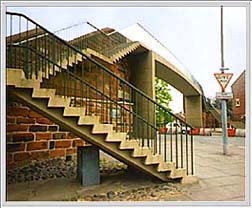
Right:
This
entire
run-down
area
between the
Inner
Ring
Road
and
the
distant Town
Hall is
due
to
change
beyound
all
recognition
in
the
near
future: here's the
details...
The
unsightly
and
long-neglected
piece
of
land
just
behind
the
King's
Buildings
and
separated
from
the
Ring Road
by
a
high
wall
(on
the
left
of
the
above
photograph)
is
apparently
soon
to
have
four
three-storey
houses
built
upon
it,
despite
the
plan
being
refused
by
the
city
council
planning
board
on
the
grounds
that
"the
outlook
from
King's
Buildings
would
be
destroyed-
it
would
create
a
tenement
effect".
A
government
inspector
disagreed,
however,
saying
that
in
this
part
of
Chester,
"a
more
intensive
degree
of
development
is
appropriate" and now, in June 2004 the new buildings are half complete and appear to be pleasingly in keeping with their Georgian neighbours. A problem developed, however, as the new building were apparently erected directly over a water main, and, ten years later, Spring 2014, the development remains scruffily unfinished and unoccupied...
And
now, gratefully
leaving
the
Ring
Road
behind
us,
we
embark
upon
our
final
short
stroll
back
to
our
starting
point,
but
first
pausing
to
consider
the Bridge
of
Sighs..
Curiosities from Chester's History no. 26
- 1801 The Act of Union between Great Britain and Ireland comes into force. The Union Jack becomes the official flag. Burglars Thompson, Morgan and Clare became the last criminals publicly executed at Boughton. When approaching the gallows, Clare, a "comely young man of twenty years" sprang from the cart and made a dash for freedom, the surprised crowd making way for him. Rolling down a steep incline, he plunged into the River Dee and was drowned, weighed down by the weight of his chains. A search was made and his body was recovered and eventually hung up with the other two malefactors, who had been kept waiting in the cart in the interval. In the same year, Aaron Gee and Thomas Gibson were hung by being pushed out of windows in the attics on the south side of the Northgate Gaol. Dropping just forty inches, their bodies "beat against the windows beneath so as to break the glass in them".
- 1803 The Bull Bait at the High Cross was prohibited by Act of Parliament, but moved to Boughton Heath- just outside the city's jurisdiction. The Pentice at the High Cross- Chester's first Town Hall- was taken down in order to widen Northgate Street.
- 1804 Napoleon is proclaimed Emperor and crowned before the Pope in Paris
- 1805 Nov 9th The city illuminated in consequence of Nelson's victory at Trafalgar on Oct 21st. Parry and Truss's coach manufactory burnt down. The Pillary was used for the last time, and together with the Stocks and Whipping Post, were removed.
- 1806 July 28th. Dreadful storm in Chester- the mast of a ship at Crane wharf shivered to pieces by lightning. Aug 24th. Joseph Crofts, the City Beadle, while conducting a runaway apprentice to the house of correction at the Northgate, was pushed down the steps there, and fractured his skull, so that he died on the Wednesday. Sept 24th. Loss of the King George packet off Hoylake, in this port, with 170 passengers on board; only 4 sailors and the steward saved.
- 1807 The slave trade abolished in England; the following year, the US prohibited importation of slaves from Africa.
- 1808 The last of the medieval City Gates, the Northgate was demolished, when remains of the Roman Porta Decumana was discovered. The gaol was moved to City Walls Road, the present site of the Queen's School. The architect of the new Northgate, Thomas Harrison, was also responsible for the Commercial Newsroom (no 1 Northgate Street) which opened this year.
- 1809 May 6th. Execution of William Proudlove and George Glover at the 'New Drop'- a gallows situated outside the House of Correction in Northgate Street, designed to temporarily replace the former site at the recently-demolished Northgate Gaol- for wounding an officer of excise. When the drop fell, the ropes broke and they fell to the ground in a state of half-strangulation. Soon after, they were taken to the drop again, and other ropes being procured, they were hung up effectually. Abraham Lincoln born
- 1810 The Northgate was rebuilt, paid for by Robert, Earl Grosvenor. The last ship- an Irish linen carrier- to call at the Port of Chester did so this year. The Wesleyan Methodist Chapel in St. John Street built. In this census year there were 17,472 people living in 3,296 houses. The Chester United Gas Company opens in Cuppin Street; gas laid to houses in 1817 and to street lights in 1819.
- 1811 King George III becomes insane; the Prince of Wales becomes Prince Regent. Luddites destroy industrial machinery in Northern England. Charles Dickens and Robert Browning born. Parry and Truss's coach works burnt down for the second time.
- 1812 Great number of Luddites brought to the Castle.
- 1816 Anne Moore, the celebrated 'fasting woman', confined in the Castle, for a robbery at Stockport; during her confinement she miraculously recovered her appetite. Aug 14th. Edith Murray and John Lomas tried and convicted of murdering the husband of the former. Aug 21st. Execution of Lomas. The execution of Murray was postponed, she pleading pregnancy.
- 1813 In this year there were 670 births, 320 marriages and 407 deaths. April 23rd. Edith Murray, being delivered of her child, was executed for the murder of her husband. She met death with "great hardihood." June 26th. Execution of three men for a rape on Mary Porter at Weston Point, Runcorn.
- 1814 Sept. George Post, who had been convicted by false witness of highway robbery, and was to have been executed, received a free pardon.
- 1815 Napoleon leaves Elba; defeated by Wellington and Blücher at Waterloo; abdicates for second time and is banished to St. Helena. Eruption of Sumbawa volcano in Indonesia causes over 50,000 deaths
- 1817 The Chester United Gaslight Company was formed and gas lighting was introduced into the streets. First grandstand built on the Roodee.
|