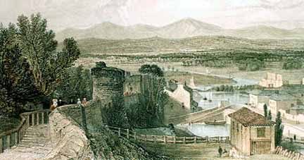
  tanding atop St. Martin's Gate, we pause awhile to look back and compare what we see with this fine view by Thomas Allom (1804-72) which was created before 1846 when the Holyhead railway cut across the scene and punched its way through the corner of the city walls. (see a picture of it here). tanding atop St. Martin's Gate, we pause awhile to look back and compare what we see with this fine view by Thomas Allom (1804-72) which was created before 1846 when the Holyhead railway cut across the scene and punched its way through the corner of the city walls. (see a picture of it here).
Ahead of us we can see the Goblin Tower and behind it, the colourfully-named Bonewaldesthorne's Tower. To the right of this, the white building was Chester's first public baths and washhouse,
established
here
in
1849.
Their founders, a committee of private citizens, had obtained a grant of over £1000 from the council, together twith the lease of this plot of land. The new baths used water from the nearby canal and access from the City Walls was via a new opening and set of steps, which survive today.
They were established- at a time when to have an indoor bathroom was an unimaginable luxury for most of Chester's people- to improve the health, comfort and habits of cleanliness and to "counteract the prevalence of contagious disease". Six thousand people turned up for the bath's opening.
The council took it over in 1850 and five years later the wash house was closed, althought the swimming and slipper baths remained popular, around seven hundred people per week using them. Admission was a penny before 8am and after 5pm but rose to 6d during the day. In 1856, the Chester historian Thomas Hughes wrote of it, "a capacious swimming bath, where plebeians may indulge in a plunge for a penny, and where hot and cold shower and vapour baths are at the service of the public".
In 1857, the Cheshire Militia from the Castle were invited to use the baths "in companies of fifty or sixty" and the water was heated for them at the cost of one penny per man. According to the long-defunct Cheshire Observer, "the men refreshed themselves with a refreshing and cleaning once a week and the advantages of bathing were apparent from their appearance".
The baths remained busy until the early 1870s, when their growing shabbiness, the declining quality of the canal water used and their increasing loss of income became more and more apparent. The Observer again, in 1876: "the present public baths are a scandal. A more cheerless, forbidding place could hardly be found, except in some of the cellars underneath the Rows. The water is supplied from the canal after it has received an appreciable proportion of the city's sewage".
The old baths closed for good soon after a revolutionary new floating bath was opened on the River Dee in 1877 and no trace remains of them today.
Opposite the baths, on the right of the picture, are the 18th century warehouses and administrative buildings of the canal company- that on the left is now a popular bar/restaurant and Chester's finest live music venue, Telford's Warehouse on Tower Wharf. Beyond, sailing ships may be seen on the canalised River Dee, making their way to and from the Old Port through a rural landscape down to the sea. In the background lie the Clwyd Hills of North Wales, of which more below.
This detail from John McGahey's splendid View of Chester from a Balloon shows more clearly how this area as it appeared at this time.
The modern visitor may be disappointed to find that the spectacular view of 150 years ago has since been considerably curtailed by the many tall trees that now grow close to the City Walls and that the woods and fields in the middle distance have been largely replaced by houses, commerce and industry. It remains nontheless a fascinating area where the ancient and the modern blend in a particularly dramatic manner.
Morgan's Mount
Descending from St. Martin's Gate, we enter the homeward stretch of our epic journey. Leaving the noisy Inner
Ringroad behind us, you will notice the wall's dramatic uphill incline which
continues until we arrive back at our starting place, the Northgate-
the highest point on the ancient walls of Chester.
This evocative old postcard, taken on a hot summer's day sometime in the 1960s, shows the view at this point. It is almost completely unchanged today.
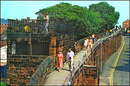 On our left we see a distictive square tower with steps leading to a platform on the top. This is known as Morgan's Mount, named after one Captain Edward Morgan, a Royalist officer in charge of an important battery of guns said to have been stationed on top of the tower during the Civil War- though it is likely that this was situated on a small hill nearby, which disappeared during the construction of the Chester Canal in the 1770s, the tower itself being used as an observation platform to direct the fire. On our left we see a distictive square tower with steps leading to a platform on the top. This is known as Morgan's Mount, named after one Captain Edward Morgan, a Royalist officer in charge of an important battery of guns said to have been stationed on top of the tower during the Civil War- though it is likely that this was situated on a small hill nearby, which disappeared during the construction of the Chester Canal in the 1770s, the tower itself being used as an observation platform to direct the fire.
Of this Captain Morgan we know little except that, during the conflict he was sometime resident at Wepre Hall near Connah's Quay in North Wales, and that he was later murdered- the unfortunate officer's body being found in an unmarked grave at the edge of a marsh near Llanasa.
(The old hall has now gone, replaced by the visitor centre of the lovely public open space, Wepre Park- Parc Gwepra in Welsh).
There is a little room within Morgan's Mount with a stone bench and windows fitted with iron bars. Early guide books wax lyrical regarding the views obtainable from this place, for example: "From the summit we have a wide-spreading and enchanting prospect, which is seldom surpassed; exhibiting the windings of the Dee to its estuary, Flint Castle, the Jubilee Column on Moel Fammau (see below), the lighthouse on the Point of Air, the beautiful range of the Clwydian Hills and the church and castle of Hawarden. Stretching away to our left is the Hundred of Wirral, the foreground dotted here and there with a handsome mansion or substantial farm house... the view embraces a rural district of more than a dozen miles in length".
 Until recently, the visitor could ascend a flight of steps to the roof of Morgan's Mount, from where the best view could be obtained, but this is, for the moment, sadly no longer possible as work is being undertaken to restore and strengthen the old structure. However, as previously mentioned when we viewed Thomas Allom's view at the top of the page, the great increase in the height of surrounding buildings and trees has restricted the prospect considerably and none of the above mentioned being now visible except for those ice-carved hills- and the best view of them in Chester is still to be had from the rising section of wall approaching the Northgate, just a little way ahead of us. Until recently, the visitor could ascend a flight of steps to the roof of Morgan's Mount, from where the best view could be obtained, but this is, for the moment, sadly no longer possible as work is being undertaken to restore and strengthen the old structure. However, as previously mentioned when we viewed Thomas Allom's view at the top of the page, the great increase in the height of surrounding buildings and trees has restricted the prospect considerably and none of the above mentioned being now visible except for those ice-carved hills- and the best view of them in Chester is still to be had from the rising section of wall approaching the Northgate, just a little way ahead of us.
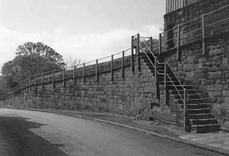
Below we see an interesting photograph of the City Wall from Morgan's Mount before the entire section on the left of the picture vanished to make way for the Inner Ring Road which punched through the ancient circuit here via a brand new entrance, St Martin's Gate. Previous to this, the road we see in the picture, Water Tower Street, which exactly follows the course of the intervallum road of the Roman fortress, proceeded all the way to the Watertower on the north-west corner of the Walls. The venerable, pre-Ring Road, layout of the area may been seen in numerous old maps, such as this one, dating from the 1920s.
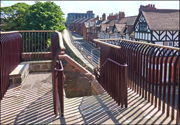
 In 2012, Morgan's Mount underwent a radical programme of restoration and the stretch of City Wall between it and the Northgate had to be closed for some months to accomodate the work. Both wall and the upper platform of the tower have recently (August 2012) re-opened to the public. Masonry has been cleaned or replaced, new timber window frames and stout door have been added to the lower chamber, smart new railings adorn the upper platform, in addtion to an interesting information panel featuring Thomas Allom's 19th century painting (see above) and some history of the monument's role in the Civil War in the 17th century and during the building of the canal below in the 18th. Our photograph shows the fine view, looking east from the top of the newly-restored tower. In 2012, Morgan's Mount underwent a radical programme of restoration and the stretch of City Wall between it and the Northgate had to be closed for some months to accomodate the work. Both wall and the upper platform of the tower have recently (August 2012) re-opened to the public. Masonry has been cleaned or replaced, new timber window frames and stout door have been added to the lower chamber, smart new railings adorn the upper platform, in addtion to an interesting information panel featuring Thomas Allom's 19th century painting (see above) and some history of the monument's role in the Civil War in the 17th century and during the building of the canal below in the 18th. Our photograph shows the fine view, looking east from the top of the newly-restored tower.
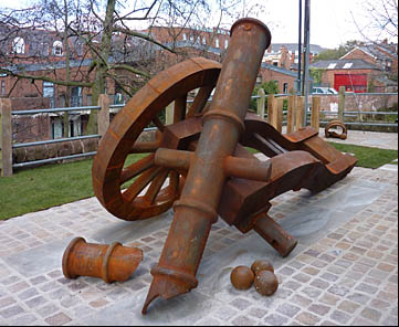
In March 2013, this remarkable sculpture of a broken cannon appeared in a newly-landscaped area at the base of Morgan's Mount.
Its artist and title are as yet unknown but we will add the details when we know them..
Moel Famau
Depending
upon
weather
and
light
conditions,
these
Clwyd
Hills
can
appear
very
close
and
dramatically
beautiful,
especially
at
sunset-
or
simply
not
be
visible
at all, lost in the clouds. Some
four
hundred
million
yeas
ago,
a
warm
shallow
sea
covered
this
region
and
now
prehistoric
shales
from
that
sea
form
the
interior
of
a
mountain
range
that
was
once
higher
than
the
(much younger) Rockies!
The
Clwyd
hills
we
see
today
are
mere
shadows
of
their
former
selves,
having
been
worn
down
over
the
aeons
by
the
action
of
ice,
rain
and
wind
along
the
length
of
the
Vale
of
Clwyd
fault
and
glaciers
cut
out
the cwms and
valleys
through
which
our
modern
roads
now
pass.
 Regarding
the
name
of
the
most
prominent
hill,
which
stands
1820
feet
(554 m) above
sea
level,
traveller
and
novelist George
Borrow,
writing
in
the
1850s,
recalled, "As
I stood
gazing
upon
the
hills
from
the
wall,
a ragged
man
came
up
and
asked
for
charity.
"Can
you
tell
me
the
name
of
that
tall
hill?"
said
I,
pointing.
"That
hill,
sir,"
said
the
beggar,
"is
called Moel
Vamagh;
I ought
to
know
as
I was
born
at
its
foot". "Moel"
said
I,
"a
bald
hill; Vamagh,
maternal
or
motherly.
Moel
Vamagh,
(now
more
usually
spelt
Famau)
the
Mother
Moel".
"Just
so,
sir,"
said
the
beggar;
I see
you
are
a Welshman
like
myself"
(Borrow
was
actually
an
Englishman
from
Norfolk
and
had
taught
himself
Welsh
as
a young
man)-
"Moel
Vamagh
is
the
Mother
Moel,
and
is
called
so
because
she
is
the
highest
of
all
the
Moels". Regarding
the
name
of
the
most
prominent
hill,
which
stands
1820
feet
(554 m) above
sea
level,
traveller
and
novelist George
Borrow,
writing
in
the
1850s,
recalled, "As
I stood
gazing
upon
the
hills
from
the
wall,
a ragged
man
came
up
and
asked
for
charity.
"Can
you
tell
me
the
name
of
that
tall
hill?"
said
I,
pointing.
"That
hill,
sir,"
said
the
beggar,
"is
called Moel
Vamagh;
I ought
to
know
as
I was
born
at
its
foot". "Moel"
said
I,
"a
bald
hill; Vamagh,
maternal
or
motherly.
Moel
Vamagh,
(now
more
usually
spelt
Famau)
the
Mother
Moel".
"Just
so,
sir,"
said
the
beggar;
I see
you
are
a Welshman
like
myself"
(Borrow
was
actually
an
Englishman
from
Norfolk
and
had
taught
himself
Welsh
as
a young
man)-
"Moel
Vamagh
is
the
Mother
Moel,
and
is
called
so
because
she
is
the
highest
of
all
the
Moels".
(In
his
most
famous-
and
still
easily
available-
work, Wild
Wales (1854)
Borrow
mentions "an
old
inn
in
Northgate
Street".
This
was
the Pied
Bull which
we
visited
in
the Northgate chapter
at
the
very
start
of
our
tour-
and
where
we
also
read
his
unflattering description of
the
Cheshire
cheese
and
ale
served
to
him
there!)
A note
appended
to
Thomas Pennant's Tours of
1883
provides
us
with
another
interpretation
of
the
mountain's
name: "The
proper
spelling
is
no
doubt Moel
Fammau-
the
Mother's
Mountain-
the
ladies
in
question
being
of
the
divine
Matres,
once
worshipped
by
the
Celts,
especially
in
Gaul.
In
Celtic
mythology,
fairies
and
goddesses
were
called mothers,
hence
'Mother's
Mountain':
the
mountain
where
the
fairies
live..."
Around
3500
years
ago,
the
slopes
of
Moel
Famau
were
used
as
sacred
burial
grounds
by
the
people
of
the
Middle
and
Late
Bronze
Age:
the
'Beaker
People'
who
succeeded
the
Neolithic
tribes.
Indeed,
for
thousands
of
years,
trade
routes
have
followed
the
passes
between
the
Clwyd
Hills
and
many
ancient
tribes
have
lived
on
the
mountain
slopes
above
the
groves
of
oak
and
hazel
that
formerly
grew
there
in
great
profusion.
 (These
have
now
largely
given
way
to
the
great
areas
of
conifers
that
make
up
the
Clwydian
Forest
managed
by
the
Forestry
Commission) (These
have
now
largely
given
way
to
the
great
areas
of
conifers
that
make
up
the
Clwydian
Forest
managed
by
the
Forestry
Commission)
In
later
centuries,
the
Roman
occupants
of
Deva
traded
with
local
tribes
for
the
lead
which
occurs
abundantly
in
the
limestone
of
the
Clwyd
Hills.
The
next-highest
hill
of
the
range
is Foel
Fenlli,
named
after
a great
Celtic
warrior-king, Benlli
Gawr,
who
was
buried
on
Goblin
Hill near the pretty market town of Mold (Yr Wyddgrug),
and
from
where, in 1833,
was
excavated
his
great golden
cape-
dating from about 1900-1600 BC and now
the
most
celebrated
exhibit
in
the British
Museum's Celtic
display.
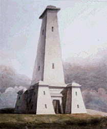
Left: This watercolour of the Jubilee Tower which once stood on top of Moel Famau is by Moses Griffith (1747-1819).
At
least
thirty
five
hut
circles
have
been
found
on
this
companion
to
Moel
Fammau,
together
with
ancient
potsherds
and
Roman
coins.
About
a thousand
yards
to
the
west,
on
a spur
at
1115
feet,
is Moel
y Gaer,
an
iron
Age
hillfort,
on
which
a double
circle
of
ramparts
can
clearly
be
seen,
enclosing
some
six
acres
of
hilltop.
The Jubilee Tower on top of Moel Famau which was built in 1810 to commemorate the 50th year of the reign of George III, was designed by Thomas Harrison, the architect who was responsible for many of the best buildings we have seen during the course of our stroll, including the Grosvenor Bridge, Castle and the Northgate- which we are now approaching and from where the best view of the hill is obtained.
The design of Harrison's 'Egyptian-style' tower was disliked by many contemporaries; the poet Gerard Manley Hopkins described it as "An ugly and trumpery construction, make-believe massive, but so frail that it was blown over... it cumbers the hilltop and interrupts the view".
 When the tower's foundation stone was laid by Lord Kenyon on 25th October 1810, around 5000 people made the arduous walk to the summit to attend the ceremony and commemorative sermons were preached at Mold and Ruthin before the clergy and gentry rode to the top on horseback "attended by musicians and beautiful women". Fat oxen and lambs were roasted and distributed to the poor of the district and the cwru da ('good ale') flowed freely all day... When the tower's foundation stone was laid by Lord Kenyon on 25th October 1810, around 5000 people made the arduous walk to the summit to attend the ceremony and commemorative sermons were preached at Mold and Ruthin before the clergy and gentry rode to the top on horseback "attended by musicians and beautiful women". Fat oxen and lambs were roasted and distributed to the poor of the district and the cwru da ('good ale') flowed freely all day...
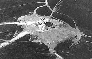
This unusual view of the summit- photographed from a microlight aircraft by your guide, showing the remants of the Jubilee Tower on top of Moel Famau and the eroded network of footpaths leading to it.
The 115 foot high tower was never finished and collapsed during a great storm (some say earthquake) on 1st November 1862. Half-hearted rebuilding attempts were made in 1863 and 1887 but never completed, but in 1970- Conservation Year- some restoration of the surviving tower base was undertaken, including the addition of a series of plaques indicating the various distant places which may be seen from this wonderful observation platform- weather allowing, it is possible to see the Isle of Man, and much of the North West of England such as Liverpool, Manchester, Winter Hill, Blackpool Tower and Cumbria.
Four years later, in 1974, the entire mountain was designated a Country Park, covering 2000 acres and permanently open to the public, and today the nipple-like appearance of the remaining tower stump atop the smooth hill continues to remind us of the 'motherly' aspect of its ancient Celtic name.
Two Welsh counties share claim to the peak of Moel Famau since the border between Denbighshire and Flintshire runs through the middle of it.
Go on to the end of our journey and part II of the Bridge of Sighs...
 Curiosities from Chester's History no. 27 Curiosities from Chester's History no. 27
- 1818 Thomas Harrison restored part of the South Transept
and added the corner turrets to the Cathedral.
All Chester's houses were numbered and the lanes were then called streets.
Seller Street was laid out by Alderman Seller. Eastgate, Northgate and Bridge
Streets, and St. Peter's Church were lit by gas.
- 1819 A dreadful fire at the Dee Mills; one life lost and
the whole fabric, with its contents consumed at estimated cost of £40,000.
- 1820 George III, after a reign of 60 years, died and the
Prince Regent came to the throne as George IV (1762-1830). As General Grosvenor was driving
home from an electioneering meeting in Chester, his political opponents cut
his horse's harness as he approached the Dee Bridge, and threw the carriage
over the parapet into the river. The General escaped injury and was taken
by his friends to the Bear and Billet Inn.
- 1821 Old Lamb Row, in Bridge Street, collapsed into the road,
but nobody was injured. It had been built as the home of Randle Holme but
then became a tavern under "the Sign of the Lamb". (see our feature on The Olde Lamb here). A Roman altar was unearthed
in Boughton (on land later known as the 'Cherry Orchard') inscribed "To the
Nymphs and Fountains- XXth Legion, the Invincible and Victorious". It was
appropriated by the Marquis of Westminster and placed in a specially-built 'temple' in the
grounds of Eaton Hall, where it remains to this day. Population of Britain: 20.8 million. Population of
US: 9.6 million
- 1822 June 29th. The steam boiler belonging to Mr Boult, a
tobacco manufacturer in Cuppin Street, burst. The explosion was terrific;
a considerable portion of the premises were laid in ruins, and the windows
of adjoining houses were shattered. Mr. Boult and three of his men were so
dreadfully injured that they all died in a few days afterwards.
- 1823 Feb 24th. The coach manufactory of Mr. Parry, in Foregate
Street, for the third time with all its contents, completely destroyed by
fire. The Monroe Doctrine closes the American continent
to colonial settlement or other interference by European powers. Mexico becomes a republic.
- 1824 Batenham records that the streets were still pebblestoned
and "a most intolerable grievance". June 7th. Mr. Sadler ascended in his balloon
from the Castle yard and descended near Utkinton. June 28th. A party witnessing
a regatta at the Lower Ferry on the Dee, being somewhat elated with liquor,
ran their boat violently against another vessel. The boat instantly upset
and thirteen of the party were drowned. Sept 2nd. Mr. Parry's coach manufactory
destroyed by fire for the fourth time... The RSPCA founded in London.
- 1825 June. The Act for erecting the new
bridge over the River Dee passed by both houses of Parliament. The Grosvenor
Bridge Commission paid £4,000 for old St. Briget's Church and its site, which
was demolished to make way for a new access road- today's Grosvenor Street.
St. Briget's was rebuilt in St. Martin's Ash, Nicolas Street the following
year- but in turn was demolished to make way for the Inner Ringroad in the
1960s. Horse-drawn buses in London...
|