|
  fter
leaving
The Phoenix
Tower behind us,
we
turn
the
corner
and
head
southward
along
the
East
Wall
which,
from
here all the way
to
the Newgate continues
to
follow
the
original
Roman
course. fter
leaving
The Phoenix
Tower behind us,
we
turn
the
corner
and
head
southward
along
the
East
Wall
which,
from
here all the way
to
the Newgate continues
to
follow
the
original
Roman
course.
Beyond
the
trees
on
our
left,
notice
how
the Shropshire
Union
Canal leaves
the
shelter
of
the
walls
and
continues
on
its
way
towards
the
pleasant suburb
of Hoole and
on
into
rural
Cheshire.
The
opening
of
this
stretch
of
canal
was
recorded
in
the
long-defunct local newspaper, the Chester
Courant, of
Tuesday,
27th
December
1774
as
follows: "Near
Cow
Lane
Bridge
(which
you
should
be
able
to
see
to
your
right
from
the
wall)
was
launched
a
large
barge,
called Egerton,
70
feet
long,
14
feet
wide
and
70
tons
burthen.
Immediately
after,
she
proceeded,
full
of
people
with
french
horns
etc
playing
on
board,
under
the
walls
of
the
city,
along
by
the Phoenix
Tower,
thro'
the
rock
that
has
been
cut
open
at
the Northgate,
to
the
dam
at
the
end
of
the
canal
now
finished,
being
about
200
yards
to
the
westwards
of
Northgate,
where
several
cannon
were
fired.
From
thence
she
was
conducted
thro'
six
bridges
and
five
locks
now
erected
on
the
Christleton
quarry;
and
afterwards
was
re-conducted
to Cow
Lane
Bridge".
Cow Lane
Bridge
was
brand new when these events took place, having been constructed to span the new canal. It was rebuilt
and
enlarged
in
the
1960s
with
the
coming
of
the Inner
Ringroad. The restaurant
and
shopping
development
next
to
it-
on
a
site
formerly
occupied
by
a
timber
yard
and
wharf-
appeared
at
this
time
also.
 This remarkable
aerial
view-
a
detail
from
John
McGahey's
famous View
of
Chester
from
a
Balloon- shows
the
old
Cow
Lane
Bridge
and
its
surroundings
as
they
appeared
around
1855. This remarkable
aerial
view-
a
detail
from
John
McGahey's
famous View
of
Chester
from
a
Balloon- shows
the
old
Cow
Lane
Bridge
and
its
surroundings
as
they
appeared
around
1855.
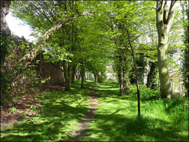
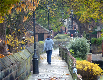
Left: Walking Chester's East Wall on a crisp Autumn day in 2014
In
earlier
times,
the
spot
where
the bridge
now
stands
was
occupied
by
one
of
a
series
of
outlying
defensive
gates,
known
as
'the Cow
Gate',
which
suffered
serious
damage
during
the
Siege
of
Chester
in
the
Civil
War. All trace seems to have been obliterated when the Chester Canal was built here in the 1770s. It was, however, still standing when Alexander de Lavaux made his map of Chester thirty years earlier, in 1745.
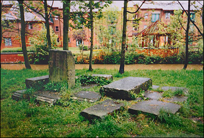
On
our
left,
some
wooden
steps,
loosely
modelled
on
Roman
originals,
take
us,
via
a
curious
selection
of
old
carved stones
(relics of the stomemason's yards that long existed here) set
in
a
pleasant wooded
area,
down
to
the
canal
bank.
The
towpath, not just
hereabouts but throughout the area, after a spirited public campaign
underwent
a
long-overdue
programme
of
restoration
and
resurfacing
and
is
very
much
more
convenient
to
stroll
or cycle along
than the muddy morass
it
formerly
was.
Trees
have
been
pruned
and
new
lighting
added.
You
should
definitely,
time
allowing,
take
the
short
stroll
from
here
to
examine
the
City
Walls
from
the
bottom
of
their
ancient
defensive
ditch,
then
pass
under
the Northgate to Tower
Wharf-
which
we
will
be
visiting
towards
the
end
of
our Virtual
Stroll.
(Some
interesting
photographs
of
Chester's
canal
as
it
appeared
during
the
1950s
and
60s
may
be
seen here and you can learn more about the canal a little further on, in the direcion of Hoole and Boughton here).
At this point, it is necessary to update a little of the above information for, in May 2003, those aforementioned curious- and rather attractive- old stones were removed by the council, apparently to prevent 'undesirables' from sitting
on them. That we ordinary citizens also enjoyed using them for a picnic or a bit of a breather didn't seem to count for much in the decision.
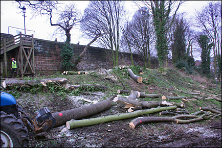
More drastically, as recently as March 2015, numerous trees in the little wooded area was cut down, also largely on the premise that the area was the haunt of 'undesirables'- a spokesman from Chester Renaissance, the body responsible for the work, informed us that "terrible things went on the area" and that "something had to be done about it".
During over twenty years of passing this way on an almost daily basis, the most terrible thing we ever observed here was the odd gentleman indulging in a beer or two among the trees.
The work was carried out, they claim, after extensive consultation with, and with the blessing of, local residents, councillors, the police and council wildlife and tree officers.
"We inspire people up and down the country to visit woods, plant trees, treasure wildlife, and enjoy the overwhelming benefits that woods and trees offer to our landscape and lives. Life's better with trees!" The Woodland Trust.
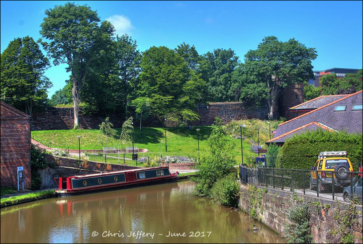
By a couple of years later, however, the newly-landscaped park had settled in and is widely acknowledged to be a great improvement and to have become a welcome addition to Chester's green spaces. Here we see it in June 2017, beautifully photographed by Chris Jeffery..
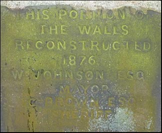
In
July
1828,
during
a
violent
rainstorm,
some
15
yards
of
of
this
stretch
of
City Wall
fell
down
into
a
ropewalk
below
and
had
to
be
rebuilt
(in
a
different
style- the
repaired
section
remains
clearly
visible today).
The Chester Courant reported upon the storm, "unequalled in the memory of the oldest, inhabitant of the city", as follows:
"The Tower Field (near the Watertower) was completely under water, and the crops will be utterly destroyed. In this city all Eastgate-street was under water on Saturday, and an impetuous current, almost sufficient to float the fleet of the Yacht Club, ran through the Eastgate! On Sunday morning the weather cleared up, and the view from the Walls at the top of the Northgate was highly picturesque; while at the same time it could not fail to give rise to melancholy reflection when taken as a specimen of a general devastation committed by the floods. All the farms on the right bank of the river, from the Sluice House and its vicinity inclusive, were completely under water, and the hedge rows, and clumps of trees gave them the appearance of a vast lake, thickly studded with clusters of green islands. The Parkgate-road was rendered utterly impassable, and the meadows in that direction all the way up to the rear of the new Lunatic Asylum were completely inundated."
The rebuilding of the City Wall following this disaster
seems
to
have
removed
all
traces
of
the
13th
century Sadler's
Tower,
the
base
of
which
survived
here
(as
still
does
that
of
the Drum
Tower,
which
we
will
encounter
later)
when
the
rest
of
the
tower
was
demolished
fifty
years
earlier.
 However, John Seacome's Chester Guide, published around 1828, tells us that, "The Sadler's Tower was taken down in 1780; and the abutment, being the occasion of a great nuisance to the residence of Griffith Rowlands Esquire immediately opposite, from the number of idle and disorderly characters who were in the habit of congregating there of an evening, that gentleman obtained permission from the Corporation to take it down and continue the wall at his own expense, in February 1828". However, John Seacome's Chester Guide, published around 1828, tells us that, "The Sadler's Tower was taken down in 1780; and the abutment, being the occasion of a great nuisance to the residence of Griffith Rowlands Esquire immediately opposite, from the number of idle and disorderly characters who were in the habit of congregating there of an evening, that gentleman obtained permission from the Corporation to take it down and continue the wall at his own expense, in February 1828".
This Griffith Rowlands was a surgeon who practised in Chester and who died in May 1828, a few months after obtaining permission to remove the venerable remains adjoining his property and before the work was completed.
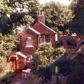
Actually, the foundations of the old Sadler's Tower are said to lie beneath the gardens of the attractive brick cottage we see on the right. Built in the early 19th century, it is the sole survivor of a group of similar houses which formerly stood here and which may just be seen in the McGahey aerial view mentioned above. Originally occupied by a stonemason employed in the adjoining works next to the canal, it has since been used for a number of diverse purposes, including cafe, massage parlour- and, until recently, as a contemporary art gallery. But, at the time of writing, the premises have recently become home to a hairdressers and, sadly, much of the period charm of the house and garden is no more.
Reader Sue Johns wrote to tell us that, as a young girl, she remembered that another, smaller cottage once stood next door to this one. It was dark and dilapidated and she recalled that she was scared of it, considering it rather a 'haunted house'. Next door again to this was a stonemason's yard, the access to which was via a gateway that still exists today, albeit firmly nailed closed and leading to nothing but a modern car park. In this yard, just inside the gate, she recalled being shown a small memorial stone, upon which was inscribed "Dedicated to my dog Spot, killed by a diabolical Welchman".
Was poor Spot the stonemason's dog? What caused the 'diabolical Welchman' to do what he did? We'd love to hear from anyone who remembers the stone or who can tell us more about it..
 An anonymous work, A Walk Round the Walls and City of Chester, published around 1800, describes what its author saw from the City Wall at this spot over two centuries ago, "an extensive view commands our attention here over a fine flat country highly cultivated, interspersed with gentlemen's seats, the village steeples of Christleton and Waverton, with the whole terminated by the rising grounds at the edge of the forest of Delamere. Before us are the suburbs of Flookersbrook, a pleasing vicinity with some excellent houses; the elevated tower and buildings adjoining are the shot and white lead manufactory of Messr. Walker, Maltby & Co and form a conspicuous object in the different approaches to the City." An anonymous work, A Walk Round the Walls and City of Chester, published around 1800, describes what its author saw from the City Wall at this spot over two centuries ago, "an extensive view commands our attention here over a fine flat country highly cultivated, interspersed with gentlemen's seats, the village steeples of Christleton and Waverton, with the whole terminated by the rising grounds at the edge of the forest of Delamere. Before us are the suburbs of Flookersbrook, a pleasing vicinity with some excellent houses; the elevated tower and buildings adjoining are the shot and white lead manufactory of Messr. Walker, Maltby & Co and form a conspicuous object in the different approaches to the City."
This "elevated tower" was a very new feature in the landscape at the time, having only been erected the year before the book was published. Better known to us as the 'Shot Tower' by the Shropshire Union Canal, it was built in 1799 to utilise a revolutionary new method of maufacturing musket balls for use in the Napoleonic Wars. It is no longer in use but remains, protected as a listed building, visible from here to this day. Sadly, all else of that once-marvellous view has since been obscured by mature trees and later buildings.
Because
of
the
softness
of
Chester's
sandstone-
and
doubtless
also
the
destructive
effects
of
warfare-
sections of the
Walls
have
necessarily had
to
be
repaired
and
rebuilt
at
frequent
intervals.
The craftsmen responsible for this important task have for centuries been known as 'murengers'. Major
work
was
carried
out
by them at
the
end
of
the
13th
and
early
14th
centuries
and
again
in
1555-6,
when
female
labour
was
extensively
utilised. In
1562,
a
contract
for
maintaining
the
walls
was
awarded,
by
which
a
mason
called
Thomas
Wosewall
and
Thomas
his
son "obliged
themselves
duringe
their
lives,
in
all
things
belonging
to
a
Mason's
worke,
substantially
to
make,
repaire,
maintaine,
and
uphold,
all
the
walls
of
the
city,
finding
all
manner
stuffe,
as
stone,
lime,
sand
and
water,
and
also
iron
and
steele
for
sharpening
their
tools
and
instruments,
and
also
two
labourers
att
such
tymes
as
they
shall
sett
and
none
otherwise
in
consideracion
of
an
annual
fee
of
fourty
shillings
and
a
livery
gown".
 The
walls
evidently
decayed
faster
than
the
two
masons
could
work,
for
twenty
eight
years
later,
in
1590,
when
the
younger Wosewall
surrendered
the
contract,
it
was
found
once
again "That
the
walles
are
ruynous
and
gretelie
decayed". The
walls
evidently
decayed
faster
than
the
two
masons
could
work,
for
twenty
eight
years
later,
in
1590,
when
the
younger Wosewall
surrendered
the
contract,
it
was
found
once
again "That
the
walles
are
ruynous
and
gretelie
decayed".
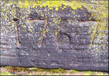
Here we see the date 1767 inscribed by the murengers into a section of the City Wall close to the Kaleyard Gate, recording the occasion when that stretch was once again repaired. The sharp-eyed will spot numerous similar inscriptions around the circuit.
By
1982,
the
inside
face
of
the
wall
immediately
north
of
the
Kaleyard
Gate,
which
had
been
leaning
for
many
years,
became
increasingly
in
danger
of
collapse
and
radical
repairs
had to be
undertaken,
involving
the
excavation
of
the
loose
core
material
and
the
tying
together
of
the
two
skins
of
stonework
with
stainless
steel
rods. As well as ensuring the stability of the ancient structure for centuries to come, it gave archaeologists a rare opportunity to investigate and record details of the foundations and internal structure of this section of the 2000 year old Roman defences. During reconstruction, all of the masonry was replaced exactly in its original position.
Romans
and
Archers
Large
sections
of
Roman
masonry
can
be
seen
at
numerous
locations
along
the
outside
of
the
present wall
here-
massive
stones
five
or
six
feet
long
and
belonging
to
the
period
of
the
reconstruction
of
the
fortress
under
the
Emperor
Trajan
around
AD105.
When
this
work
was
finished,
the
courses
we
see
were
situated
half
way
up
the
wall;
over
the
centuries
the
higher
courses
were
lost-
often
removed
for
use
elsewhere-
and
the
lower
became
buried
as
the
ground
level
rose. The
18th
century
authors
of
the Chester
Directory, Barfoot
&
Wilkes,
explained, "Before
the
present
pavements
were
laid,
all
the
ashes,
soil,
building
rubbish
and
other
adventitious
matter,
being
suffered
to
remain
in
the
streets,
might
occasion
their
present
elevation". Things
however
might
have
been
worse,
for
they
added: "The
very
great
benefit
which
the
farmers
find
in
laying
the
manure
collected
in
the
streets
upon
the
land,
has
been
the
means
of
keeping
great
towns
cleaner
than
they
were".
 The
foundations
of
barrack
blocks
and
other
Roman
structures
similarly
lie
buried
beneath
the beautiful Deanery
Field,
to
our
right, which we will discuss later. The
foundations
of
barrack
blocks
and
other
Roman
structures
similarly
lie
buried
beneath
the beautiful Deanery
Field,
to
our
right, which we will discuss later.
On
the
outer
face
of
the
great
stones
standing
out
from
the
base
of
the
East
Wall,
you
may
come
across
a
number
of
weathered
vertical
and
diagonal
grooves.
Some
of
these
are 'archer
marks',
which
were
worn
into
the
soft
stone
by
medieval
bowmen
sharpening
their
arrows
before
the
practice
sessions
which
were
compulsory
in
earlier
times
for
all
males
above
the
age
of
ten
years
old,
and
held
on
the
meadows
immediately
outside
the
Walls
at
this
point.
These
marks
are
particularly
clear
a
little
further
along,
etched
into
the
massive
Roman
stones
next
to
the
steps
opposite the
Cathedral.
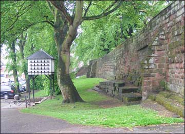
Left: the beautiful Kaleyards photographed by the author in Spring 2009. Note the stretch of original Roman masonry standing proud of the medieval wall. The white structure is a pigeon coop, erected here a few years ago in a non-too successful attempt to control the population of those birds that gather in this area in large numbers.
English-
and
Welsh-
archers
were
the
most
formidable
fighting
men
of
the
Middle
Ages,
and
the
men
of
Cheshire
were
particularly respected
for
their
skills
with
the
cloth-yard
arrow
and
the
bow
of
yew or elm
wood,
one
of
the
deadliest
weapons
of
the
day.
King Richard
II's
bodyguard
comprised "2000
Cheshire
archers" and
they
played
a
decisive
part
at
the
battles
of
Agincourt
and
Poitiers.
At
a National
Archaeology
Day event,
held
in
July
1998
at
an
exciting
long-term
excavation
of
a
long-lost
chapel
and
Cistercian
abbey
(and
now
Neolithic and Roman
features!)-
at Poulton near
Chester,
we
learned
from
members
of
the
Welsh
medieval
re-enactment
group Samhain that
the
majority
of
these
archers
actually
used
bows
made
from
shade-grown
elm
wood.
English
yew,
because
of
the
climate,
tended
to
grow
unevenly
and
was
generally
unsuitable
for
the
purpose.
That
yew
which
was
used
had
to
be
imported
from
Europe
and
was
subsequently
very
expensive. After
our
conversation,
we
also
got
the
unforgettable opportunity of
trying
out
these
formidable
weapons
for
ourselves!
"The bows used by them are not made of horn or ivory or yew, but of wild elm, unpolished, rude and uncouth, but stout; not only calculated to shoot an arrow a great distance but also to inflict very severe wounds in close fight" Giraldus Cambrensis (Gerald of Wales) c. 1207
Mwy na un bwa y'w y Nghaer "More than one yew bow in Chester" (Old Welsh proverb) |
As
we
move
on,
we
continue
to
skirt
the
beautiful Deanery
Field on
our
right.
Local guide and author Thomas
Hughes,
writing
in
1876,
remarked that "a
sight
pleasant
to
the
eye
is
that
verdant
mead,
in
olden
time
known
as
the Green
of
the
Walls". Never heard today, an older name for this area was the Laudamus Field. This would appear to have been derived from Te Deum Laudamus, an ancient Christian hymn, but the reason for the field being so called is unknown.
 Here,
on
a
summer
evening,
one
may
sometimes see
a
cricket
match
in
progress,
and
occasional
special
events
are
held
here,
such
as
the
Civil
War
Society's
superb
recreation
of
life
in
17th
century
Chester,
part
of
the
city's Divided
Loyalties festival
in
1994
and, in the summer of 2007, the occupation of the area by a horde of Vikings! Here,
on
a
summer
evening,
one
may
sometimes see
a
cricket
match
in
progress,
and
occasional
special
events
are
held
here,
such
as
the
Civil
War
Society's
superb
recreation
of
life
in
17th
century
Chester,
part
of
the
city's Divided
Loyalties festival
in
1994
and, in the summer of 2007, the occupation of the area by a horde of Vikings!
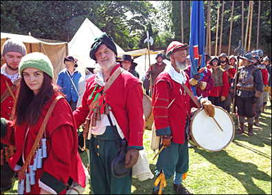
Most recently, in 2014, the Civil War Seige of Chester and the Battle of Rowton Moor were magnificently recreated by a cast of hundreds- a few of whom are portrayed here. (We hold a large number of excellent photographs of these events, should anyone be interested).
In the 1920s, the great Professor Robert Newstead undertook a major archaelogical excavation on the Deanery Field which revealed the extensive remains of the barrack blocks- home to the Roman soldiers and Centurions of the military fortress of Deva- which formerly covered this entire area. Once recorded and photographed, they were once again covered up and remain safely beneath the green field to this day.
Professor Newstead had been appointed
in 1886 and, from 1903, also of the Chester Archaeological Society, later becoming chairman. In the same year, these organisations came together to form the splendid Grosvenor Museum, a visit to which which should be considered an essential part of your time in Chester. He held the position for most of the rest of his life- even during the period 1905-24, when he was also Professor of Entomology at the Liverpool School of Tropical Medicine- a truly 'universal man'. For over half a century, he was a leading figure in the investigation of Chester's archaeology, transformed the description and display of the collections and gained widespread acceptance among developers and builders of the importance of allowing access to their site works to carry out 'rescue' excavations and recordings of finds. We should all be grateful to him.
Here is an excellent presentation of Prof Newstead's life and work, courtesy of the Grosvenor Museum and here is a photograph of his humble and neglected grave in Chester's beautiful Overleigh Cemetery.
Beyond
the
Deanery
Field
you
can
see
the
elegant
terrace
of
Georgian
houses
in Abbey Green and
the
towers
of
the
Cathedral and
Town
Hall,
as
well as- until recently at least, when they closed it down-
the
neon
sign
of
the
elegant Art Deco Odeon
Cinema in Northgate
Street-
a
view
that
to
this
day
continues
to
be truly "pleasant
to
the
eye".
Consider
the
Ravens
In 1996, for the first time in centuries, ravens returned to Chester, a pair nesting high up on the tower of Chester's Town Hall, where they successfully raised three young.
Traditionally, ravens became symbolic of Britain as a powerful country. Should they ever fly away, it was said, the monarch would fall and the nation crumble. The famous ravens at the Tower of London (and here), therefore, have their wings clipped to prevent them from flying away! By contrast, Chester's are the real, wild, thing!
When a raven shall build in a stone lion's mouth,
On a church top beside the grey forest:
Then shall a King of England be drove from his crown
And return no more.
Robert Nixon, the Cheshire Prophet |
These noble birds may be often seen flying over this stretch of wall or collecting nesting materials in the trees nearby. Witnesses have spotted them swooping upon pigeons in mid-air and returning to the nest with their prize. Although once common throughout Britain, persecution during the middle ages resulted in their dramatic decline and there are now only around 7000 breeding pairs left in the country.
 Ravens are associated with battlefields, where they fed upon the flesh of the fallen.The cawing of ravens therefore became synonymous with death and destruction and they were consequently persecuted as unwelcome visitors in towns. Ravens are associated with battlefields, where they fed upon the flesh of the fallen.The cawing of ravens therefore became synonymous with death and destruction and they were consequently persecuted as unwelcome visitors in towns.
In preparation for their return to the Town Hall in 1997, a video camera was erected on the tower connected to a monitor in the tourist information office far below. However, the Ravens chose instead to build their nest on the tower of the Cathedral- necessitating a hurried relocation of the camera- and where two chicks were successfully raised.
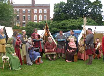
Left: a Viking parliament on the Deanery Field in the Summer of 2007
The following year, 1998, the pair, evidently trying to keep the observers on their toes, constructed nests in both locations, before eventually selecting the Town Hall tower, where a batch of six eggs was laid, five of which hatched. Tragically, in early April an engineer installing a video camera reported that the entire brood had died and the parents had disappeared. A local ornithologist, Dale Miles, commented about the death of the chicks, "It is a classic case of birds abandoning the nest because of a predator, in this case workmen installing the cameras. The council have been very amateurish. They are meant to be experts".
However, in February 1999, the pair returned to the Cathedral, successfully raising three young, and at the time of writing, February 2000, they are here again and have built their nest on a gargoyle on the Cathedral's central tower. It would appear that this man-made 'sandstone cliff' has become the noble raven's permanent home.
We invite you to go on to Part II of our exploration of the Kaleyards Gate area...
Curiosities from Chester's History
no. 5
 1170 Archbishop Thomas Becket (1118–29th December 1170) murdered in Canterbury Cathedral by four Norman knights misinterpreting the wishes of King Henry II. Nearly a century later, in 1260, the event was considered important enough to be commemorated on a ceiling boss in the new Lady Chapel of Chester Cathedral. (Surviving images of Becket's death are extremely rare as most of them were suppressed and destroyed on the orders of Henry VIII) 1170 Archbishop Thomas Becket (1118–29th December 1170) murdered in Canterbury Cathedral by four Norman knights misinterpreting the wishes of King Henry II. Nearly a century later, in 1260, the event was considered important enough to be commemorated on a ceiling boss in the new Lady Chapel of Chester Cathedral. (Surviving images of Becket's death are extremely rare as most of them were suppressed and destroyed on the orders of Henry VIII)
- 1174 The Leaning Tower of Pisa built. Robert II becomes fifth Abbot of St. Werburgh's (-1184)
- 1181 Hugh of Kevelioc died and was succeeded as sixth Earl of Chester by Ranulph de Blundeville (-1232). Robert of Chester translates De Astrolabio from Arabic into Latin.
- 1186 Robert de Hastings becomes sixth Abbot of St. Werburgh's (-1194)
- 1189 Henry II died and Richard I ('Coeur de Lion' 1157-1199) came to the throne.
- c.1190-93 Ranulph III, 6th Earl of Chester, granted and confirmed the citizens guild merchants in a charter. This was an exclusive oligarchy of merchants who rigidly controlled the town's internal trade- it was from this body that the later Craft Guilds evolved. St John's Hospital (Little St John's) founded by Earl Ranulph III; after four and a half centuries, it was destroyed by the citizens so as not to afford shelter to Parliamentary besiegers during the Civil War. On its site later rose the Blue Coat School outside the Northgate.
- 1194 Geoffrey becomes seventh Abbot of St. Werburgh's (-1208)
- 1198 Henry de Lacy, constable of Chester, collected a great body of players, fiddlers "and other loose persons" at the Midsummer Fair, and compelled Llewelyn to raise the siege of Rhuddlan Castle at which Earl Randall III was besieged, and in great straits. The following year, the Earl joined the Crusades.
- 1199 King Richard I killed at a siege in France; John (Lackland: 1166-1216), youngest son of Henry II and Eleanor of Aquitaine, succeeds him. The Choir and Tower of St. Werburgh's Abbey were completed around this time.
- 1207 (August 28th) Liverpool's first charter granted by King John- "John, by the grace of God, King of England, to all his faithful people who have desired to have burgages at the township of Liverpul, greeting. No ye that we have granted to all who have taken burgages at Liverpul that they shall have all liberties and free customs which any free borough on the sea has in our land".
- 1208 Hugh Grylle becomes 8th Abbot of St. Werburgh's (-1226)
- 1215 King John signs Magna Carta at Runnymede.
- 1216 John died, Henry III (1207-1272) succeeded.
- 1220 Earl Randle III, on his return from the Crusades, commenced the building of Beeston Castle, near Chester, funded by a tax levied upon his tenants.
- 1226 William Marmion becomes Abbot of St. Werburgh's for
just two years and is succeeded in 1228 by Walter de Pinchbeck (-1240).
- 1232 Earl Randle de Blundeville died without issue, leaving four sisters as heirs to his estate. John the Scot, Earl of Huntingdon (son of Randle's eldest daughter and David, King of Scotland) succeeded as the last independent Earl of Chester. The Black Friars (or Dominicans) were established in Chester. Their monastery and extensive grounds- now wholly vanished- was situated at the north end of Nicolas Street- their chapel being dedicated to St. Nicolas- and Blackfriars Lane.
- 1237 Earl John died without issue, poisoned by his wife Helen, a daughter of Llewellyn, Prince of Wales. Henry III annexed the Earldom to the crown, and it became a title conferred upon the Sovereign's eldest son when he is created Prince of Wales. Thus, Prince Charles is the current Earl of Chester- and the late Princess of Wales, Lady Diana was the last Countess.
The Franciscan (Grey) Friary founded north of Watergate Street.
- 1238 William the Clerk, the first Mayor of Chester, was appointed to the post in this year.
- 1240 Roger Frend becomes eleventh Abbot of St. Werburgh's (-1249)
- 1245 King Henry III ordered that all brine pits be destroyed and that the Cheshire countryside was to be impoverished in order to prevent the marauding Welsh from obtaining provisions. The decree resulted in a most terrible famine throughout the county.
- 1249 Thomas Capenhurst becomes Abbot of St. Werburgh's (-1265)
- 1254 Henry III's son, Prince Edward (later Edward I) was created the first royal Earl of Chester. The Prince developed a great love for the county and named it the 'Vale Royal of England'- founding an abbey (a vast building, now almost completely vanished)- of that name in a particularly favoured spot, a few miles from Chester.
- 1257 The Welsh under Llywelyn ap Grufydd (also called Llywelyn Ein Llyw Olaf- 'Llywelyn the last') ravaged the country "to the very gates of the city".
He was the last prince of an independent Wales before its conquest by Edward I.
- 1264 The War with the Barons. William le Zouch, Justice of Chester, ordered a deep defensive ditch to be dug outside the walls, but the Earl of Derby with a large force captured Chester for the Barons. On Christmas Eve, King Henry and Prince Edward were taken prisoner by Simon de Montfort at the Battle of Lewes, and surrendered the Earldom- the price of his ransom- up to him. However, he did not live long enough to enjoy the title as he was slain at the Battle of Evesham the following year, after which the Earldom reverted back to the Crown.
- 1265 Simon de Whitchurch
becomes thirteenth Abbot of St. Werburgh's (-1291)
- 1272 Henry died and the Prince succeeded, becoming King Edward I (1239-1307).
- 1271-95 Marco Polo journeys to China
- 1275 The Kaleyard Gate constructed (see above)
- 1276-7 Edward came twice to Chester to summon Prince Llywelyn to make peace,
but was each time refused, on the grounds that the Prince of Wales "feared
for his safety". Whereupon the King laid siege to Rhuddlan Castle, where Llywelyn
was starved into submission.
Top
of
Page | Site
Front
Door | Site
Index | Chester
Stroll
Introduction | Phoenix
Tower | Kaleyard
Gate
II
 |