Chester: a Virtual Stroll Around the Walls
Details
from
John
McGahey's
View
of
Chester
from
a
Balloon
1855:
2.
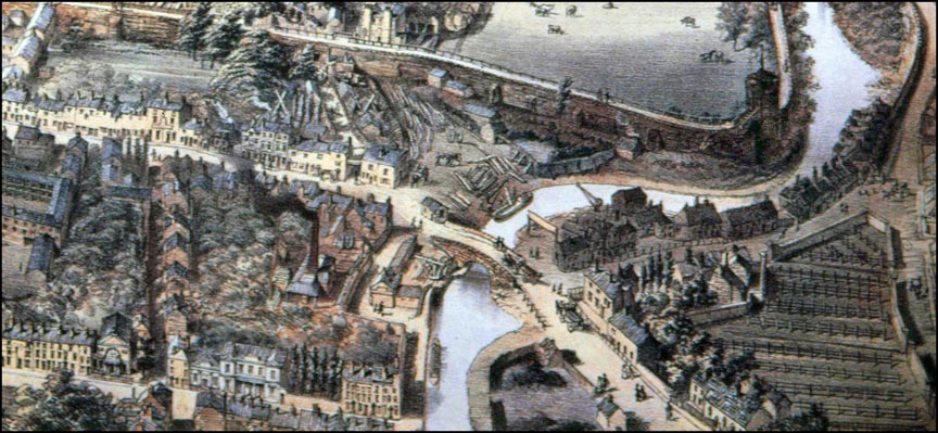
The
Kaleyards & Canal
| This
detail
from
John
McGahey's
splendid
aerial
view
of
Chester
in
1855
shows,
at
the
top,
the
Deanery
Field
and the
Phoenix Tower
on
the
north
east
corner
of
the
city
walls,
round
which
flows
the
Shropshire
Union
Canal. Local author and guide Thomas
Hughes,
writing
in
1876,
twenty
years
after
this
view
was
made,
said
of
the
Deanery
Field,
"a
sight
pleasant
to
the
eye
is
that
verdant
mead,
in
olden
time
known
as
the Green
of
the
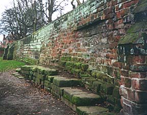
Walls". The stretch of canal next to the City walls at the top of the picture flows where once was the fosse- the defensive moat- of the Roman fortress was first dug around 80 AD. It filled up with debris over the centuries and disappeared but was re-excavated when the canal was constructed in the middle of the 18th century. Out of sight in the trees to the left of the timber yard is the smallest of the gates in Chester's City Walls, the Kaleyard Gate, built here by permission of King Edward I in 1275 to allow the monks easier access to their gardens- on condition that was built small enough to prevent armed men on horseback from riding through it and that it would be kept securely locked at night and in times of war. The tradition of locking the gate at nine o'clock each night continued right through until just a few years ago. Our photograph shows the City wall just to the left of the Kaleyard Gate. The large stones jutting out are part of the original Roman wall. They still bear deep scratches- 'archer marks'- from the days when archery was practiced (compulsory in those warlike times) on the open ground here and people used the stones to sharpen their arrows. The Kaleyards is today used as a car park. Further industrial premises, including a salt depot, were at this time located below the bridge where the Fortress & Firkin public house is today. Other enlarged sections from John McGahey's wonderful illustration:
|
 Cow
Lane
Bridge
crosses
the
canal
in
the
centre
of
the
picture,
linking
Frodsham
Street
(formerly
Cow
Lane)
with
Brook
Street
and
the
Roman
road
to
the Mersey crossing at Wilderspool, near modern Warrington.
This
bridge,
a
fine
painting
of
which
may
be
seen
Cow
Lane
Bridge
crosses
the
canal
in
the
centre
of
the
picture,
linking
Frodsham
Street
(formerly
Cow
Lane)
with
Brook
Street
and
the
Roman
road
to
the Mersey crossing at Wilderspool, near modern Warrington.
This
bridge,
a
fine
painting
of
which
may
be
seen
Site Front Door | Chester Stroll Introduction | Old Maps index | View from a Balloon | Site Index