|
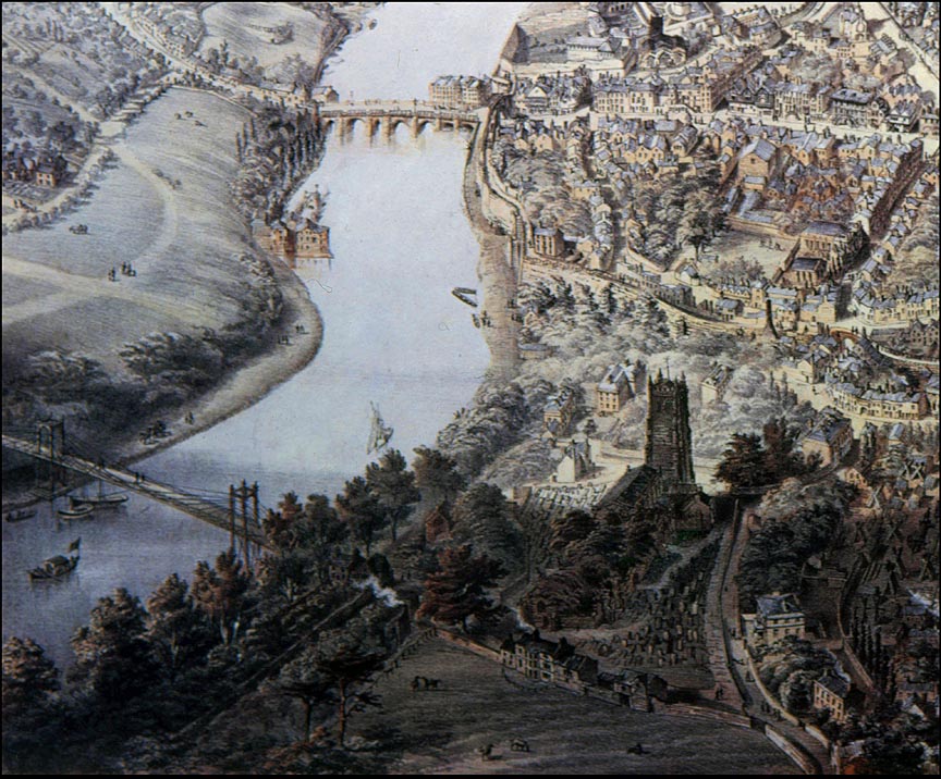
This
detail
from
John
McGahey's
wonderful
aerial
view
of
Chester
in
1855
is
the
section
of
the
original
illustration
closest
to
where
his
balloon
was
tethered
above
the
eastern
suburbs
of
the
city-
probably
near
the
junction
of
Hoole
Lane
and
Boughton (and five minutes from where these words are being written).
 We
can
see
the beautiful
River
Dee and
two
of
its
crossings:
at
the
top
is
the
Old
Dee
Bridge-
built
around
about
the
year
1387,
on
the
site
of
a
succession
of
earlier
wooden
bridges
and
a
pre-Roman
fording
place-
and
downstream
is
the
original
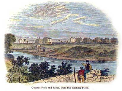
Queen's
Park
Suspension
Bridge,
which
was
built
in
1852-
just
three
years
before
this
drawing
was
made-
to
join
the
city
to
the
affluent
new suburb
of
Queen's
Park,
then
being
developed
across
the
river.
This footbridge
was
rebuilt
in
1923,
and
is
with
us
still-
indeed,
it
underwent
a
thorough
restoration
in 2002.
You
can
see
a
photograph
of
the
original
bridge
here. We
can
see
the beautiful
River
Dee and
two
of
its
crossings:
at
the
top
is
the
Old
Dee
Bridge-
built
around
about
the
year
1387,
on
the
site
of
a
succession
of
earlier
wooden
bridges
and
a
pre-Roman
fording
place-
and
downstream
is
the
original
Queen's
Park
Suspension
Bridge,
which
was
built
in
1852-
just
three
years
before
this
drawing
was
made-
to
join
the
city
to
the
affluent
new suburb
of
Queen's
Park,
then
being
developed
across
the
river.
This footbridge
was
rebuilt
in
1923,
and
is
with
us
still-
indeed,
it
underwent
a
thorough
restoration
in 2002.
You
can
see
a
photograph
of
the
original
bridge
here.
The level of the Dee must have been very high when the artist was working on this section of the picture as he has shown little trace of the great 12th century weir- normally a dominant feature of the river- that stretches diagonally between the mills on the bridge and further down on the opposite bank. Just a small section, known as the Salmon Leap, can be glimpsed above the buildings on the left. This weir remains very much with us today but both sets of mills have long since vanished.
The
open
meadow
at
the
bottom
of
the
picture
would
later
be
transformed
into Grosvenor
Park and
above
it
the
great
West
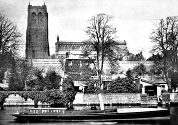
Tower
of
the
unique
and
beautiful Church
of
St. John
the
Baptist dominates
this
quarter
of
the
city,
as
it
had
done
for
hundreds
of
years.
The
Saxon
church
that
stood
here
was
founded
by
King
Aethelred
of
Mercia
in
about
the
year
689,
and
the
great
Norman
cathedral
that
replaced
it
was
never
completed
and
subsequently
suffered
from
a
series
of
disastrous
collapses
of
towers-
indeed
the
last
of
them,
the
West
Tower
shown
in
the
illustration,
was
itself
to
fall
in
1881,
twenty
six
years
after
McGahey
drew
it. We
can
see
that
the
church
at
this
time
was
surrounded
by
hundreds
of
gravestones-
all
of
which, sadly,
have
since
been
removed- and the picturesque ruins of the abandoned east end are almost hidden by a dense covering of trees and undergrowth.
At the bottom of the picture, on the edge of the meadow, may be seen the now-demolished Cholmondeley House, which was demolished when Grosvenor Park was laid out. Learn more about this and the stirring events that took place there in the St. John's Church chapters of our Chester Virtual Stroll..
 Between
St. John's
and
the
city
walls
may
be
seen
a
wooded,
elliptical
area
of
land
with
a
couple
of
large
Georgian
houses
at
each
side.
These
are St. John's
House to
the
right
and Dee
House to
the
left
and
between
them,
unbeknown
to
the
citizens
of
that
day
and
long
after,
lay
the
buried
remains
of
a
great
Roman
amphitheatre which
was
built
here
by
the
Legions
soon
after
the
establishment
of
the
fortress
of
Deva
itself,
sometime
in
the
late
70s
AD.
It
was
only
rediscovered
in
1929
and
has
almost
continually
since
been
the
subject
of
controversial
(to
put
it
mildly)
planning
decisions,
as
you
will
discover
in
some
detail here. Between
St. John's
and
the
city
walls
may
be
seen
a
wooded,
elliptical
area
of
land
with
a
couple
of
large
Georgian
houses
at
each
side.
These
are St. John's
House to
the
right
and Dee
House to
the
left
and
between
them,
unbeknown
to
the
citizens
of
that
day
and
long
after,
lay
the
buried
remains
of
a
great
Roman
amphitheatre which
was
built
here
by
the
Legions
soon
after
the
establishment
of
the
fortress
of
Deva
itself,
sometime
in
the
late
70s
AD.
It
was
only
rediscovered
in
1929
and
has
almost
continually
since
been
the
subject
of
controversial
(to
put
it
mildly)
planning
decisions,
as
you
will
discover
in
some
detail here.
At the top of the picture, across the river from the city may be seen a small open green area. Today this serves as a public park and it has for centuries been known as Edgar's Field, being the legendary site of the 10th century Royal Palace of King Edgar 'The Peacemaker'. (Read the splendid old legend of how he was rowed on the River Dee to St. John's Church by six lesser kings here).
Earlier still, there was a large quarry here which was the source of much of the stone used in the construction of the Roman fortress. This was a superior material to that used by some later generations of builders, as we saw when we visited the Cathedral and the Northgate. Excavations have shown that work in the quarry ceased around the end of the fourth century AD.
On the eastern face of a remaining sandstone outcrop, seen in the middle of the field, may be seen a remarkable survivor- a carved Roman representation of the goddess Minerva, the patron of all rivers and springs in Brittania, and also protector of of soldiers and craftsmen. Situated as she is here, facing the bridge and the ancient route to the south, she was revered as the protector of travellers. Hemingway calls her the Diva Armigera Pallas. Also known as Pallas and Athena, she was one of the most popular deities and was worshipped at the five-day March festival of Quinquatrix.
Later generations, taking her for the Virgin Mary, also worshipped and protected her, and she remains with us to this day- albeit a severely weathered shadow of her original self- and claimed to be the only representation of a Classical goddess still in its original position anywhere in Western Europe.
As
in
the Grosvenor
Bridge enlargement
from
McGahey's
aerial
view
over
the
city,
note
the
almost
total
lack
of
houses
on
the
far
bank
of
the
river
at
this
time.
Other
enlarged
sections
from
McGahey's
wonderful
illustration:
|

 We
can
see
the beautiful
 Between
St. John's
and
the
city
walls
may
be
seen
a
wooded,
elliptical
area
of
land
with
a
couple
of
large
Georgian
houses
at
each
side.
These
are