Chester: a Virtual Stroll Around the Walls
Details
from
John
McGahey's
View
of
Chester
from
a
Balloon
1855:
3.
The
River
Dee & Grosvenor
Bridge
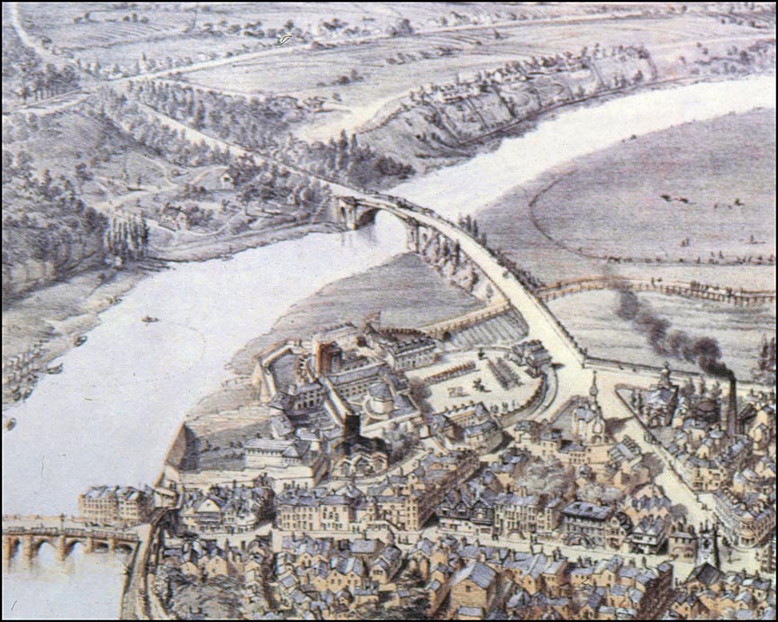
This
fascinating detail
from
John
McGahey's
aerial
view
of
Chester
in
1855 shows
the
River
Dee and
two
of
its
crossings:
at
the
bottom
left
is
the
Old
Dee
Bridge-
built
around
about
the
year
1387,
on
the
site
of
a
succession
of
earlier
wooden
bridges
and
a
pre-Roman
fording
place-
and
above
it
the
Grosvenor
Bridge which
was
completed
and
opened
to
traffic
by
the
thirteen
year-old
Princess
Victoria
(five
years
before
she
became
Queen)
in
November
1833,
just
eighteen
years
before
this
view
was
made.
The
extensive open
area
to
the
right
of
the
Grosvenor
Bridge
is
the
Roodee.
Horse
races
have
been
held
here
regularly
since
around
1533,
making
it
Britain's
(and therefore probably the world's) oldest
racecourse.
Notice
how
the
city
wall
here
is
surrounded
by
open
land
on
all
sides.
That
below
the
line
of
the
wall
formerly
belonged
to
the
Convent
of
St. Mary's
but
soon after this image was made, the large castle-like Militia Buildings were erected here to house the families of the Castle's garrison. Today, the old Militia Buildings would doubtless be in demand for conversion into 'luxury' apartments but they were sadly demolished to make way for the exceedingly ugly and inappropriately-sited County Police Headquarters, which was built between 1964 and 1967. This in turn was demolished
in 2007 and the building of a vast new complex of hotel, shops and apartments, to be called 'HQ" has recently commenced. Other enlarged sections from McGahey's wonderful illustration:
|
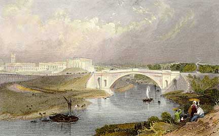 The
bridge
was
designed
by
Thomas
Harrison, the prolific architect
of
many
of
Chester's
finest
buildings,
and
proved
to
be
his
final
work-
at
the
time
of
the
commission
he
was
82
years
old.
In
fact,
he
did
not
live
to
see
its
completion-
he
resigned
aged
85
and
died
four
years
later,
the
great
task
not
yet
completed.
The
work
was
finished
by
his
able
pupil
and
assistant,
William
Cole.
The
bridge
was
designed
by
Thomas
Harrison, the prolific architect
of
many
of
Chester's
finest
buildings,
and
proved
to
be
his
final
work-
at
the
time
of
the
commission
he
was
82
years
old.
In
fact,
he
did
not
live
to
see
its
completion-
he
resigned
aged
85
and
died
four
years
later,
the
great
task
not
yet
completed.
The
work
was
finished
by
his
able
pupil
and
assistant,
William
Cole.