  fter
our
tour
of
of
the Cathedral,
we
will
now
rejoin
the
City Walls
and
wander
on. You
will
hardly
fail
to
notice
a distinctive
tall
modern structure
situated
in the corner of the churchyard here.
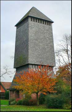
This
free-standing bell tower
or campanile is
known
as
the Addleshaw
Tower,
after
its
commissioner,
Dean
Addleshaw.
It
was
built
to accomodate the Cathedral's bells after
the
decaying bell frame in the
15th
century
central
tower
began
to
show
signs
of
stress
and
judged
no
longer
capable
of
supporting
their
great
weight. fter
our
tour
of
of
the Cathedral,
we
will
now
rejoin
the
City Walls
and
wander
on. You
will
hardly
fail
to
notice
a distinctive
tall
modern structure
situated
in the corner of the churchyard here.
This
free-standing bell tower
or campanile is
known
as
the Addleshaw
Tower,
after
its
commissioner,
Dean
Addleshaw.
It
was
built
to accomodate the Cathedral's bells after
the
decaying bell frame in the
15th
century
central
tower
began
to
show
signs
of
stress
and
judged
no
longer
capable
of
supporting
their
great
weight.
Looking rather like a windmill without sails, it was designed,
by no means
to
everyone's
taste,
by the architect to York Minster, George
Pace (1915–1975) and
completed
in
1974. It
is
the
first
free-standing
bell tower
built
for
a
cathedral
since
that of Chichester in the
15th
century.
Constructed
of
concrete
with
brick
infilling and covered with slates from the mines of Penrhyn in North Wales,
the tower
stands
86
feet
high
and
houses
thirteen
bells. The
great
Tenor
Bell
is
named
after
Christ
and
Our
Lady,
to
whom,
along
with
St. Werburgh,
the
Cathedral
is
dedicated.
It
weighs
24.75
cwt,
and
is
4ft
4ins
in
diameter.
As we learned in the last of our Cathedral chapters, the Dean & Chapter and local authority are currently planning a range of controversial 'improvements' to the environment of the churchyard, including, we hear, the addition of a cafe in the base of the Addleshaw Tower.
 The world's most famous campanile is, of course, the Leaning Tower of Pisa. To learn more about the bells of Chester and those who ring them, be sure to read Ringing in Chester by Phil Burton, here. His site offers some fascinating insights into the bellringer's art and also some nice photographs of other Chester churches. The world's most famous campanile is, of course, the Leaning Tower of Pisa. To learn more about the bells of Chester and those who ring them, be sure to read Ringing in Chester by Phil Burton, here. His site offers some fascinating insights into the bellringer's art and also some nice photographs of other Chester churches.
A
flight
of
stone
steps,
which
were
erected
in
1931
at
a
cost
of £288,
here
descend
to
an
attractive,
tree lined- but
slightly
scruffy-
area
now
used
mainly
for
car
parking,
which
has
for
centuries
gone
under
the
name
of The Kaleyards,
due
to
the
fact
that
the
vegetable
gardens
of
the
monks
of
Chester
Abbey
were
once located
here.
If
you
look
down
from
the
wall,
you
will
see
the
semi-circular
base
of
the
vanished
thirteenth-century Drum
Tower, which
had
formerly
been
used
by
the
Barber's
Company,
who
exercised
most
of
the
functions
of
physicians
and
surgeons.
Between
here
and
the Phoenix
Tower also once stood
the Sadler's
Tower until
it
was
demolished
in
1779
after
falling
into
decay.
It
had
risen
20
feet
above
the
walkway
and
contained
rooms
with
groined
roofs.
Over
its
doorway
was
a 'machicolation' for
pouring
boiling
oil,
lead
or
suchlike,
onto
the
heads
of
unwary attackers.
The
Sadler's
guild
used
the
tower
for
their
meetings,
and
paid
four
shillings
per
year
rent
for
it
in
the
sixteenth
century. We
learned
while
visiting The Kaleyards that
the
tower
was
eventually
demolished
and
the
last
traces
of
it
were
removed
when
this
section
of
wall
was
rebuilt
in
the
1820s.
The
whole
area
before
us
was
for
centuries
open
ground
and
was
utilised
by
the
Roman
garrison
as
a
parade
ground.
Below
us,
the
masive
stones
that
comprised
part
of
their
fortress
wall
are
clearly
visible,
and
may
be
closely
inspected
from
the
car
park
below.
The
road
beyond,
today's Frodsham
Street, was
once
the
commencement
of
a
Roman
road
which
ran
from just outside
the
main entrance to the fortress,
along
the
line
of
modern
Brook
Street,
through
what is now the
pleasant suburb
of
Hoole
(where
these
words
are
being
written)-
and
on
to
Frodsham
and
Warrington.
Much
of
the
route
remains
in
use
to
this
day-
although
some
sections,
as
at
the 'Newton
Hollows' in
Hoole,
are
now
little
more
than
footpaths.
If we may briefly digress from our current route, when landscaping work was undertaken at the Newton Hollows a few years ago, the council website had this to say about them,
"Newton Hollows is a rare and fascinating archaeological survival located in surburban Chester...an ancient route from Wilderspool into Chester. Originally a Roman road it was later used as a main route for people, cattle, and herds of sheep. This constant passage of trafficking over 1000 years has physically shaped The Hollows. (Note that 'Hoole' translates as 'Hollows' registered 1190AD)
It remained in use as the main route from Chester to the north until it was abandoned in the 18th century when a turnpike road was constructed on the line of Hoole Road.
In the mid 12th century it appears to have been known as 'The Valley of the Demons', perhaps with reference to the hiding place of robbers and thieves lying in wait for unsuspecting travellers. In addition, legend has it that the hollow was haunted, and travellers had to run the risk of coming across 'The Hound of Hell’ with reported sightings of a huge black, slavering dog with ‘great white teeth like knives’. It is a superb example of a medieval hollow way, though this is hard to tell due to the volume of trees and undergrowth"...
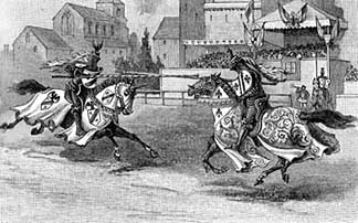 Resuming our stroll, in
the
middle
ages
the
area
before
us
was
known
as
the Jousting
Croft,
where
jousts
and
tournaments
were
held
and
games
of
all
kinds
were
played. All
round
the
perimeter
would
be
erected
the
stalls,
booths
and
amusements
of
the
fairs
and
markets
and
it
was
to
this
stretch
of
wall
that
the
townsfolk
and
visitors
flocked
to
gain
a
grandstand
view
of
the
crowds
below
at
what
must
have
been
exciting
and
colourful
occasions: Resuming our stroll, in
the
middle
ages
the
area
before
us
was
known
as
the Jousting
Croft,
where
jousts
and
tournaments
were
held
and
games
of
all
kinds
were
played. All
round
the
perimeter
would
be
erected
the
stalls,
booths
and
amusements
of
the
fairs
and
markets
and
it
was
to
this
stretch
of
wall
that
the
townsfolk
and
visitors
flocked
to
gain
a
grandstand
view
of
the
crowds
below
at
what
must
have
been
exciting
and
colourful
occasions:
"The
plain... was
a
forest
of
pavillions,
every
colour
of
the
rainbow...
Then
there
were
the
people
themselves.
All
around
and
about
the
tents
there
were
cooks
quarreling
with
dogs
who
had
eaten
the
mutton,
and
small
pages
writing
insults
on
each
other's
backs
when
they
were
not
looking,
and
elegant
minstrels
with
lutes
singing
tunes
similar
to
'Greensleeves'
with
soulful
expressions,
and
squires
with
a
world
of
innocence
in
their
eyes,
trying
to
sell
each
other
spavined
horses,
and
hurdy-gurdy
men
trying
to
earn
a
groat
by
playing
on
the
vielle,
and
gypsies
telling
your
fortune,
and
enormous
knights
with
their
heads
wrapped
in
untidy
turbans
playing
chess
and-
as
for
entertainment-
there
were
joculators,
gleemen,
tumblers,
harpers,
troubadours,
jesters,
minstrels,
tregetours,
bear-dancers,
egg-dancers,
ladder-dancers,
ballet
dancers,
montebanks,
fire-eaters
and
balancers..."
T H White: The
Once
and
Future King
 For nearly two centuries the site has been hemmed in by a conglomeration of houses, shops and other buildings, but as late as 1705, the prospect of this area from the City Walls was very different, and was then described as "a meadow, on the other side of the Gale-yards and Cow Lane, anciently, and now called the Justing Croft, wherein tilt and tourney were heretofore practised- a place very proper for these military exercises, both for the combatants, the ground not being over hard, and the spectators, who from the Walls, and from the houses adjoining on the one side, and the gently ascending grounds on the other, might with security and pleasure see the whole of the performance". For nearly two centuries the site has been hemmed in by a conglomeration of houses, shops and other buildings, but as late as 1705, the prospect of this area from the City Walls was very different, and was then described as "a meadow, on the other side of the Gale-yards and Cow Lane, anciently, and now called the Justing Croft, wherein tilt and tourney were heretofore practised- a place very proper for these military exercises, both for the combatants, the ground not being over hard, and the spectators, who from the Walls, and from the houses adjoining on the one side, and the gently ascending grounds on the other, might with security and pleasure see the whole of the performance".
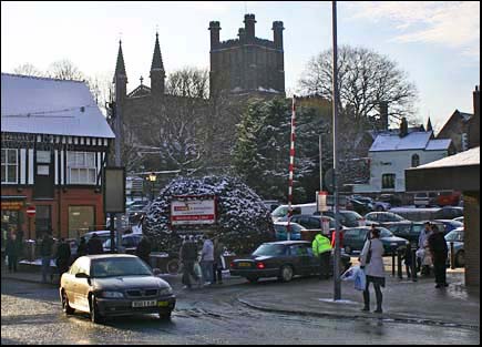
Left: a wonderful prospect of Chester Cathedral from the entrance to the Kaleyards from Frodsham Street. This view would be utterly ruined should the council's plan to build a new Market Hall here ever be realised..
Little relating to the specific contests that took place upon this ground has come to light, but an event alluded to in the 12th century by Lucian the Monk may be one. He related that, a few years before he wrote, there emerged from the City Walls a crowd of all ages, sexes and ranks, so vast in size that scarcely a wretched old woman remained at home. The occasion for this exodus was a contest between two armed horsemen in a certain level piece of ground in the presence of the king's son and a peer of the realm- a combat in which, Lucian congratulates his readers or auditors, the Englishman won. This event appears to have taken place in the year 1186 when Prince John, son of King Henry II, and Philip of Worcester, were waiting to take ship for Ireland. Lucian did not record exactly where this contest took place and the Roodee is an alternative, but unlikely site as, prior to the erection of the embankment or 'cop' in 1587, it was boggy ground, still largely covered with water.
It was probably about the close of the sixteenth century that these military exercises ceased to be performed. The Shropshire Union Canal now flows through the old Jousting Croft and part of Queen Street covers the south side of it today.
Archery practice, which was undertaken here also, was compulsory in those warlike times for all males above the age of six years. If you look carefully, you can still see the marks where they sharpened their arrows on the great Roman stones at the base of the wall in the Kaleyards. Butts for the practice of archery were first provided on the Jousting Croft in 1562, with the sanction and approbation of the Mayor and Corporation and rules laid down which included penalties for "Layers of Wadgers."
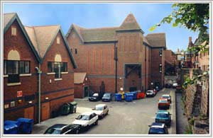 But such
romantic
scenes
of the past are
extremely
difficult
to
imagine
as
we
gaze
down
at
the
dustbins
and
back
doors
of
a
brand-new
commercial
development,
occupying
what
was
formerly
known
as Mercia
Square. But such
romantic
scenes
of the past are
extremely
difficult
to
imagine
as
we
gaze
down
at
the
dustbins
and
back
doors
of
a
brand-new
commercial
development,
occupying
what
was
formerly
known
as Mercia
Square.
This
entire
area,
hard
by
the Cathedral and
Eastgate
Clock
(see
below),
and
thus
frequented
by
more
visitors
than
probably
any
other
part
of
the
walls,
was
shamefully
allowed
to
remain
derelict
for
a
remarkable
number
of
years,
the
land
changing
hands
a
number
of
times
as
the
speculator's
game
ran
its
course.
In
time,
various
development
proposals
came
to
light,
whose
merits-
or
otherwise-
were
debated
in
the
local
press.
Here
was
a
golden
opportunity,
people
said,
to
produce
something
worthy
of
the
site's
prominent
position
in
a
historic
city
centre.
But
it
was
not
to
be:
the
third-rate
prevailed
yet
again
and
the
result
lies
before
us
now.
Reader Andy Wressel wrote
to tell us about his memories of the place as it used to be:
"I remember the bar / restaurant on the upper level of Mercia Square called Duke's Wine Bar. When you entered through the glass door you found yourself in a dark room with an L-shaped bar straight in front of you. Its restaurant was to the left of the entrance and I seem to remember wagon wheels were the theme here decorating the walls.
Next to Duke's, with an adjoining internal door, was a bar called The Pump Room. I also recall this bar had a revolving door leading from the square. The decor here was old wooden barrels used as tables.
Also on Mercia Square was the wine bar Pierre Griff's, with its 'P.Gs' motif in the window with what could only be described as a drunken cherub straddling a barrel. Inside, wine bottle candleholders covered with an unbelievable amount of melted wax were the centrepiece of each table. This wine bar must have been responsible for introducing many a young Cestrian to the pleasures of wine drinking as beers and spirits were not served here.
Mercia Square was always alive with a happy atmosphere; laughter echoed as many drinkers would spill out from the bars to enjoy the summer night air. Friends would use the square as a meeting point and inadvertently spend the rest of the evening there, lost in time".
 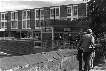 As
we
learned
when
we
passed
the Kaleyard
Gate,
over
fifty
years
ago
the Greenwood
Redevelopment
Plan advocated
demolishing
the
entire
west
side
of
Frodsham
Street
and
landscaping
the
area
before
us
to
create
that
most
unfamiliar
concept
to
Chester's
contemporary
planners-
a
new
city
park
that would perpetuate the area's ancient name-
the Hop
Pole
Paddock.
If
this
project
had
gone
ahead,
the
trees
would
now
be
mature
and
the
park
would
be
treasured
as
a
green
oasis
in
the
city
centre.
Instead
of
which,
we
have
a
collection
of
exceedingly mundane
structures
with
their
backs
turned
to
the
walls,
exhibiting
a
variety
of
refuse
bins, discarded packaging
and
shabby
advertising
banners. As
we
learned
when
we
passed
the Kaleyard
Gate,
over
fifty
years
ago
the Greenwood
Redevelopment
Plan advocated
demolishing
the
entire
west
side
of
Frodsham
Street
and
landscaping
the
area
before
us
to
create
that
most
unfamiliar
concept
to
Chester's
contemporary
planners-
a
new
city
park
that would perpetuate the area's ancient name-
the Hop
Pole
Paddock.
If
this
project
had
gone
ahead,
the
trees
would
now
be
mature
and
the
park
would
be
treasured
as
a
green
oasis
in
the
city
centre.
Instead
of
which,
we
have
a
collection
of
exceedingly mundane
structures
with
their
backs
turned
to
the
walls,
exhibiting
a
variety
of
refuse
bins, discarded packaging
and
shabby
advertising
banners.
Right: the short-lived Mercia Square precinct as seen from the City Walls. More photographs of it are here.
Mind
you,
it
could
have
been
worse- just.
At the end of the nineteenth century, it was proposed that Chester's revolutionary new electricity generating station should be built here in the old Hop Pole Paddock- much to the distress of many, including the Cathedral authorities, who in October 1893 wrote to the council that it "would be a grievous eyesore and a permanent injury to the City itself if that site is so used... Architecturally, the works would seriously effect the Cathedral which is now such an attractive feature of the City... The Chapter have always been desirous of the Hop Pole Paddock being kept as open space for the benefit of the City at large and they are quite willing to approach the Ecclesiastical Commissioners in order to see whether some substantial step can be taken to place the Paddock in trust for the enjoyment of the citizens".
The Mayor assured the Dean and Chapter that their appeal would "receive the careful consideration of the Council" but, by the following January
(1894) they had formerly decided that the thing would be built here anyway, despite objections, and also that "having settled on the site, it was not for them to deal with suggestions for keeping open space" (sounds familiar?)
In March 1894, the Cathedral authorities offered to pay the sum of £1,000 to purchase the Paddock, but their offer was initially rejected, the committee declaring that this was still the best site for the generating station. A mere month later, however, came an abrupt about-turn when the council decided to accept the Cathedral's £1,000 subject to the following conditions, 1. That it never be built upon and be forever kept open and, 2. That the Chapter relinquish the Corporation a strip of land 12 feet wide at the back of Frodsham Street if and whenever the Corporation require it for widening that street".
The electricity generating station was eventually opened in 1897 in the Water Tower Gardens at the so-called Old Port instead, where, after a long resident's battle to fight off a developer's bid to demolish it, it (or at least a token part of its' facade) remains today.
And today's Cathedral authorities, intent as they apparently are to pave over the churchyard and build on the Deanery Field, would be wise to rmember the splendid efforts of their predecessors in preserving green open space in Chester "for the enjoyment of the citizens"...
In 1921, shares were offered for a proposed Scala cinema in Frodsham Street. This was intended to be built on the site of the Hop Pole Hotel (actually 13 Foregate Street) but the plan failed to come about. Then, ten
years
after
the
Greenwood
plan-
around
1959-
it
was
proposed
to
erect
an
eight-storey
steel
and
glass office
block in
the
middle
of
Mercia
Square- another philistine plot that thankfully came to nought.
Nontheless,
if
you
would
view
the
innovative,
the
inspiring,
the
sympathetic
in
contemporary
British
architecture
and
town
planning,
it
pains
me
to
say
that
this
particular
corner
of
modern
Chester
is
decidedly
not
the
place
to
be.
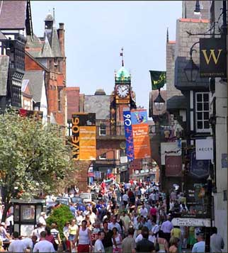 And
indeed,
in
early
2000,
we
were
concerned
to
hear
that
a
company
by
the
name
of Ethel
Austin
Shop
Properties had
sought- and obtained-
planning
permission
to
erect
a
two-storey
building
in
Frodsham
Street,
immediately
next
to
the
pedestrian
access
to
the
13th
century
Kaleyard
Gate,
a
location
described
by
the
city's
conservation
officer
as "an
exceptionally
sensitive
site".
This, happily, came to nought as the company soon after went into receivership but a more serious threat emerged at the end of 2010, a ludicrous plan to transfer Chester's Market Hall from the site it has traded on since Saxon times- the Market Square- and erect a new building to house it, of all places here on the Kaleyards! Go here for
the
details... And
indeed,
in
early
2000,
we
were
concerned
to
hear
that
a
company
by
the
name
of Ethel
Austin
Shop
Properties had
sought- and obtained-
planning
permission
to
erect
a
two-storey
building
in
Frodsham
Street,
immediately
next
to
the
pedestrian
access
to
the
13th
century
Kaleyard
Gate,
a
location
described
by
the
city's
conservation
officer
as "an
exceptionally
sensitive
site".
This, happily, came to nought as the company soon after went into receivership but a more serious threat emerged at the end of 2010, a ludicrous plan to transfer Chester's Market Hall from the site it has traded on since Saxon times- the Market Square- and erect a new building to house it, of all places here on the Kaleyards! Go here for
the
details...
The Eastgate
Clock
Moving
on,
the
walkway
becomes
briefly
hemmed
in
by
tall
buildings
on
either
side-
the
one
on
the
right
being
a
cafe,
if
you're
in
need
refreshments
or
a
bathroom-
and
through
the
narrow
space
between
we
spy
what
is
said
to
be
the
second-most
photographed
clock
in
Britain- the
first,
of
course,
being
so-called Big
Ben in
London-
the Eastgate
Clock.
In
fact,
it
is
unusual not to
see
visitors
from
somewhere
in
the
world
standing
beneath
this
clock
having
their
picture
taken.
Many
consider
it
curious
that
such
an
ancient
city
as
Chester
should
be
symbolised
by
a
monument
just
over
a
century
old!
At
the
end
of
the
19th
century
there
was
much
discussion
as
to
the
best
method
of
commemorating
Queen
Victoria's
Diamond
Jubilee-
60
years
on
the
throne-
and
a
committee
was
convened
to
settle
the
matter.
Altogether, Chester had raised £1,800 for the Jubilee Fund, one-third being for "general rejoicings", one-third for a nursing scheme but the final third was the sublect of much debate. Some
wanted
support
for
their
favourite
charities.
Extensions
to
the Bluecoat
School and Infirmary were
suggested.
The
inevitable
statue
was
proposed.
But then the
offer
of
a
commemorative
clock
was
made
by Colonel
E.
Evans-Lloyd ('citizen and freeman'),
and
this
was
accepted.
The
eminent
Chester
architect, John
Douglas was
asked
to
design
it,
and
some
local
relations
of
his,
the Swindleys of
Overleigh
Road,
who
happened
to
be
specialists
in
ornamental
ironwork,
were
commisioned
to
produce
the
mounting
for
the
clock
and
the
railings
for
the
top
of
the
gate.
The
clock
itself
was
made
by
the
old company
of J. B.
Joyce of
Whitchurch,
who
are
to
this
day
responsible
for
maintaining
it.
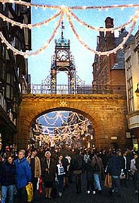 Douglas had considered the idea of erecting a clock here from at least 1881 when he had designed the adjoining Grosvenor Club. In 1884 the idea resurfaced when a masonry clock tower was suggested. It was only when Colonel Evans-Lloyd's proposals prevailed that the commission finally went ahead. Douglas had considered the idea of erecting a clock here from at least 1881 when he had designed the adjoining Grosvenor Club. In 1884 the idea resurfaced when a masonry clock tower was suggested. It was only when Colonel Evans-Lloyd's proposals prevailed that the commission finally went ahead.
The clock was run by weights instead of springs, thus enabling it to keep more accurate time. The pendulum was said to beat every one and a quarter seconds and the pendulum ball weighed one hundred-weight.
The clock's builders formerly had to make frequent visits to wind the mechanism but
since
its
conversion
to
electricity,
this
is
no
longer
necessary.
The clock was formally unveiled at a civic ceremony in 1899 by the Mayoress of Chester and Miss Sybil Clarke, Col. Evans-Lloyd's niece. During the ceremony, Colonel Evans-Lloyd said the clock was his humble contribution to his native city and he "hoped that by day and night it would prove to be a comfort and convenience, noy only to the citizens, but to the many tourists who visited the city".
For years, he said, he had wished to see a clock on the Eastgate and he had first investigated the possibility ten years previously, though the difficulty had always been to find a receptacle on which to place it. The handsome Jubilee Memorial Tower had finally solved the problem.
 J. B. Joyce, the designers of the Eastgate Clock, continue in business to this day- they even have a website- and are now part of the Smith of Derby Group. Founded in 1690, they are arguably the oldest surviving clockmaking company and their clocks grace buildings throughout the world. One of the most famous is the magnificent mechanism and dial at the Shanghai Custom House. Built in 1927, it was the largest clock ever made at the time and became affectionately known as 'Big Ching'. J. B. Joyce, the designers of the Eastgate Clock, continue in business to this day- they even have a website- and are now part of the Smith of Derby Group. Founded in 1690, they are arguably the oldest surviving clockmaking company and their clocks grace buildings throughout the world. One of the most famous is the magnificent mechanism and dial at the Shanghai Custom House. Built in 1927, it was the largest clock ever made at the time and became affectionately known as 'Big Ching'.
Other Joyce clocks are in the post offices in Sydney and Adelaide in Australia; in Nairobi, Cape Town and Port Elizabeth in Africa and in Rangoon, Calcutta, Delhi and Kabul in Asia. There are also Joyce clocks in North and South America and in Canada, and there's even one on the Falkland Islands, at Port Stanley. Much nearer and more familiar to Cestrians is the distinctive Joyce clock which stands atop a pole a mere few hundred yards for the Eastgate at the end of Foregate Street. It appears in this photograph in our 'lost pubs of Chester' gallery- the two old pubs in the picture have long since vanished, replaced by soulless office buildings, but the clock survives and continues to accurately tell us the time to this day.
Since its unveiling, our Eastgate Clock has been universally admired. Even the notoriously difficult-to-please architectural critic Nikolaus Pevsner evidently approved of the design and described it and the gateway it tops
thus: "a
rusticated
elliptical
arch,
on
it
jolly
ironwork
carrying
a
diamond
Jubilee
Clock,
by
Douglas,
and
surprisingly
playful".
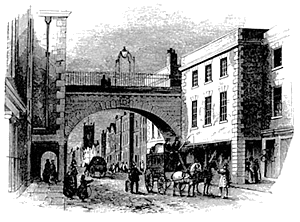
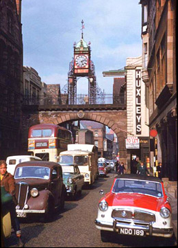
Our photograph shows heavy traffic passing beneath the Eastgate and its clock on a Summer day in 1961. The buildings look much the same today but this notorious bottleneck thankfully vanished when much of the city centre was pedestrianised.
 1997
was
the
official
centenary
of
the
Eastgate
Clock,
and
the
occasion
was
marked
by
a
variety
of
events,
including
photography
and
painting
competitions
and
a
classic
car
run
between
Big
Ben
in
London
and
the Eastgate in Chester. 1997
was
the
official
centenary
of
the
Eastgate
Clock,
and
the
occasion
was
marked
by
a
variety
of
events,
including
photography
and
painting
competitions
and
a
classic
car
run
between
Big
Ben
in
London
and
the Eastgate in Chester.
Its architect, John Douglas (1830-1911)- who was also responsible for the beautiful east side of St. Werburgh Street, the rebuilt Shoemaker's Row in Northgate Street, the impressive residences in Bath Street, the City Baths and his own home, the vast Walmoor House on Dee Banks, now lies beneath a humble tombstone in the remarkable Overleigh Cemetery, across the River Dee in Handbridge.
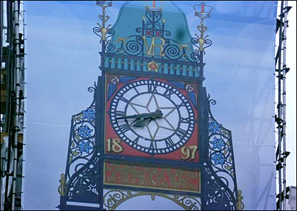
In early 2015, a £500,000 restoration commenced upon the Eastgate. The clock's ornate ironwork is being restored, as are sections of the gate's sandstone structure and heraldry. Consequently, the entire structure has been encased in scaffolding and a protective covering has been added which contains a photographic image of the bridge and clock, showing visitors Chester’s world-famous landmark hidden behind the wrap. The clock's hands protrude through the screen and continue to show the time.
This image has, since its erection, provided a great deal of local amusement due to the clock face having been printed the wrong way round!
Ascending
the
short
flight
of
steps
to
stand
directly
under
the
clock,
we
suddenly encounter
below
us
the
unexpected
bustle
of Eastgate and Foregate
Streets,
deemed
the
principal
shopping
area
of
the
city
centre.
The
attractive
cobbled
surface
here
was
laid
as
recently
as
1998
and
is
a
great
improvement
upon
the
former
tarmac
surface.
Now
go
on
to Part
II of
our
exploration
of
Eastgate
Street...
Curiosities from Chester's History no. 10
- 1485 Richard III was killed at the Battle of Bosworth Field and his body hurredly interred in the choir of a nearby monastery, that of the Greyfriars. Henry Tudor- a Welshman- ascends the throne as Henry VII (1457-1509) and starts the Tudor dynasty.
On 24th August 2012, the University of Leicester and Leicester City Council, in association with the Richard III Society, announced that they had joined forces to begin a search for the mortal remains of King Richard III. They set out to locate the remains of the church of the Grey Friars- long since demolished and now lying beneath a council car park!- and establish whether the remains of Richard III were still buried there.
On 5th September 2012 the excavators announced that they had identified the site of the Greyfriars church and human bones have since been found in the church's choir. On 12th September 2012 it was announced that a skeleton discovered during the search could be that of Richard III. Five reasons were given: the body was of an adult male; it was buried beneath the choir of the church; there was scoliosis of the spine, making one shoulder higher than the other; there was an arrowhead embedded in the spine; and there were perimortem injuries to the skull. Further laboratory tests, including DNA comparisons, are planned to verify the identification. Watch this space...
Simon Ripley becomes twenty third Abbot of St. Werburgh's (-1493)
- 1486 Henry VII further reduced the fee farm rent to £20. The citizens claimed the walls and a quarter of the city were in ruins and the city sparsely populated on account of the wealthier merchants having moved to more prosperous towns.
- 1489 Prince Arthur (1486-1502), eldest son of Henry VII stayed at Chester for a month and witnessed the Miracle Play 'The assumption of our Lady' performed at the Abbey Gate. He was described as "a great friend to the monks".
(One of the great 'what-ifs' of English history: if Arthur, "friend to the monks" had survived to become king instead of his younger brother Henry and the Dissolution of the Monasteries and creation of the Church of England had never have come about, what manner of country would we be living in now?)
Prince Arthur raised the Mayor, Richard Goodman to an Esquire. The Pentice Court was raised on the south and east sides of St. Peter's Church. The steeple was re-pointed and a goose was eaten at the top of it by the Parson and his friends, after which "they threw the bones into the four streets"
- 1493 John Puleston Esq. of Wrexham, almost killed one Patrick Kelling at the high altar of the Abbey, and so suspended the services of the church. John Birchenshawe becomes twenty fourth Abbot of St. Werburgh's (-1524)
- 1497 Katherine Knight and "the wife of John Bowes" were fined 4d for 'eaves-dropping".
- 1500 The Handbridge side of the Old Dee Bridge was rebuilt and towers added to give greater protection against the marauding Welshmen. First recorded horseraces on the Roodee. The first black-lead pencils used in England
- 1501 Arthur, eldest son of Henry VII and the first Tudor Prince of Wales, marries Catherine of Aragon (1485-1536). He died the following year, aged only sixteen years- and she went on to become the first wife of his younger brother, Henry VIII, who was six years her junior.
- 1503 All who held the rank of Mayor or Sheriff, and all innkeepers ordered to hang out lanterns , until the 8pm curfew. The order stated that all concerned "were to have hanging at their dores a lanthorne wyth a candyll byrning in it every nighte from that it be first night unto the oure of viii of the clocke, from the feast of All Saints (November 1st) until the feast of the Purification of the Blessed Virgin Mary." (February 2nd) After that, apart from the watchman's fire-brazier, absolute darkness would prevail until daybreak. The streets from the High Cross to Eastgate and to St. Michael's in Bridge Street were paved for the first time. Following the death of Prince Arthur two years earlier, Prince Henry (soon to be Henry VIII) was created Earl of Chester. Nostrodamus was born in this year. He started to write his prophesies around 1550. They were translated into English in 1672 by another French doctor, Theophilus Garencieres, whose son, Dudley, came to Chester in 1676 and served as Rector of Waverton. He was buried in the Cathedral in 1702. Dudley's wife, Elizabeth, was half-sister to another famous Cestrian, the architect and dramatist Sir John Vanbrugh.
- 1505 Chester's 'Great Charter' granted by Henry VII. This allowed that Chester be separate from the County, with the exception of the Castle and Gloverstone- a sort of no-man's land between the Castle and the City- with the title "The County of the City of Chester", and the Mayor was given the right to have his sword carried with the point erect before him, except in the King's presence. It permitted the city to appoint its own magistrates and be governed by its appointed Mayor along with 24 Aldermen, 40 Councillors, 1 Recorder, 2 Sheriffs, 2 Coroners and 2 Murangers. In this year, the old steeple of St. Werburgh's Abbey was deemed unsafe and taken down.
- 1507 The sweating sickness prevalent; 91 people died in 3 days. It was said that middle aged, red-faced people were particularly prone to the disease. During the plague, nobody was permitted to leave the city and dogs had to be kept indoors. Dirt and rubbish was not allowed to be thrown into the street, as was the usual custom. Doors of affected houses were marked with the words "Lord have mercy on us."
|

 fter
our
tour
of
of
the Cathedral,
we
will
now
rejoin
the
City Walls
and
wander
on. You
will
hardly
fail
to
notice
a distinctive
tall
modern structure
situated
in the corner of the churchyard here.
This
free-standing bell tower
or campanile is
known
as
the Addleshaw
Tower,
after
its
commissioner,
Dean
Addleshaw.
It
was
built
to accomodate the Cathedral's bells after
the
decaying bell frame in the
15th
century
central
tower
began
to
show
signs
of
stress
and
judged
no
longer
capable
of
supporting
their
great
weight.