Chester: a Virtual Stroll Around the Walls

Old Maps and Aerial Photographs of Chester


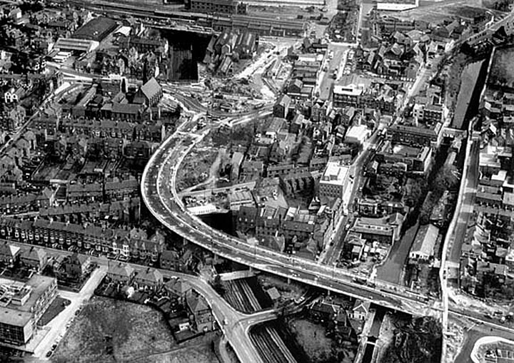
Chester from the Air: Construction of the Inner Ring Road c. 1965

Another fine aerial view showing the great changes that came to Chester during the 1960s.

St. Martin's Way, the newly-constructed elevated section of the Inner Ring Road cuts through the City Walls at St. Martin's Gate (bottom of picture), crosses the canal and railway and sweeps above the Victorian rooftops around Garden Lane before meeting the Fountains Roundabout at the foreshortened end of Northgate Street. This roundabout was described by the press at the time of its opening in 1967 as "Chester's most notable non-place": it was provided with lawns, flowerbeds and fountains, but allowed no safe pedestrian access. Pesvenor commented upon it, "The roundabout with the well-intentioned fountain destroys the street continuity, and indeed the town scale".

Beyond the roundabout, many buildings have still to be cleared to make way for the St. Oswald's Way section of the Ring Road and to its left, the road splits into two- into the present Liverpool Road and Parkgate Road- as it has done since before Roman times.

The city's North Wall, which closely follows the line of the Roman original, runs vertically up the right hand side of the picture, parallel with the Shropshire Union Canal. The British Telecom office buildings in the bottom left-hand corner were demolished in 1998 as part of British Waterway's redevelopment of Tower Wharf.

Go here to see some more photographs of the building of Chester's Inner Ring Road.

Go on to another aerial photograph of Chester...


Site Front Door | Chester Walls Stroll Introduction | Old Maps & Aerial Photographs | Site Index