|
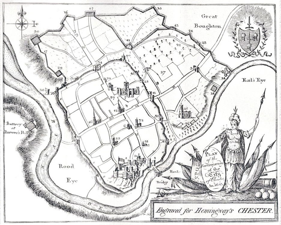
 This
map
of
Chester
actually
appeared
in
Joseph
Hemingway's
Panorama
of
the
City
of
Chester
which
was
published
in
1836-
but
reproducing
a
view
of
the
city
as
it
appeared
at
the
time
of
the
Civil
War
in
the
middle
of
the
17th
century. This
map
of
Chester
actually
appeared
in
Joseph
Hemingway's
Panorama
of
the
City
of
Chester
which
was
published
in
1836-
but
reproducing
a
view
of
the
city
as
it
appeared
at
the
time
of
the
Civil
War
in
the
middle
of
the
17th
century.
Beyond
the
familiar
line
of
the
city
walls
may
be
seen
the
extensive
secondary
defences
which
the
citizens
hurredly
constructed
of
mud,
timbers
and
whatever
other
materials
came
to
hand
in
an
attempt
to
defend
their
city
from
besieging
Parliamentary
forces.
These
defences
soon
fell,
however,
at
which
time
the
ancient
circuit
of
stone
walls
came
into
their
own
once
again,
holding
the
enemy
at
bay
throughout
a
long
and
bitter
siege-
the
last
time
they
were
to
fulfill
their
centuries-old
purpose.
On
the
far
left
of
the
picture
may
be
seen
the
battery
which
was
established
by
the
besiegers
on
high
ground
overlooking
the
River
Dee
at
a
place
called
Brewer's
Hall
Farm.
It
was
responsible
for
causing
major
destruction
in
Watergate
Street
and
the
area
later
to
be
occupied
by
the
Infirmary.
In
October
1645,
towards
the
end
of
the
siege,
the
desperate
citizens,
labouring
under
heavy
fire,
threw
up
a
great
earthwork
here
to
defend
breaches
in
the
rapidly-crumbling
city
wall.
All
available
people,
half-starved
though
they
were,
were
put
to
the
work,
including
many
women,
who
helped
to
carry
earth
in
baskets,
even
though,
as
a
contemporary
account
states, "The
women,
like
so
many
valiant
Amazons,
do
out-face
death
and
dare
danger,
though
it
lurk
in
every
basket;
seven
are
shot,
three
slaine,
yet
they
scorn
to
leave
their
matchless
undertaking,
and
thus
they
continue
for
ten
days'
space;
possessing
the
beholders
that
they
are
immortal".
The
attackers
stormed
into
the
breaches
but
the
defences
held
and
they
were
repulsed
with
heavy
losses.
The
defenders
lost
8
or
10
killed
including
their
leader,
Sir
William
Mainwaring-
to
whom
there
is
a
monument
in
the
Cathedral
The Chester historian Randle Holme III wrote of the bursting of some grenados (early mortar shells) emanating from Brewer's Hall on December 10th 1645, "Two houses in the Watergate Street skip joint from joint, and create an earthquake; the main posts jostle each other, while the frightened casements fly for fear, in a word, the whole fabric is a perfect chaos, lively set forth in the metamorphosis: the grandmother, mother and three children are struck stocke dead and buried in the ruins of their humble edifice"...
You
can
read
more
of
his
moving
account
of
the
devastation
suffered
by
Chester
during
the
Civil
War
here.
Note also how the artist has included the great sandbank in the River Dee on the far left. Once a great commercial seaport, the silting of the river effectively destroyed the trade and opened the way for the once-insignificant fishing village of Liverpool to begin its meteoric rise to become the great seaport it remains today. Calls for the dredging of the Dee were repeatedly ignored, on the understandable grounds of technical difficulty and expense. But, desperate to save the port, the river was, around 1730, eventually turned out of its ancient course into a new canalised stretch- the change can be seen on our next map- and a new harbour complex, the so-called Old Port, was created, standing well away from the City Walls on what was once the old river bed. This was successful for a while but the silting continued and all commercial shipping ceased in the early twentieth century. |