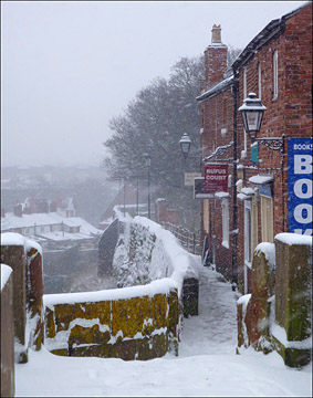
  ere
is
the
view,
as
seen
on
a
snowy
day in January 2013, as
we
leave
the Northgate and
proceed
along
the
North
Wall
with
the
Shropshire
Union
Canal
running
far
below
us.
This
section
is,
in
my
view,
the
most
spectacular
and
evocative
of
the
entire ere
is
the
view,
as
seen
on
a
snowy
day in January 2013, as
we
leave
the Northgate and
proceed
along
the
North
Wall
with
the
Shropshire
Union
Canal
running
far
below
us.
This
section
is,
in
my
view,
the
most
spectacular
and
evocative
of
the
entire
This
is
the
the
most
elevated
section
of
the
walls
and,
even
on
hot
days,
there
is
usually
a
refreshing
breeze
blowing
from
the
Welsh
hills.
The
walkway
at
this
point
is
very
narrow-
not
a
good
place
to
meet
a
large
group
of
visitors
coming
the
other
way!
From 1991-2000, your
guide's
photography
studio and gallery, The Black & White
Picture
Place,
was, for a few years, located
in the newly-developed Rufus
Court. Built by the Thompson Cox Partnership and designed by James Brotherhood, Rufus Court and is
one
of
the
finest
examples
of
that
rare
thing
in
Chester
city
centre,
a
modern
development
that
manages to blend
perfectly
with
neighbouring
old
buildings, in this case, the fine examples surrounding Abbey
Green.
Accessed
via
a
narrow
stairway
from
the
City
Walls or via Northgate Street,
you
will
find
some
excellent
cafes and
specialist
shops here and
a
great
live
music & comedy
venue, Alexander's
Bar. Read more about Rufus Court and explore the fascinating businesses to be be found there both on ChesterTourist.com and on their own website...
The
old
houses
on
the
wall
next to
the
Northgate (seen on the right of our snowy photograph),
now
coverted
into
commercial
premises with apartments above,
were erected between 1735 and 1750. The romantic novelist Beatrice Tunstall, author of The Shiny Night (1931), The Long Day Closes (1934) and The Dark Lady (1939) had her home here.
 The nearest house to the gate bears
the
distinguished
adress
of
'Number
One,
City
Walls'. The nearest house to the gate bears
the
distinguished
adress
of
'Number
One,
City
Walls'.
By
the
late
1960s,
much
of
this
area
had, in common with much of the Cathedral's estate,
become
exceedingly
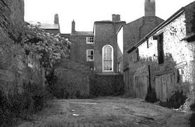
run-down. Our photographs show views of Abbey Green
from this time which will prove shocking to those who know and admire the place today.
In addition to proposing improvements to many other threatened parts of Chester, the important Insall
Report of
1968
recommended
that
this area
be
radically redeveloped
to
provide
new
shops
and
maisonettes
facing
upon
Northgate
Street
with
larger
town
houses
behind. However, the
landowners,
the
Dean
and
Chapter,
drew
up
their
own
plans
for the site which included a proposal to
erect
a five-storey
office block immediately
next
to
the
Northgate,
which
was
intended
to
fund
both
the
housing
scheme
and
the
restoration
of
adjacent
listed
buildings.
In
preparation
for
the
redevelopment,
an
extensive
archaeological
investigation
was
conducted
which
led
to
the
discovery
of
substantial
portions
of
the
Roman
rampart
and
associated
structures
and
this
in
turn
led
to
much of the
area
being
scheduled
as
an
Ancient
Monument.
Consequently,
severe
restrictions
were
wisely
placed
upon
any
new
building.
 The
Cathedral
authorities,
pleading
lack
of
money,
had
long neglected
their
historic properties
hereabouts
until, in 1978, the appoinment of
a
new
Dean
brought a fresh spirit and, assisted
by
grants,
a
radical
programme
of long-overdue repairs
was
embarked
upon.
In addition, the
new
protected
status
of
the
area
helped
to
persuade
them
to
give
up
any
idea
of
building
over
Abbey
Green
and
of
replacing
the
old
shops
in
Northgate
Street
with
their
speculative office
block,
and
they
thankfully
remain
with
us
today, home to a variety of quality businesses. The
Cathedral
authorities,
pleading
lack
of
money,
had
long neglected
their
historic properties
hereabouts
until, in 1978, the appoinment of
a
new
Dean
brought a fresh spirit and, assisted
by
grants,
a
radical
programme
of long-overdue repairs
was
embarked
upon.
In addition, the
new
protected
status
of
the
area
helped
to
persuade
them
to
give
up
any
idea
of
building
over
Abbey
Green
and
of
replacing
the
old
shops
in
Northgate
Street
with
their
speculative office
block,
and
they
thankfully
remain
with
us
today, home to a variety of quality businesses.
The
City
Council
around
this
time
expressed
an
interest
in
putting
the
excavated
Roman
buildings
on
permanent
public
display
and
of
taking
over
no.1
Abbey
Green
(the
furthermost
building
in
the
top
photograph)
to
serve
as
an
interpretive
centre.
Sadly
this
failed
to
come
about;
the
remains
were
carefully
reburied
and
the
fine
house
continued
to
decay
until
the
early
1990s,
when
it
was
superbly
restored
and
converted
into
a
restaurant
within
the
Rufus
Court
development.
As recently as the the Summer of 2011, as part of the fierce debate surrounding the controversial (and, thankfully, unsuccessful) Cathedral Improvement Proposals, concern of neglect by the Dean & Chapter of their historic properties in the area was once again being expressed in the correspondence pages of the local press- smashed windows and peeling paint on the listed Georgian houses in Abbey Green, damaged cobbled surfaces and empty properties in the beautiful Abbey Square- which we will visit later in our stroll- rubbish accumulating on the Deanery Field, the adjoining and once-charming Deanery Cottage empty and decaying, vehicle damage and nelect of the Abbey Gateway and the area around the Little Abbey Gateway...
You
may
be
interested
in
seeing this remarkable
aerial
view-
a
detail
from
John
McGahey's
famous View
of
Chester
from
a
Balloon- showing
how
the
area
appeared
in
1855.
Roman
Wall
 As
you
look
out
from
the
parapet,
you
will
often
observe
people
standing
on
the
bridge
immediately
outside
the Northgate,
peering
through
the
railings
at
the
spectacular
masonry
of
the
North
Wall
and
the
Shropshire Union Canal
running
far
below. You
should
take
the
time
to
join
them
before
we
move
on-
especially
in
springtime,
when
the
entire
length
of
the
wall
base
is
covered
with
a
mass
of
daffodils.
A
stroll
along
the
newly-resurfaced
canal
towpath
below
is
also
highly
recommended
at
some
time
during
your
visit-
access
is
through
an
archway
in
the
wall
close
to Morgan's
Mount or
via
the
wooden
steps
near
the Kaleyard
Gate- as the view upwards of the epic masonry of the North Wall, and the sandstone palateau upon which it was built- is unrivalled anywhere. As
you
look
out
from
the
parapet,
you
will
often
observe
people
standing
on
the
bridge
immediately
outside
the Northgate,
peering
through
the
railings
at
the
spectacular
masonry
of
the
North
Wall
and
the
Shropshire Union Canal
running
far
below. You
should
take
the
time
to
join
them
before
we
move
on-
especially
in
springtime,
when
the
entire
length
of
the
wall
base
is
covered
with
a
mass
of
daffodils.
A
stroll
along
the
newly-resurfaced
canal
towpath
below
is
also
highly
recommended
at
some
time
during
your
visit-
access
is
through
an
archway
in
the
wall
close
to Morgan's
Mount or
via
the
wooden
steps
near
the Kaleyard
Gate- as the view upwards of the epic masonry of the North Wall, and the sandstone palateau upon which it was built- is unrivalled anywhere.
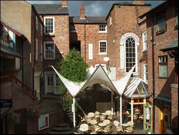
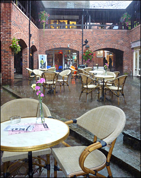
Two views of Rufus Court today: a civilized oasis in the heart of a historic city- no matter what the weather!
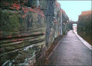
The
masonry
immediately
below
the
parapet-
best
viewed
from
the
aforementioned
bridge
or, as mentioned,
from
the
towpath-
deserves
your
close
attention
as
it
is
the
finest
surviving
stretch
of actual Roman
stonework
in
the
entire
circuit;
laid
in
place,
amazingly,
almost two thousand years
ago- c. 90 to 120 AD-
and
bearing
witness
to
the
skill
of
the
Legionary
engineers
in
utilising
only
the
best
available
stone
in
the
construction
of
their
defences.
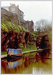
 Our photograph below shows the view from the bridge outside the Northgate. On the left runs the Shropshire Union Canal and its towpath. Above it rises the escarpment of Triassic sandstone upon which the old fortress was built. The City Wall is built on top of this- you can clearly see the original Roman portion standing proud of the later, medieval masonry. Our photograph below shows the view from the bridge outside the Northgate. On the left runs the Shropshire Union Canal and its towpath. Above it rises the escarpment of Triassic sandstone upon which the old fortress was built. The City Wall is built on top of this- you can clearly see the original Roman portion standing proud of the later, medieval masonry.
This marvellous vista had been considerably curtailed due to the unchecked proliferation of sycamore trees growing atop the ridge and along the base of the wall. These had attained a considerable height, thoroughly obscuring the view- and doubtlessly causing all manner of damage to the ancient masonry. Eventually, in 2010, a radical programme of improvements was initiated which cleared the growth and made good damage to the wall.
Much
of
the
material
for
the
construction of the fortress
was
labouriously
transported
from
a
large
quarry
on
the
far
side
of
the
River
Dee,
today
a
park
known
as Edgar's
Field which
supplied
fine
building
stone
throughout
the
Roman
occupation
and
after.
Additional
supplies
of
building
stone
also
came
from
sources
nearer
to
hand,
such
as
that
excavated
during
the
construction
of
the
deep
defensive
ditch
or fosse which
we
see
before
us
carrying
the
canal and the area just across the canal. The large quarry here recently came to light again- after being filled in for centuries- when the bus station which occupied the site was demolished. We will learn more of this shortly...
In
1711,
there
was
a
mention
of
a "quarry
near
the Phoenix
Tower" and
the
site
of
another
small
local
quarry,
known
as
the Abbey
Quarry still
exists
just
behind
the
buildings
on
the
far
side
of
Abbey
Green
and
is
today
utilised
for
car
parking.
Excavated
at
the
base
of
the
natural
sandstone
escarpment,
the fosse,
during
the
centuries
of
Roman
occupation
would
have
been
carefully
kept
clear
of
any
debris
and
vegetation
by
which
a
potential
enemy
might
gain
cover
or
even
a
handhold
to
assist
in
scaling
the
wall. Maintainance
ceased
with
the
withdrawal
of
the
Legions,
and
subsequent
natural
erosion,
as
well
as,
in
those
less-than-scrupulous
times,
domestic
waste
of
all
kinds
being
disposed
of
by
simply
being
thrown
over
the
wall,
over
the
course
of
centuries
resulted
in
the
fosse
filling
up
and
virtually
disapearing. By
the
13th
century,
the
section
below
us
was
occupied
by
a
low-lying,
unsavoury
sounding
thoroughfare
by
the
name
of Boggelone (Bog
Lane)
which
ran
parallel
with
the
wall
immediately
outside
the
Northgate.
 At
the
commencement
of
the Baron's
War in
1264,
between
Henry
III
and
his
barons,
led
by
Simon
de
Montfort,
steps
were
taken
to
put
the
city
into
a
state
of
defence,
much
to
the
distress
of
the
monks
of Chester
Abbey-
partly
due
to
the
fact
that
they
sympathised
(but
not
too
openly)
with
De
Montford,
but
also
because
they
owned
houses
in
Bog
Lane,
which
were
demolished
when
the
old
Roman
defences
were
re-excavated.
The
restored
defensive
ditch
also
prevented
access
to
the
monk's
vegetable
gardens
outside
the
East
Wall,
the Kaleyards,
and
later "It
was
ordered
that
a
drawbridge
should
be
put
across
the
fosse
at
the
Kaleyard
Gate". At
the
commencement
of
the Baron's
War in
1264,
between
Henry
III
and
his
barons,
led
by
Simon
de
Montfort,
steps
were
taken
to
put
the
city
into
a
state
of
defence,
much
to
the
distress
of
the
monks
of Chester
Abbey-
partly
due
to
the
fact
that
they
sympathised
(but
not
too
openly)
with
De
Montford,
but
also
because
they
owned
houses
in
Bog
Lane,
which
were
demolished
when
the
old
Roman
defences
were
re-excavated.
The
restored
defensive
ditch
also
prevented
access
to
the
monk's
vegetable
gardens
outside
the
East
Wall,
the Kaleyards,
and
later "It
was
ordered
that
a
drawbridge
should
be
put
across
the
fosse
at
the
Kaleyard
Gate".
These
precautions
did
not
prevent
the
city
being
briefly
captured
soon
after
by
the
Earl
of
Derby,
but
the
monks
eventually
got
their
revenge,as
he
was
afterwards, "Imprisoned
for
a
long
time
in
the
Tower
of
London,
on
account
of
his
many
excesses
of
authority,
and
especially
on
account
of
the
injuries
done
by
him
to
ecclesiastics".
After the restoration of peace, the old fosse presumably resumed its ancient role as town dump and, though it is shown on Braun's map of 1573, it evidently filled up again and by the start of the 17th century part of it was being used as a pinfold- a place to confine straying animals. Lavaux's map of 1745 shows no trace of it whatsoever. Today, we so take for granted the presence of the canal that, studying our enlarged details of Lavaux's map, the townscape appears distinctly odd minus its deep cutting running hard under our City Walls.
Actually, this was very nearly the situation that could have prevailed today, for, in the early 1770s, when the canal's route was being planned, the original intention was to take it along the far (north) side of Gorse Stacks, George Street and Canal Street- hence the latter's name! Excavation along this route seems to have actually commenced- the February 1879 edition of the Cheshire Sheaf contained this contribution from one Mr Charles Candlin of Mold, "It has struck me, as to the original line proposed for the Canal near the Northgate, that a hollow, lying about 100 yards behind the houses on the north side of George-street, and parallel with it, is a remain of the first cutting. To confirm this, on going down the entry at No. 17, you will see the rock cut three or four yards deep; and behind No. 28 a strong wall in the same line, and about the same height above the hollow, which is now partly filled with cottages at right angles with the street. No doubt when the tumble-down houses, recently bought by the Town Council, are removed from the corner of George-street and Victoria-road, some further trace may be found at the north end of the houses, though these latter were no doubt standing when the Canal itself was built".
 However, just before the work was actually commenced, the canal company's directors, for some reason, vacillated in their judgment, and asked the contractor to adopt the southern limit of their deviating powers, and so carry the canal close under and parallel with the City Walls. The original line involved continuous and heavy excavation through the sandstone rock; and the contractor, feeling that the question of a few yards either way could make no very great difference to him, accepted the proposition of the directors. Judge the surprise of all concerned, when it was found that the new line actually took the course of the ancient Roman fosse, excavated some 1500 years before, and for long ages filled up and made solid ground! The result was that the contractor made a considerable fortune by his undertaking. However, just before the work was actually commenced, the canal company's directors, for some reason, vacillated in their judgment, and asked the contractor to adopt the southern limit of their deviating powers, and so carry the canal close under and parallel with the City Walls. The original line involved continuous and heavy excavation through the sandstone rock; and the contractor, feeling that the question of a few yards either way could make no very great difference to him, accepted the proposition of the directors. Judge the surprise of all concerned, when it was found that the new line actually took the course of the ancient Roman fosse, excavated some 1500 years before, and for long ages filled up and made solid ground! The result was that the contractor made a considerable fortune by his undertaking.
It is unclear whether the new course had been adopted when this entry appeared in the City accounts: "1772, May 18. To a gratuity by Mr. Mayor's order on his cutting the first sod of ye Canal £5 5s 0d". But, by a year later, it is clear that the changes had been made, for we read, "1773, May 10. Paid Mr. Golborne for his Trouble in Surveying, Levelling, and reporting ye Course of ye Canal and ye guarding of ye Walls and City Buildings £3 3s 0d". The Corporation would naturally be anxious to ascertain whether the projected new course would in any way jeopardise the City Walls and adjacent buildings. That Mr. Golborne's report was not unfavourable to the scheme may be inferred, as we hear of no opposition to it.
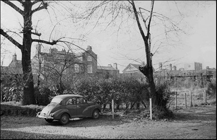
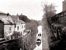
 A month afterwards is the following entry: "1773. June 10. Paid Mr. Read for measuring part of ye Ho. of Correction Garden taken by ye Proprietors of ye Canal £0 7s 6d". It is but reasonable to suppose that if the altered course had been the one commenced by the Mayor in 1772, the payments to Messrs. Golborne and Read would have appeared at a much earlier date, as their work must have taken place before May of that year. The House of Correction stood on the plot of ground between George Street and the North Wall and survived into the age of photography, for we see on the left of this old picture. The garden belonging to it once extended up to the Wall itself, and would not have been interfered with had the Canal been constructed along the line first determined upon. A month afterwards is the following entry: "1773. June 10. Paid Mr. Read for measuring part of ye Ho. of Correction Garden taken by ye Proprietors of ye Canal £0 7s 6d". It is but reasonable to suppose that if the altered course had been the one commenced by the Mayor in 1772, the payments to Messrs. Golborne and Read would have appeared at a much earlier date, as their work must have taken place before May of that year. The House of Correction stood on the plot of ground between George Street and the North Wall and survived into the age of photography, for we see on the left of this old picture. The garden belonging to it once extended up to the Wall itself, and would not have been interfered with had the Canal been constructed along the line first determined upon.
Civil War Defences
There
was
even
less
evidence
of
a
ditch
here
later
in
the
17th
century,
during
the
Civil
War
Siege
of
Chester,
when
there
was
a
danger
of
this
stretch
of
wall
being
breached
by
cannon
and
mortar
fire,
allowing
access
to
the
Parliamentary
attackers.
Great
piles
of
earth
were
raised
against
the
insides
of
the
wall
to
prevent
this-
although
the
defenders
may
only
have
had
to
reinforce
the
existing
embankments
surviving
from
the
remains
of
the
Roman
turf
ramparts
which
preceded
the
erection
of
permanent
stone
walls.
These
old
earthworks,
now
planted
with
trees,
remain
clearly
visible
around
the
edge
of
the
Deanery
Field
to
this
day.
You
can
gain
access
to
this
field,
a
very
pleasant
spot indeed,
by
going
down
the
steps
into
Rufus
Court
and
turning
left
along
Abbey
Green.
We
are
grateful
to
correspondant
Richard
Edkins
for
the
following: "During
the
1970s
I
served
as
voluntary
assistant
to
the
Museum
photographer,
Tom
Ward,
during
the
Abbey
Green
section
of
the
North
Wall
excavations.
If
you
examine
the
site
report,
you
will
find
that
the
Civil
War
entrenchments
were
dug
through
the
Roman
turf
and
timber
backing
mound
of
the
Wall.
The
mural
buildings
built
into
the
mound
included
well-preserved
Roman
baking
ovens
and
storehouses,
partly
destroyed
by
Civil
War
entrenchments
and
by
the
1940s
excavations
of
Professor
Robert
Newstead. The
grim
reality
of
warfare
was
shown
by
large
numbers
of
flattened
and
spent
musket
balls
embedded
in
the
back
of
the
Civil
War
trench.
If
my
memory
serves
me
correctly,
the
attack
was
at
dawn
on
7th
July
1644,
and
was
successfully
beaten
off".
In
1995,
shards
of
pottery
found
here
and
assumed
to
be
of
Iron
Age
origin,
were
identified
by
the
British
Museum
as
actually
being Neolithic (c.
3500-1700BC)
making
them
the
first
examples
of
pottery
of
this
period
known
from
Cheshire,
and
a
graphic
illustration
of
the
great
antiquity
of
human
occupation
of
this
site.
More
prehistoric
artefacts
came
to
light
during
at
Chester's
Roman amphitheatre in
the
Summer
of
2000,
when,
during
an
excavation
led
by
archaeologist
Keith
Matthews,
a
volunteer
discovered
a
Neolithic
flint
blade
dating
from
around
4000 BC,
and
later
an
arrow
or
spear
point
from
around
4500 BC
came
to
light-
a
period
before
widespread
farming
when
hunters
roamed
the
land
in
search
of
deer
and
wild
boar.
Roman
Memorials
 During
repairs
to
the
North
Wall
near
to Morgan's
Mount in
1883,
the
workmen
were
surprised
to
discover
large
quantities
of
sculpted
and
inscribed
stones
packed
into
the
wall's
interior.
When,
four
years
later,
in
1887,
further
repairs
were
carried
out
in
the
vicinity
of
the
Deanery
Field,
a
great
many
similar
finds
were
made.
It
was
soon realised
that these
were
of Roman origin and
a
systematic
investigation
was
commenced. By
the
end
of
1892,
over
two
hundred
complete
or
fragmentary
pieces
had
been
recovered.
Most
of
these
were
tombstones
which
seem
to
have
been
taken
from
a
nearby
cemetery
situated
outside
the
fortress.
Burials
were
not
allowed
within
Roman
forts and
cemeteries
were
commonly
located
in
prominent
positions
on
either
side
of
the
approach
roads. During
repairs
to
the
North
Wall
near
to Morgan's
Mount in
1883,
the
workmen
were
surprised
to
discover
large
quantities
of
sculpted
and
inscribed
stones
packed
into
the
wall's
interior.
When,
four
years
later,
in
1887,
further
repairs
were
carried
out
in
the
vicinity
of
the
Deanery
Field,
a
great
many
similar
finds
were
made.
It
was
soon realised
that these
were
of Roman origin and
a
systematic
investigation
was
commenced. By
the
end
of
1892,
over
two
hundred
complete
or
fragmentary
pieces
had
been
recovered.
Most
of
these
were
tombstones
which
seem
to
have
been
taken
from
a
nearby
cemetery
situated
outside
the
fortress.
Burials
were
not
allowed
within
Roman
forts and
cemeteries
were
commonly
located
in
prominent
positions
on
either
side
of
the
approach
roads.
Over the heather the wet wind blows,
I've lice in my tunic and a cold in my nose.
The rain comes pattering out of the sky,
I'm a wall soldier, I don't know why.
The mist creeps over the hard grey stone,
My girl's in Tungria; I sleep alone.
Aulus goes hanging around her place,
I don't like his manners, I don't like his face.
Piso's a Christian, he worships a fish;
There'd be no kissing if he had his wish.
She gave me a ring but I diced it away;
I want my girl and I want my pay.
When I'm a veteran with only one eye
I shall do nothing but look at the sky.
W H Auden: Roman Wall Blues |
Generations
of
soldiers
had
been
buried
there
and
the
tombstones
recorded
the
names,
ranks
and
sometimes
portraits
of
these
deceased
warriors
and
members
of
their
families,
and
commonly
included
a
carving
of
a
wild
boar,
the
symbol
of
the
XXth
Legion. They
range
in
date
from
around
70 AD
to
the
early
third
century
and
represent
every
type
of
citizen:
soldiers
and
civilians,
men
and
women,
young
and
old-
from
France,
Spain,
Italy,
Slovenia
and
Turkey.
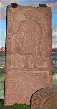
Illustrated
here is
a
typical
memorial
stone
from
the
North
Wall.
It
measures
50
inches
high
by
25
inches
wide
and
contains
a
full-length
portrait
of
the
deceased,
under
which
is
inscribed: "To
the
memory
of
Caecilius
Avitus
of
Emerita
Augusta, Optio of
the
Twentieth
Legion,
who
served
for
fifteen
years
and
lived
thirty
four
years.
His
heir
had
this
erected."
The nature of the emergency that led to
these
memorial stones
being
hauled from their cemetery and built into the fabric
of
the
wall remains entirely mysterious, and probably always will.
Despite
the
undoubted respect
the
Romans
had
for
their
dead,
it
seems
they
were
no
sentimentalists-
they
had
lived
and
died
for
the
Empire
and
now
their
tombstones
would
contribute
further
to
its
defence.
Whatever
the
cause,
for
us
at
least
it
was
a
fortunate
event,
for
these antique memorials
that would normally have been long lost and forgotten have
remained
fresh
and
unweathered
and
many of them are
now
proudly
displayed
in
their
own
gallery
at
the spendid Grosvenor
Museum-
one
of
the
most
important
collections
of
Roman
inscriptions
and
sculpture
anywhere in
Europe.
We
highly
recommend
you
take
the
time
to
visit
them,
together
with
the
superb
mural
by
Chester-based
artist
Gregory
Macmillan
which
vividly recreates in exquisite detail the fortress of Deva Victrix as it may have appeared when these stones were still standing in their lost cemetery.
One of the stones in the gallery, that of Callimorphus and his young son Serapion, was discovered in a former Roman cemetery on the other side of the city, close to what is now Britain's oldest racecourse, the curiously-named Roodee. Learn more here.
Maintaining the Walls (or otherwise?)
This
photograph
shows
the
North
Wall
as viewed from
the
far
side
of
the
canal.
Clearly
visible
is
the
face
of
the
Triassic
sandstone
outcrop
upon
which
Chester
sits-
liberally
decorated
by
a
mass
of
spring
daffodils
and
topped
by
the
splendid
Roman
masonry
and
Thomas
Harrison's
Classical Northgate. Compare
this
with Moses
Griffith's view
in
the
previous
chapter.
 As previously observed, this view has altered somewhat in the twenty years since the photograph was taken due to the large number of saplings that have been allowed to thrive unchecked on top of the escarpment and along the base of the wall. As previously observed, this view has altered somewhat in the twenty years since the photograph was taken due to the large number of saplings that have been allowed to thrive unchecked on top of the escarpment and along the base of the wall.
From
1307,
Chester
collected
revenue
for
the
maintainance
of
its
walls
and
other
defences
by
exacting
a
toll
known
as murage upon
all
goods
entering
the
town
that
could
not
be
carried
by
hand.
For
this
purpose,
tollhouses
were
erected
outside
the
gates
and
the
small
building
you
can
see
on
the
right
of
the
Northgate
in
this
picture
is
the
city's
only
surviving
example,
though
much
altered
and
long
since
converted
to
a
private
residence. If
someone
refused
to
pay
the
toll,
the
gatekeeper
had
the
right
to
take
the
bridle
off
his
horse.
The
last
time
this
happened,
the
horse
bolted
and
ran
amok-
an
incident
that, it is said,
contributed
to
the
eventual
ending
of
the
practice.
Murage
was
also
charged
on
goods
carried by ships entering
the Port
of
Chester.
At
the
end
of
the
18th
century,
a
duty
of
two pence
was
charged
on
every
100
yards
of
Irish
linen
imported.
In
1786,
about
five
and
a
half
million
yards
entered
the
port,
excluding
that
destined
for Liverpool,
which
also
paid
duty
to
Chester.
These
tolls
were
eventually
abolished
in
1835.
In October 2006, something of an almighty row broke out regarding the state of our precious walls as more and more people started to notice a decline in their condition, including loose stonework and hand rails and weeds- even small trees (see above)- growing from them. It is certainly the case that the nearby Morgan's Mount has, sadly, long been closed off from visitors for safety reasons. (the inexplicable and unforgivable closure of the Phoenix, Water and Bonewaldesthorne's Towers remains another matter, however).
 It was alleged that vital maintainance work had not been carried out for some considerable time and the funds set aside for the purpose had instead been spent on other projects including planning for the restoration of Chester Railway Station and its surroundings. Much hand-wringing ensued- not to mention a great deal of accusation and name-calling between political parties- and a council working party reported that, much as they wished it otherwise, there simply wasn't enough money avilable to do the job properly and desperate appeals were made to central government to make up the shortfall. It was alleged that vital maintainance work had not been carried out for some considerable time and the funds set aside for the purpose had instead been spent on other projects including planning for the restoration of Chester Railway Station and its surroundings. Much hand-wringing ensued- not to mention a great deal of accusation and name-calling between political parties- and a council working party reported that, much as they wished it otherwise, there simply wasn't enough money avilable to do the job properly and desperate appeals were made to central government to make up the shortfall.
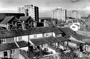
Right: a rich mixture of architectural styles- 18th century cottages, 19th century school, chapel, pub (the excellent, but recently-closed, Ship Victory- the only pub in Britain to bear that distinguished name), 1960s apartment blocks and car parks- is visible as we reach the northeast corner of the City Walls.
For many centuries past, when keeping the walls in good order was seen as vital to the safety and well-being of the city, laws to ensure that all who did business here contributed to the cost of their upkeep were strictly enforced. Today, it remains equally vital- albeit for economic and cultural, rather than defensive reasons- that Chester's City Walls and Rows are maintained to the highest possible standards.
Is it not reasonable then, and especially in the face of likely government indifference, that the ancient practice of murage should be revived and that the numerous big business interests currently developing hotels, nightclubs, housing and retail complexes in and around our city, confident as they doubtless are of extracting large profits, should not, perhaps as a condition of their planning permission, to be compelled to do their bit and give a little back?
Fear mongering became reality a few months later, however, when the stretch of City Wall adjoing the Grosvenor Precinct was actually closed to the public. It seemed that a section of adjoining 18th century brick wall started to signs of collapse. It once formed the rear wall of an 18th stable block which was unaccountably allowed to remain in place when this was demolished to make way for the precinct. The walkway remained closed to the public for several months until, with reassurances that all was well, reopening. But much more serious trouble was to follow a few months later, in April 2008. Work had recently started on removing the troublesome brick wall when a great stretch of the ancient City Wall itself collapsed onto the recently-erected scaffolding. The entire stretch has now been sealed off and it will now, sadly, remain closed for the forseeable future. It seems that the 'scaremongers' were right all along. Go here for the latest...
Extensive
maintainance work was
carried
out
on
the
outer face of the North Wall
between
the Northgate and
the Phoenix
Tower during
the
severe
winter
of
1981-82.
This
necessitated
the
erection
of
scaffolding
from
the
canal
towpath
some
fifty
feet
below
and
the
masons
working
in
this
exposed
position
compared
conditions
to
the "north
face
of
the
Eiger"...
 In November 2009, a structural problem was detected- a wall lying up against the City Wall in Rufus Court (see above) has become detached and a programme of repairs is to be embarked upon during December and January 2010. This will necessitate the temporary closure of this section of the wall walkway and also of the canal towpath below. As part of the work, we believe that the damaging trees on the face of the North Wall are to be removed. By the Spring of 2010 all of the above work was completed. The damaging saplings are gone and their stumps have been treated to, hopefully, prevent their return and the scene looks very much more like it appeared in the colour photograph higher up this page. In November 2009, a structural problem was detected- a wall lying up against the City Wall in Rufus Court (see above) has become detached and a programme of repairs is to be embarked upon during December and January 2010. This will necessitate the temporary closure of this section of the wall walkway and also of the canal towpath below. As part of the work, we believe that the damaging trees on the face of the North Wall are to be removed. By the Spring of 2010 all of the above work was completed. The damaging saplings are gone and their stumps have been treated to, hopefully, prevent their return and the scene looks very much more like it appeared in the colour photograph higher up this page.
 At the time of this most recent update, late Summer 2014, scaffolding continues to prop up the steps to the Northgate (closing Water Tower Street in the process) and the City Wall behind Rufus Court. Down at the River Dee, the Recorder's Steps are similarly propped up and the nearby wall adjoining the access to the Roman Garden has been closed to the public for 'safety reasons'. The Watergate, too, continues to be encased in scaffolding and plywood. We're told that funding for putting this right will not become available until at least 2017! Things appear to be getting worse rather than better.. At the time of this most recent update, late Summer 2014, scaffolding continues to prop up the steps to the Northgate (closing Water Tower Street in the process) and the City Wall behind Rufus Court. Down at the River Dee, the Recorder's Steps are similarly propped up and the nearby wall adjoining the access to the Roman Garden has been closed to the public for 'safety reasons'. The Watergate, too, continues to be encased in scaffolding and plywood. We're told that funding for putting this right will not become available until at least 2017! Things appear to be getting worse rather than better..
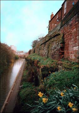
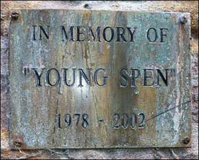
Looking down from the North Wall for the first time, visitors are often unnerved by the terrifying drop to the canal below and the lack of protection offered by the low stone parapet. Unsurprisingly, a number of accidents have occured over the years at this spot when people have tragically fallen to their deaths. Floral tributes may be seen on the towpath below and the sharp eyed may spot this small brass plaque (right) attached to the face of the cutting.
The
Coming
of
the
Canal
In
the
middle
of
the
18th
century,
the
canal
builders- the 'navigators'-
came
to
Chester
and
it
was
decided
that
the
course
of
their
new
cut
should
run
outside,
and
parallel
with
the
line
of
the
North
Wall. It was originally intended to construct a tunnel here but when the
contractors,
expecting
to
have
to
cut
through
solid
rock,
were
surprised
to
encounter
the
long-forgotten
Roman
defensive ditch,
changed their plans and undertook the deep cutting we see today.
The discovery doubtlessly led to a great saving, but the
job
still cost £80,000- around £5 million today-
and
was
completed
in
1779.
We
will
hear
more
of
the
opening
of
Chester's
canal
shortly,
when
we
reach
the Kaleyard
Gate.
Of recent years, the
towpath
alongside
the
canal
was
exceedingly
poorly
maintained
and
as
a
result
was
frequently
waterlogged
and
muddy,
giving
rise
to
numerous
complaints
from
its users.
Despite
all
manner
of
prevarication
from
British
Waterways,
the money was found and a
much-needed
restoration was finally
undertaken
and
all of Chester's extensive system of towpaths are
now
a
delight
to
cycle
and
walk
upon.
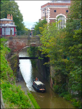
The
section
that
passes
under
the Phoenix
Tower and
the
old
sandstone
arch
outside
the Northgate is
quite
spectacular
and
well
worth deviating from your walk around the City Walls to investigate.
 Chester
is
a
popular
centre
for
canal
holidays
and
in
the
summer
months,
as
you
look
down
from
the
wall,
you
will
see
many
craft
passing
by,
on
their
way
into
rural
Cheshire, to Ellesmere Port or
via
the
spectacular Llangollen
Canal into
North
Wales. Chester
is
a
popular
centre
for
canal
holidays
and
in
the
summer
months,
as
you
look
down
from
the
wall,
you
will
see
many
craft
passing
by,
on
their
way
into
rural
Cheshire, to Ellesmere Port or
via
the
spectacular Llangollen
Canal into
North
Wales.
Once,
however,
these
canals
were
the
motorways
of
their
day
and
Chester
was
an
important
junction
and
distribution
centre
in
the
system.
From
the
last
quarter
of
the
Eighteenth
Century
to
the
end
of
the
Second
World
War,
generations
of
horse-drawn
working
craft
would
have
passed
this
way,
which
not
only
carried
all
manner
of
heavy
goods,
but
were
also
homes
to
the
bargees
and
their
often-large
families.
Where
the
canal
turns
the
corner
under
the
Phoenix
Tower,
you
can
still
clearly
see
where
their
tow ropes
have
worn
deep
grooves
into
the
sandstone (illustrated left). Nearby canal bridges exhibit the same phenomena, only on these, the grooves have been worn into solid cast iron!
We
will
learn
more
of
the Chester Canal
when
we
visit Tower
Wharf,
later
in
our
stroll and also on these pages, especially devoted to the subject.
As
we
proceed
further
along
the
North Wall,
on
the
right
and
behind
Rufus
Court,
we
see
the
pleasant
garden
area
known
as Abbey
Green,
behind
which
are
some
handsome
18th
century
houses,
and
in
the
background
rises
the
tower
of
our fine Gothic Town
Hall.
 The
bases
of
two
vanished
Roman
interval
towers
lie
under
the
grass
at
our
feet.
The
bricked-up
doorway
on
the
wall
to
our
right
was
built
in
1768
by
one Thomas
Boswell
as
an
entrance
to
Abbey
Green
and
a
long-vanished bowling
green
built
on
the
Abbey
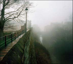
orchard. You can see it just to the left of the lamp post in this misty winter's day view. The
bases
of
two
vanished
Roman
interval
towers
lie
under
the
grass
at
our
feet.
The
bricked-up
doorway
on
the
wall
to
our
right
was
built
in
1768
by
one Thomas
Boswell
as
an
entrance
to
Abbey
Green
and
a
long-vanished bowling
green
built
on
the
Abbey
orchard. You can see it just to the left of the lamp post in this misty winter's day view.
(These attractive, crown-topped former gaslamps that light this stretch of the North Wall are of an unusual design, in that they incorporate a hinged mechanism, enabling their upper sections to be swung down to walkway level, thus avoiding the danger of anyone changing the bulbs slipping from their ladder and plummeting into the chasm below).
A contributor to the sadly-defunct Cheshire Sheaf (of which more below) in February 1913 wrote the following, "people familiar with the walls of Chester between King Charles' Tower and the Northgate will, no doubt, have noticed a door, set in a frame of brickwork, and opening upon steps leading to the quiet cul-de-sac known as Abbey Green. The little group of houses bearing this adress, with their cobbled approaches, their frontages of mellowed brick and regular rows of windows, although possessing no great individuality, are of a certain interest by reason of their air of solid comfort and respectability, and on account of the rapid rate at which dwelling houses of this period are being deserted for those of a more recent type, which, if they offer a greater variety to the eye, cannot, in many instances, compare with the former as regards material and workmanship. The doorway was apparently made as a result of a petition to the Mayor and Corporation enrolled in the Assembly Book under the date 30 September 1768. In it Thomas Boswell stated that he had lately erected several houses on a piece of land between the Abbey Court and the Walls of the City, and was desirous of having a footway off the Walls to the said houses, but was prevented from having such way by a rail lately fixed to the Walls. He therefore prayed leave to cut off about a yard of the said rail so as to open a way as desired. An inspection was ordered and evidently the petitioner eventually received a favourable answer".
 The local press of July 1817 informed its readers that, "Miss Marianne Briscoe, reflecting with gratitude upon the kind interest, favour and partronage which she has already experience in her Ladies' Boarding School in Abbey Green, Chester, hopes that her assiduous care to promote those mental, personal and religious acquirements which are of such infinite importance in the formation of the female character, will ensure for her establishment the encouragement and approbation of the public". The local press of July 1817 informed its readers that, "Miss Marianne Briscoe, reflecting with gratitude upon the kind interest, favour and partronage which she has already experience in her Ladies' Boarding School in Abbey Green, Chester, hopes that her assiduous care to promote those mental, personal and religious acquirements which are of such infinite importance in the formation of the female character, will ensure for her establishment the encouragement and approbation of the public".
The Cheshire Sheaf, incidentally, was a “notes and queries” column, in which contributors asked and answered questions about all aspects of local history, culture and folklore. It was published in the pages of the local press between the years 1878 and 1990. In 2006, the entire vast archive was lovingly collected together and published as a searchable 2-CD set by Cheshire and Chester Archives and Local Studies. A fabulous research tool- and a lively read for anyone interested in the history of our city and county- it may be purchased here. Much of it may also be read online for free here.
Immediately
after passing by Abbey Green,
visible
across
the
larger Deanery
Field rises the venerable Chester
Cathedral,
which
we
will
shortly
be
visiting. Excavations
on
this
field
have
shown
that
this
section
of
the
Roman
fortress
was
largely
occupied
by
barrack
blocks-
over
sixty
of
which,
each
housing
a
'century'- eighty
men
and
a
centurion,
were
packed
within
the
walls. For
centuries
after
this
whole
area
was
occupied
by
gardens
and
cultivated
land,
remarkably
remaining
unbuilt-upon
to
this
day.
As late as 1855, as is shown in this detail from John McGahey's remarkable aerial view of Chester, cattle grazed on the field. These
agricultural
areas
within
the
walls
were
a
common
feature
of
medieval
Chester,
doubtlessly proving to be valuable assets during times of siege, places of safety for domestic animals brought in from surrounding farms. Today
the
verdant Deanery
Field
is
the last survivor and to our visitors is perhaps
a
surprising
sight
in
such
a
small,
closely-packed
city
centre.
And long
may
it
remain
so! We will learn more of it soon, when we reach The Kaleyard Gate.
Modern Times
 The modern age is very much in evidence as we look across the canal from the North Wall. A
Primitive
Methodist
Chapel, shops and pub
formerly
stood
where
the Delamere
Street
Bus
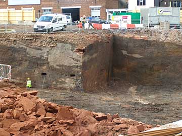
Station until recently was located. (Some pictures of the area as it once was are here.) Its demolition commenced during the late summer of 2005 and the site will be partially utilised as an underground car park as part of the massive- and controversial- Northgate Redevelopment scheme and also for the erection of shops and apartments. By April 2008, work on excavating the ground was well advanced. Our photograph shows the fascinating sight of an ancient quarry, exposed to view for the first time in centuries. The modern age is very much in evidence as we look across the canal from the North Wall. A
Primitive
Methodist
Chapel, shops and pub
formerly
stood
where
the Delamere
Street
Bus
Station until recently was located. (Some pictures of the area as it once was are here.) Its demolition commenced during the late summer of 2005 and the site will be partially utilised as an underground car park as part of the massive- and controversial- Northgate Redevelopment scheme and also for the erection of shops and apartments. By April 2008, work on excavating the ground was well advanced. Our photograph shows the fascinating sight of an ancient quarry, exposed to view for the first time in centuries.
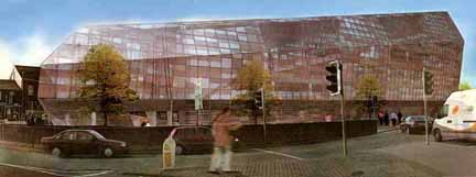
Work proceeded as far as the erection of the car park's steelwork in the bed of the old quarry and then ground to a halt, a situation that remains at this most recent updating in September 2011. However, around this time, developers Watkin Jones announced a new proposal for the site, a £20 million vast and charmless utilitarian building housing a combination of council offices, 149 student apartments and a National Health Service 'super centre'.
Soon after the first 'artist's impressions' (below) hit the local press, the Chester Civic Trust expressed their criticism of the proposed structure, saying they were "disappointed" with the design and dubbing it "obtrusive and out of scale with the immediate surroundings, particularly Northgate Street and the City Walls". They added, "the sheer height of the proposed buildings.. will produce a gloomy canyon of an inner courtyard. The north-facing rooms in the student block will be dark and have a cramped, unpleasant outlook".
The Civic Trust observed that these proposals would be an immediate test of a 'manifesto for contemporary design' demanded by Chester's people under the new One City Plan. This states that "a number of recent developments [the vile new Travelodge and its neighbouring apartment block being just two examples], by general consent, have fallen short of the level of excellence of design to which the city aspires and deserves". In order to be considered a 'must-see' city, the One City Plan says that developments must be designed and implemented "to the highest possible contemporary standard". Hear hear to that we say.
 However, in late December 2011, we learned that councillors had overwhelmingly voted in favour of the massive new development, which the Civic Trust described as "mediocre" and "monstrous in scale". Their spokesman, John Henson said "the firm [Watkin Jones] that brought you the Travelodge and the social housing block on the Ring Road is now about to bring you an even bigger development looming over the whole of Northgate Street and the City Walls". He queried the council's competence to consider the application in an unbiased way, given that it would be one of the occupiers. However, in late December 2011, we learned that councillors had overwhelmingly voted in favour of the massive new development, which the Civic Trust described as "mediocre" and "monstrous in scale". Their spokesman, John Henson said "the firm [Watkin Jones] that brought you the Travelodge and the social housing block on the Ring Road is now about to bring you an even bigger development looming over the whole of Northgate Street and the City Walls". He queried the council's competence to consider the application in an unbiased way, given that it would be one of the occupiers.
A test of a 'manifesto for contemporary design'? Failed.
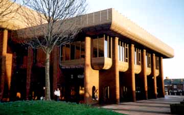
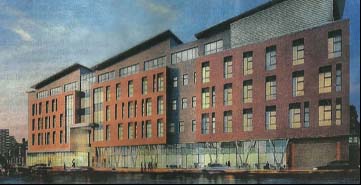
Beyond
the building work,
on
the
site
now
occupied
by
Chester's
main
swimming
baths
and
indoor
sports
venue,
the Northgate
Arena (illustrated above),
from 1875 to 1969 formerly
stood
the
old Northgate
Railway Station. (for those wishing to learn more, an excellent website about it is here- part of Disused Stations).
Chester is not renowned for the quality of its 1960s / 70s architecture but to many, this writer included, the Arena is an exception. Its interior may possibly be in need of some sprucing up and the building would benefit from an extension to provide extra sports and leisure facilities, but there is, in theory, ample room to allow for that. Encased in parts in maturing greenery and surrounded by trees, the Northgate Arena is a handsome building that does much to relieve the somewhat grim environment of the Inner Ring Road and its pools and other facilities are extremely popular with local people. In January 2008, it beat over 450 other entrants to be named the best leisure centre in the UK by the Association for Public Service Excellence (APSE).
The
large
open
space
outside
the
wall
at
this
point
was
for
centuries
common land and
known
by
the
curious
name
of the Gorse
Stacks,
owing
to
part
of
it
at
one
time
being utilised
for
the
safe
storage
outside
the
walls
of
brushwood
and
suchlike
fuel
for
baker's
ovens.
Formerly, firewood had been merely stacked up anywhere that was convenient, often in close proximity to the wooden houses and shops. Consequently, when fire broke out, the results were extensive and disastrous and records show that great areas of the town were destroyed by fire on numerous occasions over the centuries. After the Great Fire of London in 1666, new laws were introduced which forbade the storing of fuel within occupied areas and open land such as Gorse Stacks were instead utilised.
In early Anglo-Saxon times, the area had been called 'Henwald's Lowe', a combination of an Old English personal name and the Old English hlaw, meaning 'mound' or 'hill'. We have no idea who Henwald was, but must presume that he was a personage of importance whose burial followed the tradition of taking place on an area of elevated ground overlooking his former domains. Today, no trace remains of old Henwald's hill and the area
has become a fairly unattractive
place
used
for
car
parking and
its future
has
for
long
been
the
subject
of
much
local
debate.
Once
the
centre
of
a
thriving
commercial
district
centred
upon
the Cattle
Market,
which
was
demolished
in
the
1960s
to
make
way
for
a
traffic
island
on
the Inner
Ring
Road,
it
is
generally
accepted
to
be
in
urgent
need
of
improvement.
 Major
reports
in
1964
and
1968
recommended
the
area
be
redeveloped
and the
building
of
a
hotel
here
was
proposed,
but
not
acted
upon,
at
the
end
of
the
1980s.
Then,
in
1995,
it
was
proposed
to
enclose
the
entire
area
within
a
new Millennium
Wall,
within
which
would
be
created
a
landscaped
'cultural
quarter'
containing
galleries,
shops,
restaurants
and
the
like-
plus
a
new
public
square
and
open
air
market. I t
was
estimated
that
the
project
would
cost
an
astonishing £118 million, much
of
which
was
expected
to
come
from
the
private
sector
and
local
authority,
but
over £60
million
was
applied
for
from
the
Millennium
Commission-
unsuccessfully, to nobody's great surprise. Without
this
crucial
funding,
the
entire
project
foundered
and
no
mention
of
it
has
since
been
heard-
although,
independently
of
this,
many of us in Chester have expressed a strong desire
that
a
much-needed, purpose-built
concert
hall,
cinema, exhibition
and
arts
complex be built somewhere in our city centre. Major
reports
in
1964
and
1968
recommended
the
area
be
redeveloped
and the
building
of
a
hotel
here
was
proposed,
but
not
acted
upon,
at
the
end
of
the
1980s.
Then,
in
1995,
it
was
proposed
to
enclose
the
entire
area
within
a
new Millennium
Wall,
within
which
would
be
created
a
landscaped
'cultural
quarter'
containing
galleries,
shops,
restaurants
and
the
like-
plus
a
new
public
square
and
open
air
market. I t
was
estimated
that
the
project
would
cost
an
astonishing £118 million, much
of
which
was
expected
to
come
from
the
private
sector
and
local
authority,
but
over £60
million
was
applied
for
from
the
Millennium
Commission-
unsuccessfully, to nobody's great surprise. Without
this
crucial
funding,
the
entire
project
foundered
and
no
mention
of
it
has
since
been
heard-
although,
independently
of
this,
many of us in Chester have expressed a strong desire
that
a
much-needed, purpose-built
concert
hall,
cinema, exhibition
and
arts
complex be built somewhere in our city centre.
We may have entertained views for or against the ill-fated Millennium Wall, but in the Spring of 2004 we first heard news of a truly dotty plan hatched up by Chester City Council and Dutch insurers/property developers ING- who were also supposed to be undertaking the controversial Northgate Redevelopment- for the erection of a massive new glass and steel council headquarters building on Gorse Stacks. The proposed design, however, was, to say the least, unpopular, attracting a great deal of ridicule and has ever since been referred to- most appropriately, as our illustration shows- as "The Glass Slug".
 Prince Charles, the Earl of Chester, to the annoyance of those local politicians who thought erecting such as this in a historic city centre was a bright idea, made it known that he thought the design was horrible too. Prince Charles, the Earl of Chester, to the annoyance of those local politicians who thought erecting such as this in a historic city centre was a bright idea, made it known that he thought the design was horrible too.
Soon afterwards, local elections were held. The Conservatives had pledged that, should they be elected, they would cancel the building. They did take control of the formerly Lib Dem / Labour-dominated council, for the first time in many years- and they did cancel the Slug. Ironically, in the Summer of 2009, another row broke out regarding the Conservative's plan to move into a 'glass palace' of their own- the details of which may be found here...
There remains no trace of the Northgate Development plans seven years after they were proposed, and what the future holds for the sorely-neglected Gorse Stacks area of Chester we can only wait and see.
But
now,
reaching
the
northeast
corner
of
the
City
Walls,
we
see
rising
before
us
the
venerable Phoenix
Tower...
Curiosities from Chester's History no. 3
 1069 Chester was the last remaining great town in England
to fall to the Conqueror's sword during the final stages of the Harrying
of the North in 1069-70, fully three years after the Battle of Hastings.
Numerous rumours had long been circulating about the difficult roads, the
position of the city (surrounded as it was by marshes and great forests),
of its numerous inhabitants- and of their obstinate courage: "Locorum asperitatum
et hostium terribilem ferocitatem". Many of William's nobles, worn out by
the struggles in the North and alarmed at these rumours, demanded their discharge.
Some actually retired to Normandy, abandoning the lands with which they had
already been rewarded; but the persuasive powers of Duke William prevailed-
he promised them great rewards, and, as the conquest of Chester was the last
of his projects, they would find rest after their victory. As it turned out,
as the Norman army drew near, the city (whose citizens had doubtless heard
equally terrifying rumours regarding the approaching foe) surrendered without
opposition. William granted the Earldom of Chester first to Walter de Gherbaud-
who, however soon returned to Normandy- and then to his nephew, Hugh D'Avranches-
know as 'Lupus' (the wolf) and, in later life, 'Hugh the Fat'- "To hold to
him and his heirs as freely by the sword as the King holds the Crown of England".
The Earldom became very powerful and virtually independent of the Crown, the
Earl having his own Parliament consisting of eight of his chosen Barons and
their tenants, and they were in no way bound by any laws passed by the English
Parliament with the exception of treason. The Castle was rebuilt and greatly enlarged and strengthened (becoming the 'caput' of
the Earldom)- as were the City Walls. 1069 Chester was the last remaining great town in England
to fall to the Conqueror's sword during the final stages of the Harrying
of the North in 1069-70, fully three years after the Battle of Hastings.
Numerous rumours had long been circulating about the difficult roads, the
position of the city (surrounded as it was by marshes and great forests),
of its numerous inhabitants- and of their obstinate courage: "Locorum asperitatum
et hostium terribilem ferocitatem". Many of William's nobles, worn out by
the struggles in the North and alarmed at these rumours, demanded their discharge.
Some actually retired to Normandy, abandoning the lands with which they had
already been rewarded; but the persuasive powers of Duke William prevailed-
he promised them great rewards, and, as the conquest of Chester was the last
of his projects, they would find rest after their victory. As it turned out,
as the Norman army drew near, the city (whose citizens had doubtless heard
equally terrifying rumours regarding the approaching foe) surrendered without
opposition. William granted the Earldom of Chester first to Walter de Gherbaud-
who, however soon returned to Normandy- and then to his nephew, Hugh D'Avranches-
know as 'Lupus' (the wolf) and, in later life, 'Hugh the Fat'- "To hold to
him and his heirs as freely by the sword as the King holds the Crown of England".
The Earldom became very powerful and virtually independent of the Crown, the
Earl having his own Parliament consisting of eight of his chosen Barons and
their tenants, and they were in no way bound by any laws passed by the English
Parliament with the exception of treason. The Castle was rebuilt and greatly enlarged and strengthened (becoming the 'caput' of
the Earldom)- as were the City Walls.
- 1071 Hugh D'Avaranches (Lupus) becomes first Earl
of Chester (-1101) after the refusal of the position by Gherbod.
- 1075 St John's Church rebuilt as a cathedral by Bishop Peter; work stopped on his death in 1085.
- 1086 In the great Domesday survey made this year, it was recorded that there were 205 houses less in Chester than in King Edward's time, the
city having been much devastated and looted by William's army.
- 1087 William the Conqueror died and was succeeded by his
third son, William Rufus (William II: 1056-1100)
- 1093 The Benedictine Abbey of St. Werburgh (the present day Chester Cathedral) was founded by Hugh Lupus and his Countess Ermentruda,
with the assistance of Anselm, the Abbot of Bec in Normandy, who brought with
him some of the monks of that abbey. The secular Canons previously on residence
in the Saxon building were turned out and their church virtually destroyed
in order to make way for the great Norman abbey which replaced it. Many parts
of the Norman building survive in the fabric of today's Cathedral, but of
the Saxon Minster there remains no trace. Richard of Bec becomes first Abbot
(-1116).
- 1095 The See of Chester translated from St John's to Coventry.
- 1100 William Rufus accidentally killed in the New Forest;
Succeeded by Henry I (1068-1135)- the fourth, and youngest, son of William the Conqueror.
- 1101 Earl Hugh Lupus died and was succeeded by his only legitimate
son, Richard (-1120). He was buried in the churchyard of the Abbey, but was
later reburied in the Chapter House.
Top of Page | Site Front Door | Site Index | Chester Stroll Introduction | The Northgate III | The Phoenix
Tower | ChesterTourist.com's Rufus Court page
|