The Black and White Picture Place
Old Maps and Aerial Photographs of Chester
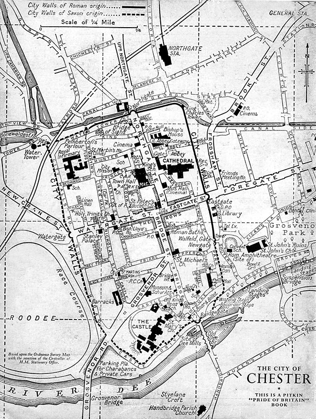
Before the Ring Road: 1950s Chester
Much remains familiar to the modern eye and, indeed, a gratifyingly large proportion of the ancient street pattern has survived intact to the present day. But, for those familiar with driving around modern Chester and visualising their routine journeys around the Ring Road, the map suddenly becomes bewildering, all such journeys then involving the use of the ancient and narrow streets within the walls. No wonder Chester by this time had a reputation as a terrible bottleneck for through-traffic and its streets were constantly choked by traffic jams!
(Mr Greenwood also suggested, among much else, a doubling of the area of Grosvenor Park to include an outdoor swimming pool and restaurant and the construction of a dignified civic centre and concert hall behind the Town Hall. None of his excellent proposals came about and the arguments about the use of the currently-grotty area behind the Town Hall and the need for a decent concert hall continue to this day.) Further huge traffic islands were built north of the Northgate and at the point where Brook Street meets Frodsham Street on the old map (these followed the line of the ancient Roman road from Warrington)- the wide new road joining them, and continuing on to meet Foregate Street at the point where Seller Street is marked on the far right-hand side, being called St. Oswald's Way. As a result, the fortunes of Brook Street was transformed, turning from the prestigious main route into the city from the railway station into a somewhat depressed area, home to a wealth of second-hand shops.. Half a century has now gone by since the Inner Ring Road was built and it is indeed difficult to imagine trying to get around the city without it. In places, its concrete brutality still resembles somewhat of a raw scar on the ancient street pattern and buildings. With hindsight, many have felt that, on some levels, the siting of the road proved to be disastrous and that choosing a route set outside of the City Walls would have proved a far better way of preserving much more of that which makes Chester special. There are numerous other features of interest on the map, include the Northgate Railway Station at the top- long gone and now the site of Chester's fine swimming and fitness centre, the Northgate Arena- the mention of "Roman amphitheatre (site of)"- possibly the excavation had yet to get underway at this time?- the 'barracks' on Castle Esplanade; these were the Militia Buildings which were built just after the Crimea War in 1854-6 and used as married quarters for the families of troops serving at the Castle. The site was later occupied by the ugly Cheshire Police headquarters. This in turn was demolished in 2006 and 'HQ', a vast new development of council offices, apartments and hotel has now risen on the site. |
 Today, a large traffic island exists outside the
  From here, the new road followed the line of Union Street, Vicar's Lane, around the
 On to a Cold War Soviet map of Chester or to John McGahey's magnificent View of Chester From a Balloon 1855
Site Front Door | Chester Walls Stroll Introduction | Old Maps & Aerial Photographs | Site Index