The
Black & White
Picture
Place
Old Maps and Aerial Photographs of Chester
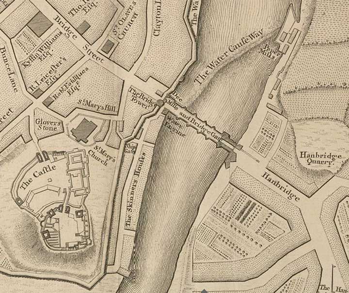
Lavaux's Map of Chester 1745: the Castle & Old Dee Bridge
In this, the first of a series of enlargements from Lavaux's map of Chester, we see an interesting plan of the medieval castle, isolated on its high motte. Thirty five years after this plan was published, virtually every stone of this great building would be swept away to be replaced by Thomas Harrison's Greek Revival 'castle'. 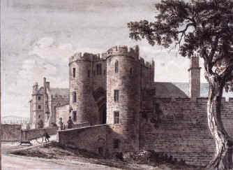 Just above it, adjoining St. Mary's Church, we see Gloverstone, a sort of no-man's land between the administrations of the castle and the town. It was here that criminals tried and condemned in the castle courts would be handed over to the town authorities to be executed at Boughton. Just above it, adjoining St. Mary's Church, we see Gloverstone, a sort of no-man's land between the administrations of the castle and the town. It was here that criminals tried and condemned in the castle courts would be handed over to the town authorities to be executed at Boughton. Over the City Wall and next to the River Dee once ran Skinner's Lane, shown here as The Skinner's Houses, where all manner of unpleasant industrial processes that required plentiful water and relative isolation from the rest of the town were carried out- tanning, the rendering of animal by-products, and chemical production, to mame a few. The pollution of the river resulting from these processes must have been considerable, especially at a time when the Dee supported a thriving fishery and most people's domestic water supplies came straight from the same source. Nearly a century later, in the early 1830s, the city authorities, anxious to improve the situation, eventually acquired this area, extended the city wall to enclose it and removed all trace of the offending premises. Castle Drive was created at this time. Notice the presence of the Ship Gate, a small entrace throught the City Walls that, long before this map was made, was a busy entrance to Chester from the River Dee and, before the silting of the river destroyed the port, was the main place were ships would discharge their cargo and send it into the city via packhorses up steep St. Mary's Hill. The old gateway was removed in 1828 and the place where it had stood for centuries was sealed up. After spending some years as a folly in a private garden in Abbey Square, the stones of the old gateway were re-erected in 1897 in Grosvenor Park where they remain today, as shown in this photograph. Crossing the River Dee, exactly as it does today- we see the Old Dee Bridge, a venerable sandstone structure that was built in the year 1387, replacing a series of earlier wooden bridges and standing on, or close to, the site of a pre-Roman fording place. 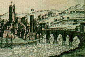 At the end of the bridge, the strongly fortified Bridgegate allowed access to the city. On top of this gate was a tall tower which was constructed in 1600 to supply water pumped up from the river and distributed through lead pipes to wooden troughs located throughout the city. The old gate's narrow entrances had long proved an obstacle to traffic and it was demolished in 1782 and replaced by an elegant archway, designed by Joseph Turner, which remains with us today. The map shows extensive fortifications existing at the Handbridge (at that time spelled 'Hanbridge') end of the bridge. These too have now entirely vanished. At the end of the bridge, the strongly fortified Bridgegate allowed access to the city. On top of this gate was a tall tower which was constructed in 1600 to supply water pumped up from the river and distributed through lead pipes to wooden troughs located throughout the city. The old gate's narrow entrances had long proved an obstacle to traffic and it was demolished in 1782 and replaced by an elegant archway, designed by Joseph Turner, which remains with us today. The map shows extensive fortifications existing at the Handbridge (at that time spelled 'Hanbridge') end of the bridge. These too have now entirely vanished.This suburb across the river appears at this time to almost entirely given over to farms, gardens and quarries. The Handbridge maypole can just be seen in the bottom right-hand corner. Before it was removed, in 1850, it was seen and written of by the American author, Washington Irving (best remembered today for his stories 'The Legend of Sleepy Hollow' and 'Rip Van Winkle')- who recalled seeing it on a visit to Chester around 1825, "I shall never forget the delight I felt on first seeing a May-pole. It was on the banks of the Dee, close by the picturesque old bridge that stretches across the river from the quaint little city of Chester. I had already been carried back into former days by the antiquities of that venerable place... the May-pole on the margin of that poetic stream completed the illusion. My fancy adorned it with wreaths of flowers and peopled the green bank with all the dancing revelry of May-day. The mere sight of this May-pole gave a glow to my feelings and spread a charm over the country for the rest of the day". |
Here are some more details from Lavaux's map of Chester:
|
|
|
|
|
|
|
|
Back to Lavaux's map of Chester
Site
Front
Door
|
Chester
Walls
Stroll
Introduction
|
Old
Maps
&
Aerial
Photographs
|
Site
Index